
East Liverpool is a city in southeastern Columbiana County, Ohio, United States. The population was 9,958 at the 2020 census. It lies along the Ohio River within the Upper Ohio Valley and borders Pennsylvania to the east and West Virginia to the south. East Liverpool is included in the Salem, Ohio micropolitan area, about 34 miles (55 km) from both Youngstown and downtown Pittsburgh.

Ohio Drive is a street in Southwest Washington, D.C., located in East and West Potomac Parks and bordering the Tidal Basin, Washington Channel, and the Potomac River. It is a central organizing feature of East Potomac Park, providing the only major vehicular route to and through the area. Unlike most roadways named after states in the District of Columbia, Ohio Drive is not an avenue, nor it is heavily used like Wisconsin or Rhode Island Avenues. However, the segment from Independence Avenue to the Rock Creek and Potomac Parkway is an important commuter route.
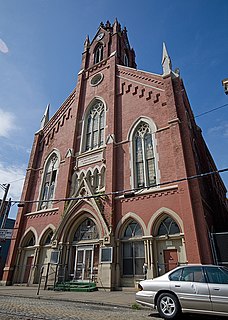
The Apostolic Bethlehem Temple Church is a historic church building in the Over-the-Rhine neighborhood of Cincinnati, Ohio, United States. A German Gothic Revival structure built in 1868, it was constructed as the home of the German Evangelical and Reformed Church, Cincinnati's oldest German Reformed Church. Founded in 1814, the church changed its name to "St. John's German Protestant Church" in 1874, although it remained in the German Reformed Church. This situation continued until 1924, when it departed for the American Unitarian Association and changed its name to "St. John's Unitarian Church." Little more than twenty years later, the congregation abandoned its old building, leaving it vacant until it was purchased by the present owners, a Pentecostal church.

This is a list of the National Register of Historic Places listings in Columbiana County, Ohio.

This is a list of the National Register of Historic Places listings in Muskingum County, Ohio.
This is intended to be a complete list of the properties and districts on the National Register of Historic Places in downtown Cincinnati, Ohio, United States. Downtown Cincinnati is defined as being all of the city south of Central Parkway, west of Interstates 71 and 471, and east of Interstate 75. The locations of National Register properties and districts may be seen in an online map.
This is a list of the National Register of Historic Places listings in eastern Cincinnati, Ohio.

The Elks Club in East Liverpool, Ohio was built in 1916. It was listed on the National Register of Historic Places in 1985.

The Godwin–Knowles House is a historic former house in downtown East Liverpool, Ohio, United States. A Colonial Revival structure built in 1890, it has played important parts both in the city's industry and in its society.

The YMCA in East Liverpool, Ohio was built in 1913 in Classical Revival style. It was listed on the National Register of Historic Places in 1985.

The Cassius Clark Thompson House is a historic residence on the edge of downtown East Liverpool, Ohio, United States. Built in 1876 in a Late Victorian form of the Italianate style of architecture, it was built as the home of one of East Liverpool's leading businessmen.
The East Liverpool Downtown Historic District is located in East Liverpool, Ohio. The district, which covers approximately 22 acres (8.9 ha), was added to the National Register of Historic Places in May 2001.The district is bordered by West Sixth Street, Dresden Avenue, Welch Avenue, Broadway, Walnut and East Fourth Streets, and East Alley.
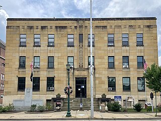
The City Hall in East Liverpool, Ohio is part of the East Liverpool Central Business District multiple resource area (MRA). It was added to the National Register of Historic Places on November 14, 1985.
The East Fifth Street Historic District, located in East Liverpool, Ohio, was added to the National Register of Historic Places in November 1985. The district encompasses three blocks of downtown East Liverpool along East Fifth street between Market Street and Broadway.

The Downtown Commercial Historic District encompasses most of the central business district of Burlington, Iowa, United States. It was listed on the National Register of Historic Places in 2015. The historic district includes 65 properties that were part of a 2012 to 2013 survey of the area. It also includes as contributing properties the buildings in the West Jefferson Street Historic District and three buildings in the Manufacturing and Wholesale Historic District that were previously listed on the National Register. All total there are 122 resources within the district, which includes 108 contributing and 14 non-contributing properties.

The Columbus Civic Center is a civic center, a collection of government buildings, museums, and open park space in Downtown Columbus, Ohio. The site is located along the Scioto Mile recreation area and historically was directly on the banks of the Scioto River.
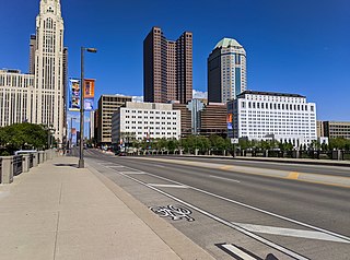
Broad Street is a major thoroughfare in Central Ohio, predominantly in Franklin County and Columbus. It stretches east from West Jefferson at Little Darby Creek to Pataskala. The street is considered one of Columbus's two main roads, along with High Street.

High Street is a major thoroughfare in Central Ohio, predominantly in Franklin County and Columbus. It stretches from the northern border of Columbus in Delaware County south to the southern boundary of Franklin County just past Columbus's municipal boundaries. The street is considered one of Columbus's two main roads, along with Broad Street.


