
Hunter is a town located in Greene County, New York, United States. The population was 2,732 at the time of the 2010 census. The town contains two villages, one named Hunter on the west, and the second called Tannersville, as well as a number of hamlets such as Haines Falls, Platte Clove, Lanesville and Edgewood. Additionally, there are three residential parks location within town limits: Onteora Park, Twilight Park and Elka Park. The town is on the southern border of Greene County and abuts the towns of Woodstock and Saugerties, located in Ulster County.

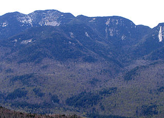
The Catskill Mountains, also known as the Catskills, are a physiographic province of the larger Appalachian Mountains, located in southeastern New York. As a cultural and geographic region, the Catskills are generally defined as those areas close to or within the borders of the Catskill Park, a 700,000-acre (2,800 km2) forest preserve protected from many forms of development under New York state law.

The Sangre de Cristo Mountains are the southernmost subrange of the Rocky Mountains. They are located in southern Colorado and northern New Mexico in the United States. The mountains run from Poncha Pass in South-Central Colorado, trending southeast and south, ending at Glorieta Pass, southeast of Santa Fe, New Mexico. The mountains contain a number of fourteen thousand foot peaks in the Colorado portion, as well as several peaks in New Mexico which are over thirteen thousand feet.
Armstrong Mountain is a mountain located in Essex County, New York, named after Thomas Armstrong, a local pioneer. The mountain is part of the Great Range of the Adirondack Mountains. Armstrong Mtn. is flanked to the southwest by Gothics, and to the northeast by Upper Wolfjaw Mountain.
Lone Mountain is a mountain located in Ulster County, New York. The mountain is part of the Catskill Mountains. Lone Mountain is flanked to the southwest by Table Mountain, and to the east by Rocky Mountain.

Berlin Mountain is a 2,818-foot-tall (859 m) prominent peak in the Taconic Mountains of western New England and is located adjacent to Massachusetts's border with New York State. It is the highest point in Rensselaer County. The summit and west side of the mountain are located in New York; the east side lies within Williamstown, Massachusetts. The mountain is a bald, notable for its grassy summit and expansive views of the Hudson River Valley to the west. The 37-mile (60 km) Taconic Crest Trail traverses the mountain. Several other hiking trails approach the summit from the east. Much of the upper slopes and summit are within protected conservation land. Historically the lower slopes of the mountain were farmed heavily throughout the 19th Century. In addition to agriculture, there are several remnants of charcoal kilns located on the mountain that produced fuel for iron smelting.
Boiceville is a hamlet in the town of Olive, Ulster County, New York, United States. Located at the intersection of New York State Route 28 and New York State Route 28A, Boiceville is within Catskill State Park.

The Theodore Roosevelt Council, 386 is a local council of the Boy Scouts of America. It is one of the nation's oldest, having been home to its namesake, the former US president, who was a founding member of BSA.
Onteora Central School District is a school district in Boiceville, New York, United States.

Dun Brook Mountain is a mountain located in Adirondack Mountains of New York located in the town of Indian Lake east-northeast of Blue Mountain Lake. Tirrell Mountain is located west and Tirrel Pond is located west-southwest of Dun Brook Mountain.
Bell Mountain is a mountain located in Adirondack Mountains of New York located in the Town of Indian Lake east of Indian Lake.
Red Hill is a mountain located in the Catskill Mountains of New York east-south of Frost Valley. Woodhull Mountain is located northeast of Red Hill.

Huntersfield Mountain is a mountain located in the Catskill Mountains of New York north-northwest of Ashland. Ashland Pinnacle is located east, and Tower Mountain is located south-southeast of Huntersfield Mountain. It is the highest point in Schoharie County and it is ranked 9 of 62 on the list of New York County High Points.
Parker Mountain is a mountain located in the Catskill Mountains of New York east-northeast of Hunter. Onteora Mountain is located west, Stoppel Point is located east, Black Dome is located north-northeast, Star Rock is located east-northeast, and Thomas Cole Mountain is located north of Parker Mountain.
Richmond Mountain is a mountain located in the Catskill Mountains of New York east-northeast of Hunter. Richtmyer Peak is located northeast, Bump Mountain is located south, Steenburg Mountain is located north, and Ashland Pinnacle is located west-southwest of Richmond Mountain.
Richtmyer Peak is a mountain in Greene County, New York and partly in Schoharie County, New York. It is located in the Catskill Mountains southwest of West Durham. Mount Pisgah is located east, and Richmond Mountain is located southwest of Richtmyer Peak.
East Jewett Range is a mountain in Greene County, New York. It is located in the Catskill Mountains west-southwest of Maplecrest. Van Loan Hill is located north, and Onteora Mountain is located east-southeast of East Jewett Range.

