Jakarta, officially the Special Capital Region of Jakarta and formerly known as Batavia until 1949, is the capital city of Indonesia and an autonomous region at the provincial level. Lying on the northwest coast of Java, the world's most populous island, Jakarta is the largest metropole in Southeast Asia and serves as the diplomatic capital of ASEAN. The Special Region has a status equivalent to that of a province and is bordered by two other provinces: West Java to the south and east; and Banten to the west. Its coastline faces the Java Sea to the north, and it shares a maritime border with Lampung to the west. Jakarta's metropolitan area is ASEAN's second largest economy after Singapore. In 2023, the city's GDP PPP was estimated at US$724.010 billion.

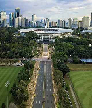
Gelora Bung Karno Main Stadium, formerly Senayan Main Stadium and Gelora Senayan Main Stadium, is a multi-purpose stadium located at the center of the Gelora Bung Karno Sports Complex in Central Jakarta, Indonesia. It is mostly used for football matches, and usually used by the Indonesia national football team and Liga 1 club Persija Jakarta. The stadium is named after Sukarno, the then-president of Indonesia, who sparked the idea of building the sports complex.
Gelora Bung Karno Sports Palace, is an indoor arena located in Gelora Bung Karno Sports Complex, Jakarta, Indonesia. The capacity of the arena after 2018 reopening is 7,166. This arena is usually used for badminton tournaments, especially the BWF tournaments Indonesia Open and Indonesia Masters, as well as the Indonesia men's national basketball team. The first event that held in this arena was the 1961 Thomas Cup.

North Jakarta, abbreviated as Jakut, is one of the five administrative cities which form Special Capital Region of Jakarta, Indonesia. North Jakarta is not self-governed and does not have a city council, hence it is not classified as a proper municipality. It contains the entire coastal area within the Jakarta Special Capital Region. North Jakarta, along with South Jakarta is the only two cities in Jakarta to border Banten and West Java. It is also the only city of Jakarta with a coastline and thus not landlocked. North Jakarta, an area at the estuary of Ciliwung river was the main port for the kingdom of Tarumanegara, which later grew to become Jakarta. Many historic sites and artefacts of Jakarta can be found in North Jakarta. Both ports of Tanjung Priok and historic Sunda Kelapa are located in the city. The city, which covers an area of 139.99 km2, had 1,645,659 inhabitants at the 2010 census and 1,778,981 at the 2020 census; the official estimate as at mid 2023 was 1,801,963. It has its administrative centre in Tanjung Priok.

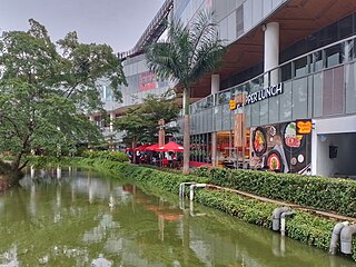
Senayan City is a mixed-use development located in Senayan area, Central Jakarta, Indonesia. The complex comprises a seven-floor high end shopping mall, two boutique office towers and an apartment tower. During construction, premium hotel chain Sofitel had planned to open in Senayan City with an estimated opening for 2007, which was ultimately scrapped. Senayan City is built on a land area of 48,000 m2 (520,000 sq ft) owned by the Bung Karno Stadium Authority. It is built and managed by Manggala Gelora Perkasa, a subsidiary of Agung Podomoro Group, under the BOT contract for 50 years which starts in 2005. They used Pulau Intan as their main contractor, Structure and mechanical engineering contractor. The development was designed by DP Architects.

Pademangan is a port-associated district (kecamatan) of North Jakarta Administrative City, Indonesia. It stretches from the Sunda Kelapa Harbour in the west to the western area of Tanjung Priok Harbor in the east. Geographically, it is a plain with an average height of 75 centimeters above the high tide sea level.

Penjaringan is a district of North Jakarta Administrative City, Indonesia. It is the westernmost district of North Jakarta. Muara Angke Port and the mouth of Sunda Kelapa Port are located within Penjaringan. Penjaringan contains the remnants of the original mangrove forest of Jakarta, some of which are protected by the Muara Angke Wildlife Sanctuary.

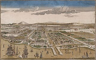
Jakarta is Indonesia's capital and largest city. Located on an estuary of the Ciliwung River, on the northwestern part of Java, the area has long sustained human settlement. Historical evidence from Jakarta dates back to the 4th century CE, when it was a Hindu settlement and port. The city has been sequentially claimed by the Indianized kingdom of Tarumanegara, the Hindu Kingdom of Sunda, the Muslim Sultanate of Banten, and by Dutch, Japanese and Indonesian administrations. The Dutch East Indies built up the area before it was taken during World War II by the Empire of Japan and finally became independent as part of Indonesia.

Ancol is a coastal lowland area located to the east of Kota Tua Jakarta in northern Jakarta, in Indonesia. The coastal lowland stretched from Kota Tua Jakarta to the west and Tanjung Priok to the east. Today, Ancol contains the main beach resort of Jakarta. Taman Impian Jaya Ancol, the largest integrated tourism area in Southeast Asia, is located in Ancol.

The following is an alphabetical list of topics related to the Republic of Indonesia.

The Bung Karno Sports Complex, better known as Gelora Bung Karno and formerly named the Asian Games Complex (Indonesian: Kompleks Asian Games and the Senayan Sports Complex from 1969 to 2001, is a sports complex located in Gelora, Central Jakarta, bordering the Senayan, South Jakarta because of its large location. Originally built with substantial Soviet assistance, this sports complex was a brain child of Sukarno, the first President of Indonesia, in order to host the 1962 Asian Games. This sports complex consists of a main stadium, secondary stadium, the Sports Palace, football fields, aquatic stadium, tennis stadiums, hockey, baseball and archery fields, and several indoor gymnasiums. This complex was built in 1960 and underwent major renovation for the 2018 Asian Games and Asian Para Games.
The following is a timeline of the history of the city of Jakarta, Indonesia.

Jalan Jenderal Sudirman or Jalan Sudirman is a major thoroughfare in Jakarta, Indonesia. Named after Indonesian national hero Sudirman, the road runs from Patung Pemuda Membangun at the south end to the bridge of the West Flood Canal to the north, where it meets Jalan M.H. Thamrin. The road had been built between 1949 and 1953 to connect Central Jakarta with Kebayoran Baru.

Jalan Daan Mogot is one of the main avenues in Jakarta, Indonesia. The road is named after a military officer involved in the struggle for Indonesian independence Daan Mogot. This road stretches along 27.5 KM from Grogol, West Jakarta to Sukarasa, Tangerang, Tangerang. After entering Tangerang, this road continues to Jalan Merdeka and Jalan Gatot Subroto .This road is part of Indonesian National Route 1. This road crosses 14 urban villages, namely

Istora MRT Station is a rapid transit station on the North-South Line of the Jakarta MRT in Jakarta, Indonesia. Located on Jl. Jendral Sudirman, it is located between the Bendungan Hilir and Senayan stations, and has the station code IST.

The Cililitan-Tanjung Priok Road, also known as the Jakarta Bypass or simply Bypass, is a 27 km long bypass road in Jakarta, Indonesia that connects the Dewi Sartika Road and the Bogor Main Road in Cililitan, East Jakarta to the Port of Tanjung Priok in North Jakarta. The road is divided into four parts: Jalan Mayjen Sutoyo Road, Jalan D.I. Panjaitan, Jalan Jend. Ahmad Yani Road, and Jalan Laksamana Yos Sudarso. The bypass was inaugurated by the first President of Indonesia, Sukarno on October 21, 1963. One of the Jakarta Inner Ring Road sections is built over the road.

Senayan is a Transjakarta bus rapid transit station located in Jalan Jenderal Sudirman, Jakarta, Indonesia. The station, which primarily serves in corridor 1, is located adjacent with the Gelora Bung Karno Sports Complex at north.

Senayan Park is a shopping mall with an outdoor public recreational space in Jakarta, Indonesia. It is located north of the Gelora Bung Karno Sports Complex in Central Jakarta. Senayan Park is built on the former site of Taman Ria Senayan, Jakarta’s first amusement park, which existed from the early 1970s until the late 2000s.


