Bingöl, known as Çapakçur before 1944, is a city in Turkey. It is the seat of Bingöl Province and Bingöl District, having a population of 133,423 (2022).

Silistra is a town in Northeastern Bulgaria. The town lies on the southern bank of the lower Danube river, and is also the part of the Romanian border where it stops following the Danube. Silistra is the administrative center of the Silistra Province and one of the important towns of the historical region of Dobruja.
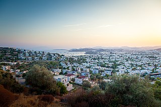
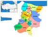
Bodrum is a municipality and district of Muğla Province, Turkey. Its area is 650 km2, and its population is 192,964 (2022). It is a port city at the entrance to the Gulf of Gökova. Known in ancient times as Halicarnassus, the city was once home to the Mausoleum at Halicarnassus, also known as the tomb of Mausolus, one of the Seven Wonders of the Ancient World.

Ankara Province is a province of Turkey with the capital city Ankara.
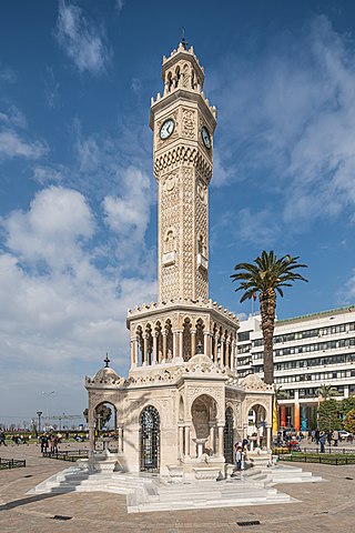
İzmir is a metropolitan city on the west coast of Anatolia, and capital of İzmir Province. It is the third most populous city in Turkey, after Istanbul and Ankara, and the largest urban agglomeration on the Aegean Sea.

Adıyaman Province is a province in the Southeastern Anatolia Region of Turkey. The capital is Adıyaman. The province is considered part of Turkish Kurdistan and has a Kurdish majority.

Denizli is an industrial city in the southwestern part of Turkey and the eastern end of the alluvial valley formed by the river Büyük Menderes, where the plain reaches an elevation of about three hundred and fifty metres (1,148 ft). Denizli is located in the country's Aegean Region.
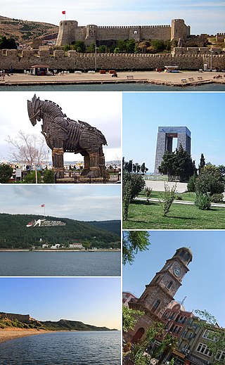
Çanakkale Province is a province of Turkey, located in the northwestern part of the country. It takes its name from the city of Çanakkale.

The Ağrı Province is a province in eastern Turkey, bordering Iran to the east, Kars to the north, Erzurum to the northwest, Muş and Bitlis to the southwest, Van to the south, and Iğdır to the northeast. It has an area of 11,376 km² and a population of 535,435 as of 2020. The provincial capital is Ağrı, situated on a 1,650 metres (5,410 ft) high plateau. Doğubayazıt was the capital of the province until 1946. The current governor is Süleyman Elban.

Ardahan Province is a province in the north-east of Turkey, bordering Georgia and Armenia. The provincial capital is the city of Ardahan. Ardahan borders the Turkish provinces of Erzurum, Artvin and Kars.
Balchik is a Black Sea coastal town and seaside resort in the Southern Dobruja area of northeastern Bulgaria. It is in Dobrich Province, 35 km southeast of Dobrich and 42 km northeast of Varna. It sprawls scenically along hilly terraces descending from the Dobruja plateau to the sea, and is often called "The White City" because of its white hills.

Fatih is a municipality and district of Istanbul Province, Turkey. Its area is 15 km2, and its population is 368,227 (2022). It is home to almost all of the provincial authorities but not the courthouse. It encompasses the peninsula coinciding with old Constantinople. In 2009, the district of Eminönü, which had been a separate municipality located at the tip of the peninsula, was once again remerged into Fatih because of its small population. Fatih is bordered by the Golden Horn to the north and the Sea of Marmara to the south, while the Western border is demarked by the Theodosian wall and the east by the Bosphorus Strait.

Kahramanmaraş, historically Marash and Germanicea, is a city in the Mediterranean region of Turkey and the administrative centre of Kahramanmaraş province. After 1973, Maraş was officially named Kahramanmaraş with the prefix kahraman to commemorate the Battle of Marash. The city lies on a plain at the foot of Mount Ahır.
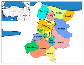
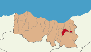
Geyve is a municipality and district of Sakarya Province, Turkey. Its area is 662 km2, and its population is 50,799 (2022). The closest international airport is Istanbul Sabiha Gökçen International Airport, 139 km (86 mi) from Geyve. It is the largest district of Sakarya Province in terms of area. Geyve is located at the foot of Geyve Gorge, which is set between two mountain ranges and lies along the Sakarya River. Geyve region has an impressive green landscape and productive nature. Geyve is relatively close to many important cities in Turkey; 179 km (111 mi) to Istanbul, 30 km to Adapazarı, 75 km (47 mi) to Izmit, 139 km to Bursa, 156 km (97 mi) to Eskişehir, 167 km (104 mi) to Bolu by road.

Akçaabat is a town and district of Trabzon Province in the Black Sea region of Turkey. It is located to the west of the city of Trabzon. It covers an area of 385 km2 (149 sq mi) and the elevation is ten metres (33 ft). The town has an estimated population of 48,315 (2007). Akçaabat is a coastal town known for its local soccer team Akçaabat Sebatspor, its kofta dish Akçaabat köfte and the Akçaabat Horonu dance. Akçaabat has hosted an international folklore festival since 1990, and it was a venue for Archery and Athletics competitions of the First Black Sea Games held in 2007.
Şalpazarı is a town and district of Trabzon Province in the Black Sea region of Turkey. The population is around 12,000 including the surrounding villages. The mayor is Refik Kurukız (MHP). Şalpazarı is a home to sizeable Chepni Turkmen population.
Dernekpazarı is a district of Trabzon Province in the Black Sea region of Turkey.The old name of the town was Kondu and the current mayor of the town is Mehmet Aşık (AKP). Dernekpazarı is part of the Of-valley system ; it lies between the coastal Of district and the alpine Çaykara district.

Of is a town and district of Trabzon Province in the Black Sea region of Turkey. It is located in the eastern part of Trabzon and is an important historical district of the province. The mayor is Salim Salih Sarıalioğlu (AKP).
Malagina, in later times Melangeia (Μελάγγεια), was a Byzantine district in the valley of the Sangarius river in northern Bithynia, at least overlapping the modern territory of Pamukova.
Arifiye is a district center of Sakarya Province, Turkey. It is also included in Greater Sakarya Proper.