The Anatolian side of Turkey is the largest portion in the country that bridges southeastern Europe and west Asia. East Thrace, the European portion of Turkey comprises 3% of the country and 10% of its population. East Thrace is separated from Asia Minor, the Asian portion of Turkey, by the Bosporus, the Sea of Marmara and the Dardanelles. İskilip, Çorum province, is considered to be the geographical center of Earth. Turkey has the 17th longest coastline in the world with 7,200 km.

Kastamonu Province is one of the provinces of Turkey, in the Black Sea region to the north of the country. It is surrounded by Sinop to the east, Bartın, Karabük to the west, Çankırı to the south, Çorum to the southeast and the Black Sea to the north.

Akçakoca is a town in Düzce Province, in the East Marmara region of Turkey, located about 200 km east of Istanbul. It is the seat of Akçakoca District. Its population is 27,878 (2022). The town was named after a Turkish chieftain of the 14th century CE who captured the area for the Ottoman Empire, and sports a statue in his honor. The town features a modern mosque of unusual design. Tourist attractions include beaches and a small ruined Genoese castle. It is the regional center of hazelnut cultivation.

Giresun Province is a province of Turkey on the Black Sea coast. Its adjacent provinces are Trabzon to the east, Gümüşhane to the southeast, Erzincan to the south, Sivas to the southwest, and Ordu to the west. Its license-plate code is 28.

Ordu Province is a province of Turkey, located on the Black Sea coast. Its adjacent provinces are Samsun to the northwest, Tokat to the southwest, Sivas to the south, and Giresun to the east. Its license-plate code is 52.

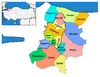
Sakarya is a province in Turkey, located on the coast of the Black Sea. The Sakarya River creates a webbing of estuaries in the province, which is in the Marmara Region. The adjacent provinces are Kocaeli to the west, Bilecik to the south, Bolu to the southeast and Düzce to the east. The capital of Sakarya is Adapazarı. Its climate is maritime in the north and humid subtropical in the south and changes by the distance to the Black Sea. Sakarya is on the Ankara-Istanbul highway and is also connected by rail. Sakarya is serviced by Istanbul's Sabiha Gökçen International Airport. The current mayor of Sakarya is Ekrem Yüce as of 2019. (AKP). The city of Sakarya, one of the most important cities in Turkey for its rapid growth and development, is also noteworthy for its natural beauties and its cultural richness. It is one of the paradise-like spots of the country with its sea, beaches, lakes, rivers, highlands, thermal springs, traditional Ottoman lifestyle districts such as Taraklı and Geyve and noteworthy historical relics that are inherited from the Byzantine and the Ottoman eras. The Turks conquered the city of Sakarya in the 13th century. There was intensive immigration from the Caucasus and the Balkans in the 18th and the 19th centuries. The last massive immigration was in 1989 from Bulgaria. The city has developed industry from being a transportation crossroads and still has inward domestic migration. Sakarya is notable in the Marmara Region. The city of Sakarya is surrounded with the city of Düzce in the east, Bolu in the south-east, Bilecik in the south, Kocaeli in the west and the Black Sea in the north. The city of Sakarya has 16 districts; Adapazarı, Akyazı, Arifiye, Erenler, Ferizli, Geyve, Hendek, Karapürçek, Karasu, Kaynarca, Kocaali, Pamukova, Sapanca, Serdivan, Söğütlü and Taraklı.

Ordu or Altınordu is a port city on the Black Sea coast of Turkey, historically also known as Cotyora or Kotyora, and the capital of Ordu Province with a population of 229,214 in the city center.
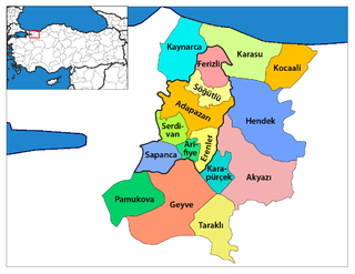
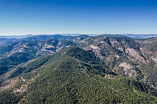
Geyve is a municipality and district of Sakarya Province, Turkey. Its area is 662 km2, and its population is 50,799 (2022). The closest international airport is Istanbul Sabiha Gökçen International Airport, 139 km (86 mi) from Geyve. It is the largest district of Sakarya Province in terms of area. Geyve is located at the foot of Geyve Gorge, which is set between two mountain ranges and lies along the Sakarya River. Geyve region has an impressive green landscape and productive nature. Geyve is relatively close to many important cities in Turkey; 179 km (111 mi) to Istanbul, 30 km to Adapazarı, 75 km (47 mi) to Izmit, 139 km to Bursa, 156 km (97 mi) to Eskişehir, 167 km (104 mi) to Bolu by road.

Düzce is a city in northwestern Turkey, the capital city of Düzce Province, the eighty-first Province in the country. It is the seat of Düzce District. Its population is 194,097 (2022).
Beşikdüzü is a town and district of Trabzon Province in the Black Sea region of Turkey. The mayor is Ramis Uzun (CHP).

Fındıklı is a town in Rize Province on the Black Sea coast of Turkey, east of the city of Rize. It is the seat of Fındıklı District. Its population is 10,886 (2021).

Kandıra is a municipality and district of Kocaeli Province, Turkey. Its area is 840 km2, and its population is 52,874 (2022). Its neighbours are Kaynarca to the east, Adapazarı to the southeast, İzmit to the south and Şile to the west.

Şarköy, formerly Peristasis, is a municipality and district of Tekirdağ Province, Turkey. Its area is 487 km2, and its population is 33,466 (2022). It is a seaside town on the north coast of the Marmara Sea in East Thrace. Şarköy is 86 km west of the town of Tekirdağ, and can be reached either by the inland road or by the winding coast road, which goes on to Gallipoli. The mayor is Alpay Var (CHP).
Yusufeli is a town and district of Artvin Province in the Black Sea region of Turkey. It is located on the bank of Çoruh River 104 km south-west of the city of Artvin, on the road to Erzurum. It is the seat of Yusufeli District. Its population is 7,306 (2021).
Karasu is a town in Sakarya Province, northwestern Turkey, on the Black Sea coast. It has an overwinter population of around 30,746, which increases in the summer due to tourism. Much of its commerce centers on hazelnut farming and tourism.

İnebolu is a town and district of the Kastamonu Province in the Black Sea region of Turkey. It is 590 km (367 mi) from Istanbul by road and 89 km (55 mi) north of Kastamonu. It is a typical Black Sea port town with many fine examples of traditional domestic architecture. It is the seat of İnebolu District. Its population is 10,594 (2021).

Sarıyar Dam is a dam 23 kilometres (14 mi) north of the town of Sarıyar in the Nallıhan district of Ankara Province. It is 125 kilometres (78 mi) west of the city of Ankara, the central Anatolian capital of Turkey. It is also located 60 kilometres (37 mi) upstream of Gökçekaya Dam on the Sakarya River, which runs into the Black Sea. It was completed in 1956. The total power output from the hydroelectric facility is 160 MW.

The Black Sea Region is a geographical region of Turkey. The largest city in the region is Samsun. Other big cities are Zonguldak, Trabzon, Ordu, Tokat, Giresun, Rize, Amasya and Sinop.
Soğuksu National Park, established on February 19, 1959, is a national park in central Anatolia, Turkey. It is located in the Kızılcahamam district of Ankara Province.