The Aiguille du Midi is a mountain in the Mont Blanc massif within the French Alps. It is a popular tourist destination and can be directly accessed by cable car from Chamonix that takes visitors close to Mont Blanc.

The Aiguille Verte, which is French for "Green Needle", is a mountain in the Mont Blanc massif in the French Alps.

Les Droites is a mountain in the Mont Blanc massif in the French Alps and is the lowest of the 4000-metre peaks in the Alps. The mountain has two summits:

The Vanoise massif is a mountain range of the Graian Alps, located in the Western Alps. After the Mont Blanc Massif and the Massif des Écrins it is the third highest massif in France, reaching a height of 3,885m at the summit of Grande Casse. It lies between Tarentaise Valley to the north and the Maurienne valley in the south. The range is the site of France's first National Park in 1963, the Vanoise National Park. The ski resorts of Tignes and Val-d'Isère and the 2,770m high Col de l'Iseran are located in the eastern part of the range.

The Aiguille du Tour is a mountain in the Mont Blanc massif, located on the border between Switzerland and France. The voie normale on the mountain is graded F (facile) and can be climbed from either the Albert Premier Hut on the French side or the Trient Hut on the Swiss side.

The Tour Noir is a mountain in the Mont Blanc massif on the Swiss-French border. It is located between the Aiguille d'Argentière and Mont Dolent.

The Aiguilles Dorées are a multi-summited mountain of the Mont Blanc massif, overlooking the Plateau du Trient in the canton of Valais. They lie east of the Petite Fourche, on the range between the glaciers of Trient and Saleina.

The Argentière Hut is a refuge in the Mont Blanc massif in the Alps. Built in 1974 by the Club Alpin Français, it is located above the north bank of the Argentière Glacier in France at an altitude of 2,691 meters above sea level.
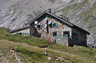
Refugio Elisabetta is a refuge in the Italian Alps at an altitude of 2,195 m, which provides a convenient overnight stage for walkers undertaking the Tour du Mont Blanc. It is located 3 km north-east of the Col de la Seigne, at the south-west end of the Mont Blanc massif, and provides good views of Mont Blanc and the Aiguille Noire de Peuterey. Because of its popularity, plus the fact that there are no other huts along this part of the Tour du Mont Blanc, walkers are advised to book in advance during the peak periods in July and August.

The Aiguille du Chardonnet is a mountain in the Mont Blanc massif in Haute-Savoie, France. It lies between the Glacier du Tour and the Glacier d'Argentière. The border with Switzerland runs just east of the summit.

The Aiguille du Jardin is a summit on the east ridge of Aiguille Verte in the Mont Blanc massif in Haute-Savoie, France.
Grande Rocheuse is a summit on the east ridge of Aiguille Verte in the Mont Blanc massif in Haute-Savoie, France

The Aiguille des Grands Charmoz is a mountain in the Mont Blanc Massif in Haute-Savoie, France.

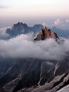
The Aiguille du Plan is a mountain in the Mont Blanc massif in the French Alps. Its needle-like summit lies in the centre of the Chamonix Aiguilles when viewed from Chamonix.

Jean-Marc Boivin was a French mountaineer, extreme skier, hang glider and paraglider pilot, speleologist, BASE jumper, award-winning film maker, and author. The holder of several altitude records for hang gliding and paragliding, the creator of numerous first ascents and first ski descents in the Alps, a member of the team that broke the record for a sub-glacial dive and the first person to paraglide from the summit of Mount Everest, Boivin was a pioneer of extreme sports. He died from injuries incurred after BASE jumping off Angel Falls in Venezuela, the highest waterfall in the world.

Armand Charlet was a French mountaineer and mountain guide.

Aiguille de Chambeyron (3,412m) is a mountain of the Cottian Alps and is the highest mountain of Alpes-de-Haute-Provence in southeast France. Together with its neighbour Brec de Chambeyron it is the dominant peak of the upper Ubaye Valley. The mountain is located near the border with Italy, just west of the Main chain of the Alps. It is the culminating point of the Massif du Chambeyron and is also the highest peak in the Alps south of Monte Viso.

Brec de Chambeyron (3,389) is a mountain of the Cottian Alps on the border between France and Italy. It is the second highest summit of the Chambeyron Massif, after Aiguille de Chambeyron and its sharp, rocky peak dominates the Upper Ubaye Valley. The word "Brec" or "Bric" in French is used for a mountain resembling a rocky tooth. It was first climbed in 1878 by Paul Agnel and Joseph Risoul.

The Aiguilles d'Entrèves is a mountain peak in the Mont Blanc massif of the Alps. It is situated at the head of the Glacier du Géant, and its rocky summit ridge forms part of the frontier between France and Italy. It lies east of the Tour Ronde, between the Col d'Entrèves and the Col Occidental de Toule. It has a steep, sound face of red granite and can be readily accessed from the Torino Hut/Pointe Helbronner.

The Aiguille de Toule is a mountain peak in the Mont Blanc massif of the Alps. Its summit is one of a number which form part of the mountainous frontier ridge between France and Italy which descends eastwards from Mont Blanc and continues towards the Grandes Jorasses and Mont Dolent.