
Hendersonville is a city in Henderson County, North Carolina, United States. It is 22 miles (35 km) south of Asheville and is the county seat of Henderson County. Like the county, the city is named for 19th-century North Carolina Supreme Court Chief Justice Leonard Henderson.

Loveland is a city in Hamilton, Clermont, and Warren counties in the southwestern part of the U.S. state of Ohio. Considered part of the Greater Cincinnati area, Loveland is located near exit 52 off Interstate 275, about 15 miles (24 km) northeast of the Cincinnati city limits. It borders Symmes, Miami and Hamilton Townships and straddles the Little Miami River. The population was 12,081 at the 2010 census and was estimated at 13,145 in 2019. Once a busy railroad town, Loveland is now a major stop along the Little Miami Scenic Trail.
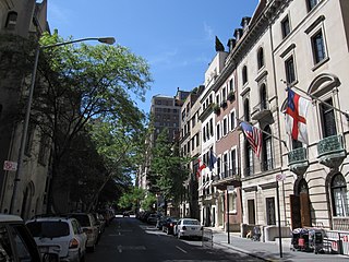
The Upper East Side, sometimes abbreviated UES, is a neighborhood in the borough of Manhattan in New York City, bounded by 96th Street to the north, the East River to the east, 59th Street to the south, and Central Park/Fifth Avenue to the west. The area incorporates several smaller neighborhoods, including Lenox Hill, Carnegie Hill, and Yorkville. Once known as the Silk Stocking District, it has long been one of the most affluent neighborhoods in New York City.

Fifth Avenue is a major thoroughfare in the borough of Manhattan in New York City. It stretches north from Washington Square Park in Greenwich Village to West 143rd Street in Harlem. It is considered one of the most expensive and elegant streets in the world.

Bowling Green is a station on the IRT Lexington Avenue Line of the New York City Subway, located at Broadway and Battery Place, in the Financial District of Manhattan. It is served by the 4 train at all times and the 5 train at all times except late nights.

Ridgewood is a neighborhood in the New York City borough of Queens. It borders the neighborhoods of Maspeth, Middle Village and Glendale, as well as the Brooklyn neighborhoods of Bushwick and East Williamsburg. Historically, the neighborhood straddled the Queens-Brooklyn boundary.

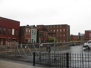
Woodbridge is a historic neighborhood of primarily Victorian homes located in Detroit, Michigan. The district was listed on the National Register of Historic Places in 1980, with later boundary increases in 1997 and 2008. In addition to its historic value, Woodbridge is also notable for being an intact neighborhood of turn-of-the-century homes within walking or biking distance of Detroit's Downtown, Midtown, New Center, and Corktown neighborhoods.
Ronald Reagan Cross County Highway, formerly and locally known as Cross County Highway, is a west-east freeway in Hamilton County, Ohio, United States. It stretches 16.4 miles (26.4 km) from southern Colerain Township to Montgomery, connecting many of Cincinnati's northern suburbs to Interstate 71 and Interstate 75. State Route 126 is routed over most of the highway, while the remainder is a county-maintained road.

The West Village is a neighborhood in the western section of the larger Greenwich Village neighborhood of Lower Manhattan, New York City.

The Dayton Street Historic District is located in the Old West End neighborhood of Cincinnati, Ohio, United States. It was once known as "Millionaires' Row" for the prominent industrialists who resided in a row of opulent mansions built between 1850 and 1890. It is bounded by Bank Street, Poplar Street, Linn Street, and Winchell Avenue. The district was designated and listed on the National Register of Historic Places on January 25, 1973.

Mount Morris Park Historic District was designated a historic district by New York City Landmarks Preservation Commission in 1971, and is part of the larger Mount Morris Park neighborhood. It is a large 16-block area in west central Harlem. The boundaries are West 118th and West 124th Streets, Fifth Avenue, and Adam Clayton Powell Jr. Boulevard. "Doctor's Row" comprises the nearby stretch of West 122nd Street, Mount Morris Park West and Malcolm X Boulevard; one of the doctors of "Doctor's Row" was the father of the composer Richard Rodgers. Mount Morris Square, the core of the district, is now called Marcus Garvey Park.

Downtown is a neighborhood of Washington, D.C., as well as a colloquial name for the central business district in the northwest quadrant of the city. Historically, the Downtown has been defined as an area east of 16th Street NW, north of the National Mall/US Capitol complex, and south of Massachusetts Avenue, including the Penn Quarter. However, the city says that most residents, workers, and visitors think of Downtown in a broader sense—including areas as far north as Dupont Circle, the Golden Triangle, as far west as Foggy Bottom, and as far east as Capitol Hill. A small portion of this area is known as the Downtown Historic District and was listed on the NRHP in 2001.

Mount Auburn Historic District is located in the Mount Auburn neighborhood of Cincinnati, Ohio. It extends along both sides of Auburn Avenue roughly between Ringold Street and William H. Taft Road. The population of Mount Auburn was 4,904 at the 2010 census.
Police Station Five was a historic police station in the West End neighborhood of Cincinnati, Ohio, United States. Constructed in the 1890s to serve both regular police and the city's patrol service, it was named a historic site in the late twentieth century, but historic designation was unable to save it from destruction.

The Henry Powell House is a historic house in the Mount Auburn neighborhood of Cincinnati, Ohio, United States. Constructed in the mid-19th century, it experienced a radical transformation near the end of the century under the direction of a leading regional architect. This French-style residence has been named a historic site.
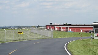
Clermont County Airport is a public use airport located two nautical miles west of the central business district of Batavia, a village in Clermont County, Ohio, United States. It is owned by the Clermont County Commissioners.

There are 69 properties listed on the National Register of Historic Places in Albany, New York, United States. Six are additionally designated as National Historic Landmarks (NHLs), the most of any city in the state after New York City. Another 14 are historic districts, for which 20 of the listings are also contributing properties. Two properties, both buildings, that had been listed in the past but have since been demolished have been delisted; one building that is also no longer extant remains listed.

The former Eighth Precinct Police Station is a building located at 4150 Grand River Avenue in the Woodbridge Historic District of Detroit, Michigan. It is the second-oldest police building in Detroit, and was designated a Michigan State Historic Site in 1973 and listed on the National Register of Historic Places in 1974. The building now houses the Detroit Castle Lofts.

The Greenwich Avenue Historic District is a historic district representing the commercial and civic historical development of the downtown area of the town of Greenwich, Connecticut. The district was listed on the National Register of Historic Places on August 31, 1989. Included in the district is the Greenwich Municipal Center Historic District, which was listed on the National Register the year before for the classical revival style municipal buildings in the core of Downtown. Most of the commercial buildings in the district fall into three broad styles, reflecting the period in which they were built: Italianate, Georgian Revival, and Commercial style. The district is linear and runs north–south along the entire length of Greenwich Avenue, the main thoroughfare of Downtown Greenwich, between U.S. Route 1 and the New Haven Line railroad tracks.

Lytle Park Historic District is a historic district in Cincinnati, Ohio, United States. Roughly bounded by 3rd, 5th, Sycamore, Commercial Sq., and Butler Sts. in downtown Cincinnati, it centers on Lytle Park.


