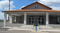
Ponta Grossa Airport

Last updated
Comte. Antonio Amilton Beraldo Airport

Aeroporto Comte. Antonio Amilton Beraldo
Building of Ponta Grossa Airport (PGZ), Parana, Brazil.jpg
Summary
Airport typePublic
Operator Ponta Grossa
SEIL
Serves Ponta Grossa
Time zone BRT (UTC−03:00)
Elevation  AMSL 789 m / 2,588 ft
Coordinates 25°11′04″S050°08′38″W / 25.18444°S 50.14389°W / -25.18444; -50.14389
Map
Brazil Parana location map.svg
Airplane silhouette.svg
PGZ
Location in Brazil
Brazil location map.svg
Airplane silhouette.svg
PGZ
PGZ (Brazil)
Ponta Grossa Airport
Runways
Direction LengthSurface
mft
08/261,4304,692 Asphalt
Statistics (2011)
Passengers1,979 Decrease2.svg 51%
Aircraft Operations3,657 Increase2.svg 52%
Statistics: SEIL [1] [2]
Sources: ANAC, [3] DECEA [4]

Comte. Antonio Amilton Beraldo Airport( IATA : PGZ, ICAO : SBPG), formerly SSZW and called Sant'Ana Airport, is the airport serving Ponta Grossa, Brazil.

Contents

It is operated by the Municipality of Ponta Grossa under the supervision of Aeroportos do Paraná (SEIL).

Airlines and destinations

No scheduled flights operate at this airport.

Accidents and incidents

Access

The airport is located 10 km (6 mi) south from downtown Ponta Grossa.

See also

References

  1. "Estatística de passageiros" (PDF) (in Portuguese). SEIL. March 2012. Retrieved 18 July 2020.
  2. "Movimentação de aeronaves" (PDF). SEIL (in Portuguese). March 2012. Retrieved 18 July 2020.
  3. "Aeródromos". ANAC (in Portuguese). 26 June 2020. Retrieved 22 April 2021.
  4. "Comandante Antônio Amilton Beraldo (SBPG)". DECEA (in Portuguese). Retrieved 31 March 2024.
  5. "Accident description PP-YQS". Aviation Safety Network. Retrieved 22 April 2021.