Potwin, Kansas

Last updated

Potwin, Kansas
Potwin water tower.JPG
Potwin water tower (2015)
Butler County Kansas Incorporated and Unincorporated areas Potwin Highlighted.svg
Location within Butler County and Kansas
Map of Butler Co, Ks, USA.png
Coordinates: 37°56′19″N97°01′06″W / 37.93861°N 97.01833°W / 37.93861; -97.01833 [1]
Country United States
State Kansas
County Butler
Founded1880s
Incorporated 1885
Named for Charles Potwin
Government
  Type Mayor–Council
   Mayor Adam Johnson [ citation needed ]
Area
[2]
  Total0.23 sq mi (0.61 km2)
  Land0.23 sq mi (0.61 km2)
  Water0.00 sq mi (0.00 km2)
Elevation
[1]
1,345 ft (410 m)
Population
 (2020) [3]
  Total421
  Density1,800/sq mi (690/km2)
Time zone UTC-6 (CST)
  Summer (DST) UTC-5 (CDT)
ZIP code
67123
Area code 620
FIPS code 20-57300
GNIS ID 2396263 [1]
Website potwinks.com

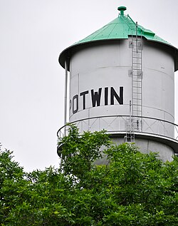
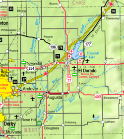
Potwin is a city in Butler County, Kansas, United States. [1] It is named after the town site land owner Charles Potwin. As of the 2020 census, the population of the city was 421. [3]

Contents

History

Early history

For many millennia, the Great Plains of North America was inhabited by nomadic Native Americans. From the 16th century to 18th century, the Kingdom of France claimed ownership of large parts of North America. In 1762, after the French and Indian War, France secretly ceded New France to Spain, per the Treaty of Fontainebleau.

19th century

In 1802, Spain returned most of the land to France. In 1803, most of the land for modern day Kansas was acquired by the United States from France as part of the 828,000 square mile Louisiana Purchase for 2.83 cents per acre.

In 1854, the Kansas Territory was organized, then in 1861 Kansas became the 34th U.S. state. In 1855, Butler County was established within the Kansas Territory, which included the land for modern day Potwin.

Potwin was incorporated as a town on April 8, 1885. This land, owned by Charles Potwin, whereby the town received its name, became a station for the Missouri Pacific Railroad, instigated by William I. Joseph, known as the Father of Potwin. [4]

Joseph came from West Virginia and, as more settlers arrived, became interested in a railroad to serve the area. After much diligent pursuit, the station was built and Joseph, a land agent for Charles Potwin, began development of a town site around the Potwin station. He opened a land office where the Potwin grocery now stands. [4]

A post office was established in Ayr (an extinct town) on July 12, 1875, but it was moved to Potwin on September 22, 1885. [5] [6]

It quickly grew, including some businesses and houses from nearby community of Plum Grove. [7]

20th century

381st Strategic Missile Wing Titan II intercontinental ballistic missile sites 381st SMW Titan II Missile Sites.png
381st Strategic Missile Wing Titan II intercontinental ballistic missile sites

During half of the twentieth century, Potwin enjoyed the prosperity of oil fields in the Mid-Continent oil province. In 1920, John (Jack) Vickers (1891-1940) built the Vickers Oil Refinery in Potwin. He got his start in oil fields in Butler County, commencing with the lease on the Parris Farm 10 miles north of Potwin, production reached 16,000 barrels a day during the 1950s. In 1964, distressed economic conditions shut down the oil processing facilities. The company was sold to Swift & Company and the remaining operations were closed in 1970, [4] and later demolished. In 1934, Vickers built a large mansion (named "Vickridge") east of Wichita (now in the city limits), which his estate later become the current site of Kapaun Mt. Carmel High School. [8]

In 1961, Frederic Remington High School was built immediately north of Brainerd. Leading up to this new school, Whitewater, Potwin, Brainerd, Elbing, Furley, Countryside, and Golden Gate schools merged to form a joint rural high school. Heated opposition between Whitewater and Potwin occurred during the discussion for the location of the new high school. Rural voters pushed for a centralized location in neither town. A public vote was passed to build the new school near Brainerd. [9]

From 1960s to 1980s, a Titan II intercontinental ballistic missile site was located north of Potwin. The site was one of eighteen overseen by the 381st Strategic Missile Wing at McConnell Air Force Base in Wichita, Kansas. The Titan II near Potwin likely contained a 9 megaton W-53 nuclear warhead.

21st century

In 2010, the Keystone-Cushing Pipeline (Phase II) was constructed along the east city limits of Potwin, north to south through Butler County, with much controversy over tax exemption and environmental concerns (if a leak ever occurs). [10] [11] A pumping station named Burns was built 2 miles north of Potwin, and new power lines were built from a high-voltage line 0.3 mile east of De Graff. [12]

In an unusual technical glitch, a farmstead about 4 miles northeast of Potwin became the default geolocation of 600 million IP addresses when the Massachusetts-based digital mapping company MaxMind changed the putative geographic center of the contiguous United States from 39.8333333,-98.585522 to 38.0000,-97.0000. [13] [14]

Geography

According to the United States Census Bureau, the city has a total area of 0.24 square miles (0.62 km2), all of it land. [15]

Climate

The climate in this area is characterized by hot, humid summers and generally mild to cool winters. According to the Köppen Climate Classification system, Potwin has a humid subtropical climate, abbreviated "Cfa" on climate maps. [16]

Demographics

Historical population
CensusPop.Note
1910 249
1920 41566.7%
1930 4272.9%
1940 48714.1%
1950 465−4.5%
1960 63536.6%
1970 497−21.7%
1980 56313.3%
1990 448−20.4%
2000 4572.0%
2010 449−1.8%
2020 421−6.2%
U.S. Decennial Census

2010 census

As of the census [17] of 2010, there were 449 people, 181 households, and 130 families residing in the city. The population density was 1,870.8 inhabitants per square mile (722.3/km2). There were 205 housing units at an average density of 854.2 per square mile (329.8/km2). The racial makeup of the city was 92.2% White, 0.2% African American, 1.3% Native American, 0.7% Asian, 2.2% from other races, and 3.3% from two or more races. Hispanic or Latino of any race were 5.6% of the population.

There were 181 households, of which 30.4% had children under the age of 18 living with them, 55.8% were married couples living together, 9.9% had a female householder with no husband present, 6.1% had a male householder with no wife present, and 28.2% were non-families. 24.9% of all households were made up of individuals, and 11.1% had someone living alone who was 65 years of age or older. The average household size was 2.48 and the average family size was 2.94.

The median age in the city was 39.4 years. 25.2% of residents were under the age of 18; 8.2% were between the ages of 18 and 24; 24.1% were from 25 to 44; 28.5% were from 45 to 64; and 14% were 65 years of age or older. The gender makeup of the city was 49.9% male and 50.1% female.

2000 census

As of the census [18] of 2000, there were 457 people, 187 households, and 123 families residing in the city. The population density was 2,001.1 inhabitants per square mile (772.6/km2). There were 208 housing units at an average density of 910.8 per square mile (351.7/km2).

The racial makeup of the city was 95.40% White, 1.53% Native American, 0.22% Asian, and 2.84% from two or more races. Hispanic or Latino of any race were 0.88% of the population.

There were 187 households, out of which 33.2% had children under the age of 18 living with them, 53.5% were married couples living together, 8.0% had a female householder with no husband present, and 34.2% were non-families. 28.3% of all households were made up of individuals, and 17.1% had someone living alone who was 65 years of age or older. The average household size was 2.44 and the average family size was 2.95.

In the city, the population was spread out, with 26.0% under the age of 18, 9.0% from 18 to 24, 28.0% from 25 to 44, 21.9% from 45 to 64, and 15.1% who were 65 years of age or older. The median age was 37 years. For every 100 females, there were 100.4 males. For every 100 females age 18 and over, there were 94.3 males.

The median income for a household in the city was $39,091, and the median income for a family was $42,500. Males had a median income of $31,544 versus $18,375 for females. The per capita income for the city was $18,254. About 4.7% of families and 8.3% of the population were below the poverty line, including 6.8% of those under age 18 and 8.6% of those age 65 or over.

Education

The community is served by Remington USD 206 public school district. The Remington High School mascot is a Bronco.

Potwin High School was closed through school unification. The Potwin High School mascot was Greyhounds. [19]

Media

Print

Radio

Potwin is served by numerous radio stations of the Wichita-Hutchinson listening market area, [20] and satellite radio. See Media in Wichita, Kansas .

Television

Potwin is served by over-the-air ATSC digital TV of the Wichita-Hutchinson viewing market area, [21] cable TV, and satellite TV. See Media in Wichita, Kansas .

Infrastructure

Transportation

K-196 highway runs along the south side of the city.

See also

Related Research Articles

<span class="mw-page-title-main">Washington County, Kansas</span> County in Kansas, United States

Washington County is a county located in the U.S. state of Kansas. Its county seat and largest city is Washington. As of the 2020 census, the county population was 5,530. The county was named for George Washington, the 1st president of the United States.

<span class="mw-page-title-main">Marion County, Kansas</span> County in Kansas, United States

Marion County is a county located in the U.S. state of Kansas. Its county seat is Marion and its most populous city is Hillsboro. As of the 2020 census, the county population was 11,823. The county was named in honor of Francis Marion, a brigadier general of the American Revolutionary War, known as the "Swamp Fox".

<span class="mw-page-title-main">Dickinson County, Kansas</span> County in Kansas, United States

Dickinson County is a county in Central Kansas. Its county seat and most populous city is Abilene. As of the 2020 census, the county population was 18,402. The county was named in honor of Daniel Dickinson, a U.S. Senator from New York that was a Kansas statehood advocate.

<span class="mw-page-title-main">Butler County, Kansas</span> County in Kansas, United States

Butler County is a county in the U.S. state of Kansas and is the largest county in the state by total area. Its county seat is El Dorado and its most populous city is Andover. As of the 2020 census, the county population was 67,380. The county was named for Andrew Butler, a U.S. Senator from South Carolina who coauthored the Kansas–Nebraska Act.

<span class="mw-page-title-main">Andover, Kansas</span> City in Butler County, Kansas

Andover is a city in Butler County, Kansas, United States, and a suburb of Wichita. As of the 2020 census, the population of the city was 14,892. Andover is the most populated city in Butler County.

<span class="mw-page-title-main">Augusta, Kansas</span> City in Butler County, Kansas

Augusta is a city in Butler County, Kansas, United States. As of the 2020 census, the population of the city was 9,256.

<span class="mw-page-title-main">El Dorado, Kansas</span> City in Butler County, Kansas

El Dorado is city and county seat of Butler County, Kansas, United States. It is situated along the Walnut River in the central part of Butler County and located in south-central Kansas. As of the 2020 census, the population of the city was 12,870. It is home to Butler Community College.

<span class="mw-page-title-main">Elbing, Kansas</span> City in Butler County, Kansas

Elbing is a city in Butler County, Kansas, United States. It is named after the city Elbląg in northern Poland, formerly Prussia. As of the 2020 census, the population of the city was 226. It is located about 10.7 miles east of Interstate 135 in Newton, along the Union Pacific Railroad.

<span class="mw-page-title-main">Towanda, Kansas</span> City in Butler County, Kansas

Towanda is a city in Butler County, Kansas, United States. As of the 2020 census, the population of the city was 1,447.

<span class="mw-page-title-main">Whitewater, Kansas</span> City in Butler County, Kansas

Whitewater is a city in Butler County, Kansas, United States. As of the 2020 census, the population of the city was 661.

<span class="mw-page-title-main">Burns, Kansas</span> City in Marion County, Kansas

Burns is a city in Marion County, Kansas, United States. As of the 2020 census, the population of the city was 234. The city name came from a nearby train station, which was named prior to the city being incorporated. It is located between El Dorado and Florence along the west side of U.S. Route 77 highway. The south edge of the city is the border of Marion and Butler counties.

<span class="mw-page-title-main">Goessel, Kansas</span> City in Marion County, Kansas

Goessel is a city in Marion County, Kansas, United States. As of the 2020 census, the population of the city was 556. The city was named after Captain Kurt von Goessel (1852–1895) who went down with his ship, the Elbe, in the English Channel after it was rammed. It is located about 11 miles north of North Newton on the west side of K-15 highway.

<span class="mw-page-title-main">Ramona, Kansas</span> City in Marion County, Kansas

Ramona is a city in Marion County, Kansas, United States. As of the 2020 census, the population of the city was 78. The city name is a Spanish name. It is located southwest of Herington next to a railroad.

<span class="mw-page-title-main">Haysville, Kansas</span> City in Sedgwick County, Kansas

Haysville is a city in Sedgwick County, Kansas, United States, and a suburb of Wichita. As of the 2020 census, the population of the city was 11,262. Haysville is known as the "Peach Capital of Kansas".

<span class="mw-page-title-main">Wichita metropolitan area, Kansas</span> Metropolitan area in the United States

The Wichita, KS Metropolitan Statistical Area, as defined by the United States Office of Management and Budget, is an area consisting of four counties in south central Kansas, it’s only principal city is Wichita and it’s only central county is Sedgwick County. As of the 2013 American Community Survey, the MSA had a population of 637,989.

<span class="mw-page-title-main">Frederic Remington High School</span> High school in Whitewater, Kansas, United States

Frederic Remington High School is a public secondary school in rural Butler County, Kansas between the cities of Whitewater and Potwin. It is located north of K-196 highway, along the north side of the unincorporated community of Brainerd and southeast of the intersection of NW Meadowlark Rd and NW 90th St. It is one of three schools operated by Remington USD 206 public school district. This school is also commonly known as Remington High School as the shorter name, and Whitewater-Remington High School on KSHSAA sport lists.

<span class="mw-page-title-main">Brainerd, Kansas</span> Unincorporated community in Butler County, Kansas

Brainerd is an unincorporated community in Butler County, Kansas, United States. It is located on the north side of K-196 highway between the cities of Whitewater and Potwin.

<span class="mw-page-title-main">Furley, Kansas</span> Unincorporated community in Sedgwick County, Kansas

Furley is an unincorporated community in Sedgwick County, Kansas, United States. As of the 2020 census, the population of the community and nearby areas was 39. It is located northwest of the intersection of Greenwich Road and 101st Street N, along the Union Pacific Railroad.

<span class="mw-page-title-main">Plum Grove, Kansas</span> Ghost town in Kansas, United States

Plum Grove is a ghost town in Butler County, Kansas, United States. It was located in a rural area north of modern-day Potwin. No buildings remain at this former community site.

Remington USD 206 is a public unified school district headquartered in Whitewater, Kansas, United States. Depending on the historic use, it may also have the word "Whitewater" either before or after "Remington". The district includes the communities of Whitewater, Potwin, Brainerd, Elbing, Furley, and nearby rural areas in Butler, Harvey, Sedgwick counties.

References

  1. 1 2 3 4 U.S. Geological Survey Geographic Names Information System: Potwin, Kansas
  2. "2019 U.S. Gazetteer Files". United States Census Bureau. Retrieved July 24, 2020.
  3. 1 2 "Profile of Potwin, Kansas in 2020". United States Census Bureau. Archived from the original on November 12, 2021. Retrieved November 12, 2021.
  4. 1 2 3 "The History of Potwin, Kansas". www.skyways.org. Archived from the original on May 26, 2003.
  5. "Kansas Post Offices, 1828-1961 (archived)". Kansas Historical Society. Archived from the original on October 9, 2013. Retrieved June 5, 2014.
  6. "Kansas Post Offices, 1828-1961, page 2 (archived)". Kansas Historical Society. Archived from the original on October 9, 2013. Retrieved June 5, 2014.
  7. "New town of Brainerd and Potwin". The Peabody Gazette. June 11, 1885. p. 4 via peabody.advantage-preservation.com.
  8. "Tihen Notes Subject Search Vickers,vickridge" (PDF). Wichita State University Libraries’ Department Of Special Collections. Retrieved March 19, 2015.
  9. "USD 206". www.usd206.org.
  10. Keystone Pipeline - Marion County Commission calls out Legislative Leadership on Pipeline Deal; April 18, 2010. Archived October 22, 2011, at the Wayback Machine
  11. Keystone Pipeline - TransCanada inspecting pipeline; December 10, 2010.
  12. "Cardno - English (Australia) - Home" (PDF). www.entrix.com.
  13. Hill, Kashmir (April 10, 2016). "How an internet mapping glitch turned a random Kansas farm into a digital hell". Fusion. Retrieved April 10, 2016.
  14. "Kansas couple sues over internet glitch targeting their home". kansas.com. August 8, 2016.
  15. "US Gazetteer files 2010". United States Census Bureau. Archived from the original on July 2, 2012. Retrieved July 6, 2012.
  16. "Potwin, Kansas Köppen Climate Classification (Weatherbase)". Weatherbase.
  17. "U.S. Census website". United States Census Bureau . Retrieved July 6, 2012.
  18. "U.S. Census website". United States Census Bureau . Retrieved January 31, 2008.
  19. "Potwin High School". E-YEARBOOK.COM. Retrieved January 10, 2017.
  20. dvprez. "Radio Stations in Wichita KS". www.ontheradio.net.
  21. "Wichita - Hutchinson Television Stations - Station Index". www.stationindex.com.

Further reading