Related Research Articles

The Srinagar District is one of the 20 districts of the Indian union territory of Jammu and Kashmir. Situated in the centre of the Kashmir Valley, it is the second-most populous district of the union territory after Jammu District as per the 2011 national census, and is home to the summer capital city of Srinagar. Likewise, the city of Srinagar also serves as the Srinagar District's headquarters.

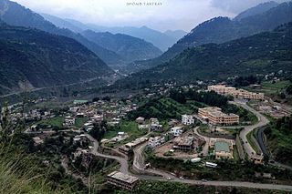
The Pulwama district is located to the south of Srinagar in Indian-administered Kashmir. Its district headquarters are situated in the city of Pulwama. It is located in the central part of the Kashmir Valley.
Pulwama is a City and notified area council in the Pulwama district of the Indian-administered territory of Jammu and Kashmir. It is located approximately 25 kilometres (16 mi) south of the summer capital of Srinagar.

Poonch or Punch is a district in the Jammu Division of Jammu and Kashmir, India. With headquarters in the town of Poonch, it is bounded by the Line of Control on three sides. The 1947-48 war between India and Pakistan divided the earlier district into two parts. One went to Pakistan and the other became part of the then Indian state of Jammu and Kashmir.
Kupwara is a town and a municipal council in Kupwara district in the Indian union territory of Jammu and Kashmir.

Kupwara district is one of the 10 districts located in the Kashmir Valley Division of Indian administered Kashmir. The talri river( originating in lolab valley and flowing from east to west) and Mawar river are two main rivers in the district. Both of them meet Jhelum river in Baramulla district.

Budgam district is a district in the Indian-administered union territory of Jammu and Kashmir. Created in 1979 with its headquarters at Budgam, it is the district with the largest population of Shias in the Kashmir valley.
Ramban is a district in the Indian union territory of Jammu and Kashmir, located in the lap of the Pir Panjal range. It was carved out as a separate district from erstwhile Doda district in 2007. It is located in the Jammu division. The district headquarters are at Ramban town, which is located midway between Jammu and Srinagar along the Chenab river in the Chenab valley on National Highway-44, approximately 151 km from Jammu and Srinagar.
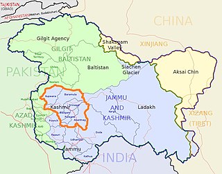
The Kashmir division is a revenue and administrative division of the Indian-administered Jammu and Kashmir. It comprises the Kashmir Valley, bordering the Jammu Division to the south and Ladakh to the east. The Line of Control forms its boundary with the Pakistani-administered territories of Gilgit−Baltistan and Azad Jammu and Kashmir to the north and west and west, respectively.

Akingam is a village in South Kashmir in the Anantnag district, in the Indian union territory of Jammu and Kashmir. It is at a distance of approximately 14.2 kilometres (8.8 mi) from the Lal Chowk along a route passing through the tourist resorts of Achabal and Kokernag. In revenue records, the village of Akingam is still called Maqan Shiva Bhagwati. The adjacent villages are Mohripura, Hiller, Badasgam, Hardpora and Badoora.
Budgam, known as Badgom in Kashmiri, is a town in Budgam district in the union territory of Jammu and Kashmir, India. In the 2001 census, it was recorded as having a notified area committee, but by the 2011 census it had a municipal committee.Arath Budgam is the second largest Village of Budgam(Ever Green Public Model School Arath is the popular school in this village).
Dooniwari or Dooniwara is a village in Budgam district of the Indian union territory of Jammu and Kashmir, situated 13 km (8.1 mi) away from Srinagar city and 18 km (11 mi) away from Budgam town. The total geographical area of village is 168 ha. Dooniwari has a total population of 1,839 citizens. There are about 278 houses in Dooniwari village as per 2011 census. Areas in its locality include Wathoora, Gopalpora, Chattergam, Kralapora and Bagati Kani Pora.
Zoonipora is a medium size village in the locality of Dooniwari, located in BAGAT KANIPORA Tehsil of Budgam district, Jammu and Kashmir with total 57 families residing. The Zooni Pora village has population of 471 of which 237 are males while 234 are females as per Population Census 2011.
Narwara Beerwah is a village in tehsil Beerwah of district Budgam of the Jammu and Kashmir.
Ohangam is a village in tehsil Beerwah of district Budgam of the Jammu and Kashmir. its population is about 3500. The famous Kashmiri poet and the author of Kashmiri folktale Heemal Nagrai, Waliullah Mattu is from the same village. The shrine of famous sufi saint Baba Hanief Ud Din Reshi is lacated in the North East of Ohangam.
Otligam is a village in tehsil Beerwah of district Budgam of the Jammu and Kashmir.. Village plays an important role with respect to education, banking facilities as well as the road connectivity of adjoining villages. Besides this the village has a Primary Health Centre set by Ministry of Ayush.
Gondipora is a village in tehsil Beerwah of district Budgam of the Jammu and Kashmir.
Tail Wani, commonly known as Tailwani, is a village in Anantnag tehsils in Anantnag district, Jammu and Kashmir, India. Tail Wani village is located in Anantnag Tehsil of Anantnag district in Jammu & Kashmir. It is situated 17 km away from Anantnag.
Majalta is a Town and Tehsil in Udhampur district, Jammu and Kashmir, India.
Amara is a village in Udhampur district, Jammu & Kashmir, India. It is located 15 km away from Majalta tehsil.
References
- ↑ "The Jammu and Kashmir Official Languages Act, 2020" (PDF). The Gazette of India. 27 September 2020. Retrieved 27 September 2020.
- ↑ "Parliament passes JK Official Languages Bill, 2020". Rising Kashmir. 23 September 2020. Retrieved 30 May 2021.
- ↑ "Census of India: Search Details". censusindia.gov.in. Retrieved 6 August 2021.
- ↑ Registrar, India Office of the; General, India Office of the Registrar (1972). Census of India, 1971: Series 8: Jammu & Kashmir. Manager of Publications.
| Subdivisions | |
|---|---|
| Municipalities | |
| Tehsils | |
| Blocks | |
| Tourist attractions | |
| Villages | |
| Railway | |
| Airport | |