
Puget Sound is a complex estuarine system of interconnected marine waterways and basins located on the northwest coast of the U.S. state of Washington. As a part of the Salish Sea, the sound has one major and two minor connections to the Strait of Juan de Fuca, which in turn connects to the open Pacific Ocean. The major connection is Admiralty Inlet; the minor connections are Deception Pass and the Swinomish Channel.

Pierce County is a county in the U.S. state of Washington. As of the 2020 census, the population was 921,130, up from 795,225 in 2010, making it the second-most populous county in Washington, behind King County, and the 59th-most populous in the United States. The county seat and largest city is Tacoma. Formed out of Thurston County on December 22, 1852, by the legislature of Oregon Territory, it was named for U.S. President Franklin Pierce. Pierce County is in the Seattle metropolitan area.
DuPont is a city in Pierce County, Washington, United States. The population was 10,151 at the 2020 census. Originally a company town, the city is named after the DuPont chemical company which operated an explosives manufacturing plant in the area from 1909 to 1975.
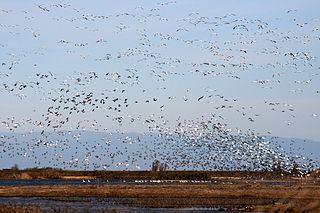
The Sacramento National Wildlife Refuge Complex is part of the United States system of National Wildlife Refuges (NWR). It is located in northern California, in the valley of the Sacramento River.
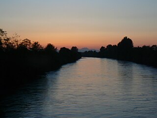
The Puyallup River is a river in the U.S. state of Washington. About 45 miles (72 km) long, it is formed by glaciers on the west side of Mount Rainier. It flows generally northwest, emptying into Commencement Bay, part of Puget Sound. The river and its tributaries drain an area of about 948 square miles (2,460 km2) in Pierce County and southern King County.

The Nisqually River is a river in west central Washington in the United States, approximately 81 miles (130 km) long. It drains part of the Cascade Range southeast of Tacoma, including the southern slope of Mount Rainier, and empties into the southern end of Puget Sound. Its outlet was designated in 1971 as the Nisqually Delta National Natural Landmark.
Preserve Our Islands is a grassroots organization, created by Senator Sharon Nelson and residents of Maury Island, Washington, United States, that is opposed to Glacier Northwest and their efforts to mine aggregate on Maury Island.

Matthews Beach is a neighborhood in Seattle, Washington; it and Meadowbrook are the southern neighborhoods of the annexed township of Lake City (1954). Matthews Beach lies about 2 miles (3.2 km) northeast of the University of Washington, about 8 miles (13 km) northeast of Downtown.

Fort Nisqually was an important fur trading and farming post of the Hudson's Bay Company in the Puget Sound area, part of the Hudson's Bay Company's Columbia Department. It was located in what is now DuPont, Washington. Today it is a living history museum located in Tacoma, Washington, USA, within the boundaries of Point Defiance Park. The Fort Nisqually Granary, moved along with the Factor's House from the original site of the second fort to this park, is a U.S. National Historic Landmark. Built in 1843, the granary is the oldest building in Washington state and one of the only surviving examples of a Hudson's Bay Company "post-and-plank" structure. The Factor's House and the granary are the only surviving Hudson's Bay Company buildings in the United States.

The Billy Frank Jr. Nisqually National Wildlife Refuge is a wildlife preserve operated by the United States Fish and Wildlife Service on the Nisqually River Delta near Puget Sound in northeastern Thurston County, Washington and northwestern Pierce County, Washington. The refuge is located just off Interstate 5, between the cities of Tacoma and Olympia.

Quarry Lakes Regional Recreation Area is a regional park located in Fremont, California that is part of the East Bay Regional Parks system. Before being converted into a park, the site was used as a gravel quarry. When water purchased by the public for groundwater recharge of the Niles Cone flooded the gravel pits, the gravel harvesters began to daily pump the seeping water down Alameda Creek into San Francisco Bay. The Alameda County Water District acquired the quarry after the pumping was declared to be an illegal waste in 1976.
The environmental issues on Maury Island are linked to broader Puget Sound environmental issues, which include concerns regarding declining salmon and forage fish populations, degrading critical marine and shoreline habitats, and threatened species such as the Orca.

The Hammar Marshes are a large wetland complex in southeastern Iraq that are part of the Mesopotamian Marshes in the Tigris–Euphrates river system. Historically, the Hammar Marshes extended up to 4,500 km2 (1,700 sq mi) during seasonal floods. They were destroyed during the 1990s by large-scale drainage, dam and dike construction projects. Since 2003, they are recovering following reflooding and destruction of dams.
Kazan Wildland Provincial Park is a wildland provincial park in northern Alberta, Canada. It was established on 14 May 2018 and is a large park with an area of 659,397 hectares (2,546 sq mi). As of January 2023, Kazan is the largest park under Alberta provincial authority. The park was initiated by and is contained in the Lower Athabasca Regional Plan Land Use Framework in August 2012. Two smaller parks, La Butte Creek and Colin-Cornwall Lakes Wildland Provincial Parks, were disestablished and incorporated into Kazan.
Leque Island is a small island located in Snohomish County, in Washington, United States. It can be found just beneath the bridge between Camano Island and Stanwood, at the mouth of the Stillaguamish River, in Puget Sound.

Echo Lake is a small lake in the Flathead Valley in the U.S. state of Montana. It is located five miles from Bigfork and 25 miles from Kalispell. The lake is filled with groundwater and a small amount of mountain runoff from Echo Creek, making it one of the warmest lakes in the Flathead Valley. The lake is next to the Swan Range and the Jewel Basin hiking area. Echo Lake also is connected to two smaller lakes, Abbot Lake and Peterson Lake, by a canal.

Lake Nisqually is used to identify the freshwater lake formed in the Puget Sound trough, west of Tacoma. It is sometime confused with Early Lake Russell which covered the same area during a previous northward retreat of the glacier. The glacier returned southward, then on its final retreat northward, the waters filing this basin are referred to as Lake Nisqually. Its discharge was across the Black Lake channel at 160 feet (49 m) above sea level. Two deltas formed along the eastern margin of the lake from the outflow of Lake Tacoma in the Puyallup River valley. Both the Steilacoom and Sequalichew deltas, at 160 feet (49 m). A rise in level to 180 to 200 feet reflects the closure of the Black Lake outlet while the two deltas were still growing.
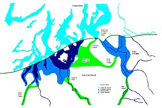
During the Vashon Glaciation a series of lakes formed along the southern margin of the Cordilleran Ice Cap. In the Puget Sound depression, a series of lakes developed, of which Lake Russell was the largest and the longest lasting. Early Lake Russell’s surface was at 160 ft (49 m) above sea level, draining across the divide at Shelton, Washington into early Glacial Lake Russell. When the ice margin receded northward, the lake expanded. When it reached the Clifton channel outlet, the water levels dropped to 120 ft (37 m) above sea level. The new longer and lower level lake is referred to as Lake Hood. The glacier continued to retreat until the northern outlet of the Hood Canal was reached as the water level equalized with Glacial Lake Russell becoming part of that body of water.
Sturgeon Bay Provincial Park is a provincial park on the western shore of Lake Winnipeg in Manitoba, Canada. The park is considered to be a Class Ib protected area under the IUCN protected area management categories. It is 144.9 km2 (55.9 sq mi) in size.


