
Çorum is a province in the Black Sea Region of Turkey, but lying inland and having more characteristics of Central Anatolia than the Black Sea coast. Its provincial capital is the city of Çorum, the traffic code is 19.

Bolu Province is a province situated in north-western Turkey. It is located between the capital, Ankara and the largest city in the country, Istanbul. It covers an area of 7,410 km2 and the population is 311,810.
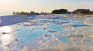
Denizli Province is a province of Turkey in Western Anatolia, on high ground above the Aegean coast. Neighbouring provinces are Uşak to the north, Burdur, Isparta, Afyon to the east, Aydın, Manisa to the west and Muğla to the south. It is located between the coordinates 28° 30’ and 29° 30’ E and 37° 12’ and 38° 12’ N. It covers an area of 11,868 km2, and the population is 931,823. The population was 750,882 in 1990. The provincial capital is the city of Denizli.
Tokat Province is a province in northern Turkey. Its adjacent provinces are Amasya to the northwest, Yozgat to the southwest, Sivas to the southeast, and Ordu to the northeast. Its capital is Tokat, which lies inland of the middle Black Sea region, 422 kilometers from Ankara.
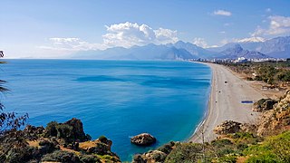
Antalya Province is located on the Mediterranean coast of south-west Turkey, between the Taurus Mountains and the Mediterranean Sea.

Kütahya Province is a province in the Aegean region of Turkey. It is 11,875 km2 in size, and the population is 571,554 (2014). In 1990, Kütahya had a population of 578,000.

Bulancak is a town in Giresun Province on the Black Sea coast of Turkey, near the city of Giresun. Its former name is Terastios. It is the seat of Bulancak District. Its population is 49,053 (2022).

Çamlıyayla is a town and district of Mersin Province in the Mediterranean region of Turkey. The district has a population of 10,558 of which 3335 lives in the town of Çamlıyayla.

Finike, the ancient Phoenix or Phoinix, also formerly Phineka, is a municipality and district of Antalya Province, Turkey. Its area is 768 km2, and its population is 49,720 (2022). It lies on the Mediterranean coast of Antalya Province in Turkey, to the west of the city of Antalya, along the Turkish Riviera. It is located on the southern shore of the Teke peninsula, and the coast here is a popular tourist destination. However, Finike is best known for its oranges, the symbol of the town.

Honaz is a town and a district of Denizli Province in the Aegean Region, also known as Khonaz or Cadmus. It covers an area of 504 km2 (195 sq mi). The population was 9,830 and 30,530.

İskilip is a district of Çorum Province, Turkey, on the left bank of the River Kızılırmak, located at 56 km from the city of Çorum, 100 miles northeast of Ankara and 60 miles southeast of Kastamonu. It is the seat of İskilip District. Its population is 17,612 (2022). The mayor is Ali Sülük.
Taşova is a town in Amasya Province of the central Black Sea region of Turkey. It is the seat of Taşova District. Its population is 11,248 (2021). The altitude of the town is 230 meters. The mayor is Bayram Öztürk (AKP).

Yeşilhisar, formerly known as Kbistra, is a town and district of Kayseri Province in the Central Anatolia region of Turkey.

Acıpayam is a municipality and district of Denizli Province, Turkey. Its area is 1,772 km2, and its population is 54,888 (2022). It lies in high country between the Aegean and Mediterranean regions. A plain, watered by two reservoirs, known for growing melons and watermelons, on the road between the city of Denizli and Antalya. Its altitude is 895 m.
Kale is an attractive rural district of Denizli Province of Turkey near the town of Tavas. Kale is a 45-minute drive from Denizli on the road from the city of Denizli to the Aegean city of Muğla. The mayor is İsmail Yarımca (MHP).

Silvan is a city and district in the Diyarbakır Province of Turkey. Its population is 41,451.

Beypazarı is a municipality and district of Ankara Province, Turkey. Its area is 1,697 km2, and its population is 48,357 (2022). It is approximately 100 km west of the city of Ankara. The elevation in the center is 675 m (2,215 ft). It used to be an important city in Asia Minor in ancient times.

Bafra is a district of Samsun Province of Turkey. It is a settlement located 20 kilometres (12 mi) from the Black Sea, in the fertile delta of the Kızılırmak River. The Bafra Plain is famous in Turkey for its rich soil and high quality tobacco growing conditions. The city is well known in Turkey for its ice cream, cigarettes, tobacco and agricultural produce. In 2020, the district reported a population of 143,366. The city is located 52 km northwest of Samsun and is connected by State road D.010.
Kışlak is a small town in Hatay Province, Turkey
Arifiye is a district center of Sakarya Province, Turkey. It is also included in Greater Sakarya Proper.


