Korab is the highest peak of the eponymous mountain range and the fourth-highest mountain located entirely in the Balkan Peninsula, standing at 2,764 metres.

The Mist Trail is one of the most popular short hikes in Yosemite National Park, California, USA. The steep hike follows the Merced River, starting at Happy Isles in Yosemite Valley, past Vernal Fall and Emerald Pool, to Nevada Fall.
Bjelašnica is a mountain in the Dinaric Alps in central Bosnia and Herzegovina. It is to the southwest of Sarajevo, bordering Mount Igman. Bjelašnica's tallest peak, by which the mountain group got its name, rises to an elevation of 2,067 metres (6,781 ft). Other notable peaks are Krvavac, Mali Vlahinja, and Hranisava. The Bjelašnica range is bordered by the Rakitnica in the south, the Neretva in the west, Mount Igman in the north-east and Mount Ivan in the north-west. Only at 20 minutes distance of Sarajevo, it is a tourist attraction for hiking and skiing.

Trebević is a mountain in central Bosnia and Herzegovina, located in the territories of Sarajevo and East Sarajevo city, bordering Jahorina mountain. Trebević is 1,627 meters (5,338 ft) tall, making it the second shortest of the Sarajevo mountains.

Nevada Fall is a 594-foot (181 m) high waterfall on the Merced River in Yosemite National Park, California. It is located below the granite dome, Liberty Cap, at the west end of Little Yosemite Valley. The waterfall is widely recognized by its "bent" shape, in which the water free-falls for roughly the first third of its length to a steep slick-rock slope. This mid-fall impact of the water on the cliff face creates a turbulent, whitewater appearance in the fall and produces a great deal of mist which covers a wide radius, which led to its current name.

The Sipsey Wilderness lies within Bankhead National Forest around the Sipsey Fork of the Black Warrior River in northwestern Alabama, United States. Designated in 1975 and expanded in 1988, 24,922-acre (10,086 ha) Sipsey is the largest and most frequently visited Wilderness area in Alabama and contains dozens of waterfalls. It was also the first designated wilderness area east of the Mississippi River.

The Sutjeska National Park is a national park located in Bosnia and Herzegovina. Established in 1962, it is Bosnia and Herzegovina's oldest national park. It includes the country's highest peak of Maglić, at over 2,386 metres (7,828 ft), on the border with Montenegro. The Montenegrin part of Maglić massif in the park has also formed the Trnovačko Jezero. The Strict Nature Reserve "Perućica", one of the last two remaining primeval forests in Europe, is part of the park. The park is also famous as being the location of the Battle of the Sutjeska in 1943 during World War II. It is an affiliated member of EUROPARC Federation.

Kamešnica is a mountain in the Dinaric Alps, located in the southern end of the Dinara Mountain Range on the border between Bosnia and Herzegovina and Croatia (Dalmatia). It is 1,851 metres (6,073 ft) high and stretches from the northwest white road pass Vaganj (1,173 m) to the Buško Blato artificial lake. The tallest peak is Konj (Horse) 1,855 metres (6,086 ft), which is located in Bosnia and Herzegovina and offers views of both sides of the border. In clear weather, it is possible to see the most remote areas of the Adriatic Sea and its islands. The vicinity's many trails and caves make it popular with hikers.

Baščaršija is Sarajevo's old bazaar and the historical and cultural center of the city. Baščaršija was built in the 15th century when Isa-Beg Ishaković founded the city.

Olovo is a town and municipality located in the Zenica-Doboj Canton of the Federation of Bosnia and Herzegovina, an entity of Bosnia and Herzegovina. It is situated about 50 kilometers northeast of the capital city of Sarajevo and is located on the road between Sarajevo and Tuzla.

Tourism in Bosnia and Herzegovina is a fast-growing sector making up an important part in the economy of the country.
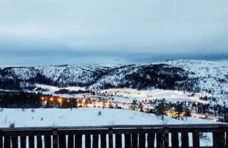
Gautefall is a mountain village in Drangedal Municipality in Telemark county, Norway. The village is located in the mountains about 12 kilometres (7.5 mi) southwest of the village of Bustrak and about 15 kilometres (9.3 mi) northeast of the village of Treungen. Gautefall is home to a ski center and tourist resort. The village area consists mostly of vacation homes and cabins. It is located in a mountainous area and is a major winter sports destination. It is a popular destination for skiing, hiking, fishing, hunting, swimming, and other recreational activities.
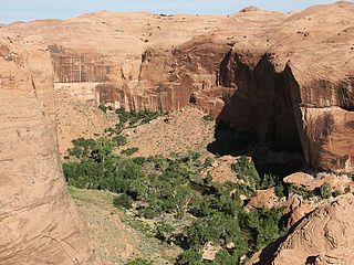
Coyote Gulch is a tributary of the Escalante River, located in Garfield and Kane Counties in southern Utah, in the western United States. Over 25 mi (40 km) long, Coyote Gulch exhibits many of the geologic features found in the Canyons of the Escalante, including high vertical canyon walls, narrow slot canyons, domes, arches, and natural bridges. The upper sections of Coyote Gulch are located within the Grand Staircase–Escalante National Monument, while its lower sections are located in the Glen Canyon National Recreation Area.

Konjic is a City and a town located in the Herzegovina-Neretva Canton of the Federation of Bosnia and Herzegovina, one of two entities that make up Bosnia and Herzegovina. It is located in northern Herzegovina, around 60 kilometres (37 mi) southwest of Sarajevo, in a mountainous, heavily wooded area, and is 268 m (879 ft) above sea level. The municipality extends on both sides of the Neretva River. According to the 2013 census, the city of Konjic has a population of 10,732 inhabitants, whereas the municipality has 25,148.

The Robson River is a short but swift, rapid and waterfall-infested river in Mount Robson Provincial Park of British Columbia. It is a tributary of the Upper Fraser River and it originates near Robson Pass, which divides the Robson River and the headwaters of the Smoky River drainage. There are three lakes along the river's course as well as four waterfalls.

Vranica is a mountain range in the Dinaric Alps of central Bosnia and Herzegovina, located between the town of Gornji Vakuf in the west and the town of Fojnica in the east, within the territory of the Federation. The highest peak is Nadkrstac at 2,110 metres (6,920 ft). Geologically, the Vranica range is part of the Dinaric Alps and formed largely of secondary and tertiary sedimentary rock, mostly limestone. Notable peaks are Nadkrstac, Locika, Rosinj and Scit. Thick shrubs of Pinus Mugo replace mixed forest—mostly beech—above 1,400 m (4,600 ft). The typical karst characteristics of the nearby Herzegovina mountains is relatively absent in Vranica, which has relatively abundant water sources. Streams that source from these mountains are the Dragača in the east, the Vrbas in the west.

Uisge Ban Falls Provincial Park is a provincial park near New Glen, in the Canadian province of Nova Scotia on Cape Breton Island. Located on the North Branch Road 14.5 kilometres (9.0 mi) north of Baddeck, the civic address of the park entrance is 715 North Branch Road, Baddeck Forks, Nova Scotia, Canada B0E 1B0.

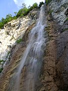
Skakavac is a waterfall formed on the Perućica, a mountain creek, in the Perućica, which is regulated as a Strict Nature Reserve as part of Sutjeska National Park in Bosnia and Herzegovina. It is one of the highest waterfalls in the country, at about 75 metres (246 ft) in height.

The Panorama Trail is a marked hiking trail in Yosemite National Park that descends along the south wall of Yosemite Valley from Glacier Point, past several major waterfalls, to Happy Isles. The trail derives its name from the panoramic vistas visible along the route, most notably Panorama Point.
Sarajevo's Ozren is complex of mountains and hilly plateaus located northeast of Sarajevo. This entire area is covered by a number of different paths and hiking trails, and it has popular picnic areas, popular for people from Sarajevo.