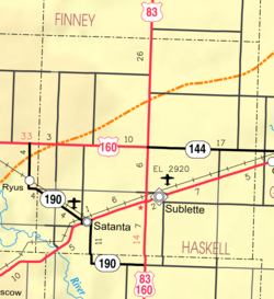
Sublette, Kansas | |
---|---|
City and county seat | |
Coordinates: 37°28′47″N100°50′42″W / 37.47972°N 100.84500°W [1] | |
Country | United States |
State | Kansas |
County | Haskell |
Founded | June 5, 1912 |
Incorporated | March 5, 1923 |
Named for | William Sublette |
Area | |
• Total | 1.05 sq mi (2.72 km2) |
• Land | 1.05 sq mi (2.72 km2) |
• Water | 0.00 sq mi (0.00 km2) |
Elevation | 2,914 ft (888 m) |
Population (2022) [3] | |
• Total | 1,333 |
• Density | 1,300/sq mi (490/km2) |
Time zone | UTC-6 (CST) |
• Summer (DST) | UTC-5 (CDT) |
ZIP code | 67877 |
Area code | 620 |
FIPS code | 20-68775 [1] |
GNIS ID | 470607 [1] |
Website | sublettekansas.com |
Sublette is a city in and the county seat of Haskell County, Kansas, United States. [1] As of 2022, the population of the city was 1,333. [3]
Sublette was founded on March 5, 1912. [4] It was named for William Lewis Sublette, a French Huguenot who was a partner in the Rocky Mountain Fur Company. Sublette was a mountain man, fur trapper and pioneer who blazed a trail through the area and was known by the local natives as "Cut Face". [5]
The first post office in Sublette was established in January 1913. [6] Around 1913, the population of Sublette was around 270. The first baby born in Sublette was named Gladys Sublette Boaz, delivered by Dr. Loring Minor.
Sublette is located at 37°28′47″N100°50′42″W / 37.47972°N 100.84500°W (37.479660, −100.845034). [7] According to the United States Census Bureau, the city has a total area of 0.92 square miles (2.38 km2), all of it land. [8]
According to the Köppen Climate Classification system, Sublette has a semi-arid climate, abbreviated "BSk" on climate maps. [9]
Climate data for Sublette, Kansas, 1991–2020 normals, extremes 1918–2019 | |||||||||||||
---|---|---|---|---|---|---|---|---|---|---|---|---|---|
Month | Jan | Feb | Mar | Apr | May | Jun | Jul | Aug | Sep | Oct | Nov | Dec | Year |
Record high °F (°C) | 80 (27) | 89 (32) | 92 (33) | 98 (37) | 105 (41) | 112 (44) | 110 (43) | 111 (44) | 105 (41) | 99 (37) | 88 (31) | 86 (30) | 112 (44) |
Mean maximum °F (°C) | 69.3 (20.7) | 74.0 (23.3) | 81.7 (27.6) | 88.9 (31.6) | 93.8 (34.3) | 100.2 (37.9) | 102.4 (39.1) | 100.5 (38.1) | 96.9 (36.1) | 89.7 (32.1) | 76.9 (24.9) | 67.6 (19.8) | 103.4 (39.7) |
Mean daily maximum °F (°C) | 49.0 (9.4) | 53.5 (11.9) | 63.3 (17.4) | 71.7 (22.1) | 80.6 (27.0) | 90.4 (32.4) | 94.4 (34.7) | 92.0 (33.3) | 85.9 (29.9) | 74.1 (23.4) | 60.1 (15.6) | 49.2 (9.6) | 72.0 (22.2) |
Daily mean °F (°C) | 34.5 (1.4) | 38.3 (3.5) | 47.4 (8.6) | 55.5 (13.1) | 65.2 (18.4) | 75.2 (24.0) | 79.5 (26.4) | 77.6 (25.3) | 70.5 (21.4) | 58.1 (14.5) | 45.0 (7.2) | 35.6 (2.0) | 56.9 (13.8) |
Mean daily minimum °F (°C) | 20.0 (−6.7) | 23.2 (−4.9) | 31.4 (−0.3) | 39.2 (4.0) | 49.8 (9.9) | 60.0 (15.6) | 64.7 (18.2) | 63.1 (17.3) | 55.1 (12.8) | 42.0 (5.6) | 29.9 (−1.2) | 22.1 (−5.5) | 41.7 (5.4) |
Mean minimum °F (°C) | 2.7 (−16.3) | 4.3 (−15.4) | 12.4 (−10.9) | 24.1 (−4.4) | 35.2 (1.8) | 47.9 (8.8) | 55.4 (13.0) | 53.9 (12.2) | 37.8 (3.2) | 25.8 (−3.4) | 12.3 (−10.9) | 1.8 (−16.8) | −4.9 (−20.5) |
Record low °F (°C) | −24 (−31) | −17 (−27) | −15 (−26) | 7 (−14) | 24 (−4) | 36 (2) | 45 (7) | 40 (4) | 25 (−4) | 8 (−13) | −3 (−19) | −18 (−28) | −24 (−31) |
Average precipitation inches (mm) | 0.44 (11) | 0.36 (9.1) | 1.09 (28) | 1.60 (41) | 2.28 (58) | 2.96 (75) | 2.72 (69) | 2.69 (68) | 1.30 (33) | 1.64 (42) | 0.58 (15) | 0.64 (16) | 18.30 (465) |
Average snowfall inches (cm) | 2.5 (6.4) | 2.5 (6.4) | 3.6 (9.1) | 0.8 (2.0) | 0.1 (0.25) | 0.0 (0.0) | 0.0 (0.0) | 0.0 (0.0) | 0.0 (0.0) | 0.7 (1.8) | 1.4 (3.6) | 3.4 (8.6) | 15.0 (38) |
Average precipitation days (≥ 0.01 in) | 1.7 | 2.1 | 3.8 | 5.3 | 5.8 | 7.2 | 6.3 | 6.8 | 3.9 | 4.2 | 2.6 | 2.5 | 52.2 |
Average snowy days (≥ 0.1 in) | 1.6 | 1.6 | 1.5 | 0.4 | 0.0 | 0.0 | 0.0 | 0.0 | 0.0 | 0.2 | 0.7 | 1.6 | 7.6 |
Source: NOAA (mean maxima/minima 1981–2010) [10] [11] |
Census | Pop. | Note | %± |
---|---|---|---|
1930 | 673 | — | |
1940 | 582 | −13.5% | |
1950 | 838 | 44.0% | |
1960 | 1,077 | 28.5% | |
1970 | 1,208 | 12.2% | |
1980 | 1,293 | 7.0% | |
1990 | 1,378 | 6.6% | |
2000 | 1,592 | 15.5% | |
2010 | 1,453 | −8.7% | |
2020 | 1,413 | −2.8% | |
U.S. Decennial Census |
As of the census [12] of 2010, there were 1,453 people, 556 households, and 409 families residing in the city. The population density was 1,579.3 inhabitants per square mile (609.8/km2). There were 626 housing units at an average density of 680.4 per square mile (262.7/km2). The racial makeup of the city was 85.1% White, 0.1% African American, 1.0% Native American, 0.1% Asian, 11.8% from other races, and 2.0% from two or more races. Hispanic or Latino of any race were 26.8% of the population.
There were 556 households, of which 38.3% had children under the age of 18 living with them, 61.0% were married couples living together, 8.1% had a female householder with no husband present, 4.5% had a male householder with no wife present, and 26.4% were non-families. 24.3% of all households were made up of individuals, and 11.4% had someone living alone who was 65 years of age or older. The average household size was 2.61 and the average family size was 3.09.
The median age in the city was 36.9 years. 28.8% of residents were under the age of 18; 7.6% were between the ages of 18 and 24; 23.5% were from 25 to 44; 27.9% were from 45 to 64; and 12.2% were 65 years of age or older. The gender makeup of the city was 49.7% male and 50.3% female.
As of the census [13] of 2000, there were 1,592 people, 574 households, and 441 families residing in the city. The population density was 1,690.2 inhabitants per square mile (652.6/km2). There were 645 housing units at an average density of 684.8 per square mile (264.4/km2). The racial makeup of the city was 84.61% White, 0.19% African American, 0.82% Native American, 0.88% Asian, 10.99% from other races, and 2.51% from two or more races. Hispanic or Latino of any race were 21.36% of the population.
There were 574 households, out of which 41.1% had children under the age of 18 living with them, 67.2% were married couples living together, 7.3% had a female householder with no husband present, and 23.0% were non-families. 20.9% of all households were made up of individuals, and 10.8% had someone living alone who was 65 years of age or older. The average household size was 2.77 and the average family size was 3.22.
In the city, the population was spread out, with 32.0% under the age of 18, 8.2% from 18 to 24, 26.5% from 25 to 44, 22.2% from 45 to 64, and 11.1% who were 65 years of age or older. The median age was 33 years. For every 100 females, there were 102.0 males. For every 100 females age 18 and over, there were 97.3 males.
The median income for a household in the city was $40,161, and the median income for a family was $43,167. Males had a median income of $33,611 versus $22,708 for females. The per capita income for the city was $17,787. About 7.8% of families and 12.1% of the population were below the poverty line, including 18.7% of those under age 18 and 9.1% of those age 65 or over.
The community is served by Sublette USD 374 public school district.
The Haskell County Monitor-Chief is the local newspaper.
There are no radio stations licensed to Sublette.
Sublette is in the Wichita–Hutchinson, Kansas television market. [14] KDGL-LD is licensed to Sublette Kansas and is the flagship station of High Plains Broadcasting, LLC. KDGL broadcasts on RF channel 23 carrying 6 video streams. Current Networks are Retro TV, Tuff TV, AMG TV, Launch TV, TheWalk TV, and PBJ TV. KDGL uses TV23 as branding for all 5 licenses including Dodge City, Garden City, Liberal, and Ulysses. Sublette was chosen for its central location in the Southwest Kansas Market and to streamline future news gathering for NewsWest23 newscasts. [15] [16]
Haskell County is a county located in the U.S. state of Kansas. Its county seat and most populous city is Sublette. As of the 2020 census, the county population was 3,780. The county was named after Dudley Haskell, a congressman during the 1870s and 1880s.
Rowley is a city in Buchanan County, Iowa, United States. The population was 270 at the time of the 2020 census.
Hardtner is a city in Barber County, Kansas, United States. As of the 2020 census, the population of the city was 167. It is located 1 mile north of the Kansas / Oklahoma state border.
Horton is a city in Brown County, Kansas, United States. As of the 2020 census, the population of the city was 1,523.
Sedan is the county seat of and the largest city in Chautauqua County, Kansas, United States. As of the 2020 census, the population of the city was 1,000.
Columbus is the second largest city and county seat of Cherokee County, Kansas, United States. As of the 2020 census, the population of the city was 2,929. It is located approximately 15 miles south-southwest of Pittsburg.
Coldwater is a city and county seat of Comanche County, Kansas, United States. As of the 2020 census, the population of the city was 687.
Enterprise is a city in Dickinson County, Kansas, United States. As of the 2020 census, the population of the city was 708.
Ulysses is a city in and the county seat of Grant County, Kansas, United States. It is named after Ulysses S. Grant, the 18th President of the United States. As of the 2020 census, the population of the city was 5,788.
North Newton is a city in Harvey County, Kansas, United States. As of the 2020 census, the population of the city was 1,814. It is located between the north side of the city of Newton and the south side of Interstate I-135. North Newton is home of Bethel College.
Satanta is a city in Haskell County, Kansas, United States. As of the 2020 census, the population of the city was 1,092. Every year there is a celebration of Satanta's Indian heritage called Satanta Day.
Lansing is a city in Leavenworth County, Kansas, United States. It is situated along the west side of the Missouri River and Kansas-Missouri state border. As of the 2020 census, the population of the city was 11,239. It is the second most populous city of Leavenworth County and is a part of the Kansas City metropolitan area. The Lansing Correctional Facility, which includes the state's main maximum-security prison, is located in Lansing.
Pleasanton is a city in Linn County, Kansas, United States. As of the 2020 census, the population of the city was 1,208.
Meade is a city in and the county seat of Meade County, Kansas, United States. As of the 2020 census, the population of the city was 1,505.
Lyndon is a city in, and the county seat of Osage County, Kansas, United States. As of the 2020 census, the population of the city was 1,037.
Quenemo is a city in Osage County, Kansas, United States, along the Marais des Cygnes River. As of the 2020 census, the population of the city was 288.
Belle Plaine is a city in Sumner County, Kansas, United States. As of the 2020 census, the population of the city was 1,467.
Wellington is a city in and the county seat of Sumner County, Kansas, United States. As of the 2020 census, the population of the city was 7,715.
Alta Vista is a city in Wabaunsee County, Kansas, United States. As of the 2020 census, the population of the city was 409.
Boulder is a census-designated place (CDP) in Sublette County, Wyoming, United States. The population was 170 at the 2010 census.
{{cite web}}
: CS1 maint: unfit URL (link)