Leonardtown is a town in and the county seat of St. Mary's County, Maryland, United States. The population was 2,930 at the 2010 census. Leonardtown is perhaps most famous for the national oyster-shucking championship that occurs annually at the St. Mary's County fairgrounds.

Lexington Park is a census-designated place (CDP) in St. Mary's County, Maryland, United States, and the principal community of the Lexington Park, Maryland Micropolitan Statistical Area. The population was 11,626 at the 2010 census.

The Severn River is a tidal estuary 14 miles (23 km) long, located in Anne Arundel County in the U.S. state of Maryland, south of the Magothy River and north of the South River.
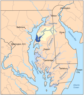
The Chester River is a major tributary of the Chesapeake Bay on the Delmarva Peninsula. It is about 43 miles (69 km) long, and its watershed encompasses 368 sq mi (950 km2), which includes 295 sq mi (760 km2) of land. Thus the total watershed area is 20% water. It forms the border between Kent County and Queen Anne's County, Maryland, with its headwaters extending into New Castle County and Kent County, Delaware. Chestertown, the seat of Maryland's Kent County, is located on its north shore. It is located south of the Sassafras River and north of Eastern Bay, and is connected with Eastern Bay through Kent Narrows.
Town Creek may refer to the following places in the United States:
Maryland's Western Shore is an area of Maryland west of the Chesapeake Bay. Originally, it included all areas not on the Eastern Shore and some colonial and later state government functions were administered separately for each region. The term no longer identifies an official region of Maryland and is used in contrast to the "Eastern Shore", also known as the "Delmarva" peninsula separated from the Maryland northeast corner of mainland with northern Delaware in the north by the Chesapeake and Delaware Canal, heavily used by transiting cargo ships along the major East Coast port cities.
The Wicomico River is a 13.0-mile-long (20.9 km) tributary of the lower tidal portion of the Potomac River located in the U.S. state of Maryland south of Washington, DC. The river empties into the Potomac at Cobb Island and St. Margaret's Island. Its watershed area is 77 square miles (200 km2), with 2% impervious surface in 1994. in Charles, St. Mary's, and southern Prince George's counties. The lower section of the river forms part of the boundary between Charles and St. Mary's counties. The Wicomico River was designated a Scenic River under the Maryland Scenic River Act in 1968, and there are Scenic River Commissions for it in both Charles and St. Mary's counties.
Mattapony was a former hundred in Worcester County, Maryland.

Leonardtown High School is a comprehensive public high school for students in grades 9-12. It offers college preparatory programs and programs that prepare students for business and technical occupations. It serves the community in the central portion of St. Mary's County, Maryland, between the Potomac River and Patuxent River. The area is a mixture of rural and suburban communities. Many of the families are employed by NAS Patuxent River, government contractors, St. Mary's College of Maryland, St Mary's County government and others involved in the traditional agriculture and water related businesses.
The South River is a 10-mile-long (16 km) tributary of the Chesapeake Bay in Anne Arundel County, Maryland in the United States. It lies south of the Severn River, east of the Patuxent River, and north of the West River and Rhode River, and drains to the Chesapeake Bay.

Town Creek is a 41.6-mile-long (66.9 km) tributary stream of the Potomac River in the U.S. states of Maryland and Pennsylvania. The creek is formed from the confluence of Sweet Root Creek and Elk Lick Creek, about 0.5 miles (0.8 km) south of Buchanan State Forest in Bedford County, Pennsylvania. Town Creek flows south along the base of Warrior Mountain into Allegany County, Maryland. The Chesapeake and Ohio Canal crosses it at the Town Creek Aqueduct. It empties into the Potomac about 4 miles (6 km) east of Oldtown, Maryland.
Popes Creek is a 3.4-mile-long (5.5 km) stream in Charles County, Maryland and a tributary of the Potomac River.
Lyons Creek is an 11.2-mile-long (18.0 km) tributary of the Patuxent River in Maryland. Lyons Creek serves as the borider between southern Anne Arundel County, Maryland and northern Calvert County, Maryland.
Hawlings River is a 12.9-mile-long (20.8 km) tributary of the Patuxent River in Montgomery County, Maryland. The watershed covers an area of about 28 square miles (73 km2). The headwaters of the river originate in the area north of Laytonsville, and the river flows southeast, entering the Patuxent about 1.5 miles (2.4 km) below the Triadelphia Reservoir. Portions of Hawlings River flow through Rachel Carson Conservation Park and Hawlings River Stream Valley Park. Tributaries of the Hawlings River include Mount Zion Tributary, Reddy Branch, Olney Mill Tributary, Gregg Tributary, and James Creek. The river and its tributaries total about 98 miles (158 km) of streams.

Mattapany-Sewall Archeological Site is an archaeological site in St. Mary's County, Maryland. It is located at the Patuxent River Naval Air Station on a level terrace approximately 45' above sea level, less than 1000' south of the Patuxent River in an unused wooded/grassy tract. Documentary evidence identifies the site as Mattapany-Sewall, a manor established in 1663 and occupied from 1666 to 1684 by Charles Calvert, 3rd Baron Baltimore. It served as a governmental meeting place and colonial arsenal, and was the scene of the 1689 battle, known as the Protestant Revolution of 1689, in which Maryland's Proprietary government was overthrown.

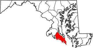
The Calvert Peninsula is part of the Western Shore region of the U.S. state of Maryland. It extends about 25 miles (40 km) into Chesapeake Bay with the main bay providing its eastern border and the Patuxent River defining its western border. It constitutes a total land area of about 350 square miles (910 km2) and is essentially conterminous with Calvert County.
Town Creek is a tributary of the Tred Avon River in Talbot County on Maryland's Eastern Shore.
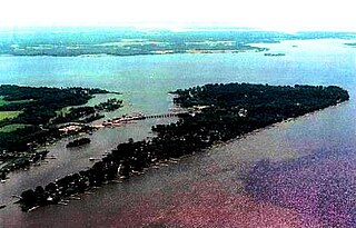
St. Mary's Peninsula is part of the Western Shore region of Maryland. From the Charles County line, just north of Charlotte Hall, Maryland, to the southern tip of St. Mary's County at Point Lookout State Park, St. Mary's Peninsula stretches about 39 miles (63 km). It is bordered on the southwest by the Potomac River, on the north and east by the Patuxent River and on the east by Chesapeake Bay. From the end of these two rivers, the peninsula has about 15 miles of shoreline along the Bay's western shore from Lexington Park, Maryland to Point Lookout. Its shoreline stretches for a total of 536 miles along the Patuxent River, Patomac River and the Chesapeake Bay.
Mill Branch of the Patuxent River in Prince George's County, Maryland is part of the Upper Patuxent Watershead.