
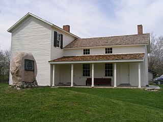
The Chief Jean Baptiste de Richardville House was built near Fort Wayne, Indiana, in 1827. Subsidized by the U.S. federal government through the 1826 Treaty of Mississinewas, it is believed to be one of only three treaty houses built east of the Mississippi River. It was designated a National Historic Landmark on March 2, 2012.

The Fort Wayne Old City Hall Building in downtown Fort Wayne, Indiana operates as a museum known as The History Center, and has served as headquarters for the Allen County–Fort Wayne Historical Society since 1980. The Richardsonian Romanesque style sandstone building was designed by the architectural firm Wing & Mahurin and built in 1893. It served as a functioning city hall for the city until 1971 when local officials moved to the City-County Building.

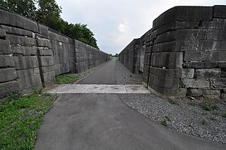
The Wabash and Erie Canal was a shipping canal that linked the Great Lakes to the Ohio River via an artificial waterway. The canal provided traders with access from the Great Lakes all the way to the Gulf of Mexico. Over 460 miles long, it was the longest canal ever built in North America.
Adams Township is one of fourteen townships in Carroll County, Indiana. As of the 2010 census, its population was 516 and it contained 209 housing units.
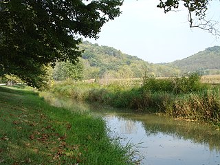
Historic Forks of the Wabash is a historic museum park near Huntington, Indiana, that features site several historic buildings, trails and remnants of the Wabash and Erie Canal. The location was the signing location of the historic Treaty at the Forks of the Wabash in 1838. The park is located along the Wabash River. It was listed on the National Register of Historic Places in 1985 as the Chief Richardville House and Miami Treaty Grounds.

The Old Vanderburgh County Courthouse, often simply called the "Old Courthouse," was once the center of Vanderburgh County, Indiana government. Construction started in the spring of 1888 and was completed in November 1890. The building was ready to be occupied by the county government in early 1891. It sits in the heart of downtown Evansville.
The Whitewater Canal, which was built between 1836 and 1847, spanned a distance of 76 miles (122 km) and stretched from Lawrenceburg, Indiana on the Ohio River to Hagerstown, Indiana near the West Fork of the White River.
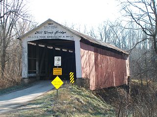
The Mill Creek Covered Bridge also known as "Thompson's Ford Covered Bridge," "Tow Path Covered Bridge," or "Earl Ray Covered Bridge" crosses Wabash Mill Creek (historic) southwest of Tangier, Indiana. It is a single span Burr Arch Truss covered bridge structure that was built by D. M. Brown in 1907.
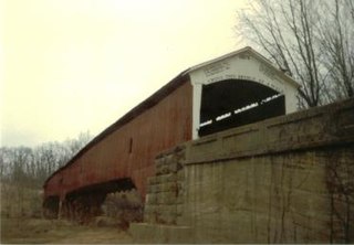
The West Union Covered Bridge formerly carried Tow Path Road over Sugar Creek north-northeast of Montezuma, Indiana. The two-span Burr Arch Truss covered bridge structure was built by Joseph J. Daniels in 1876. It is notable for being the longest standing covered bridge in Parke County, and one of the nation's best-preserved examples of the Burr truss.

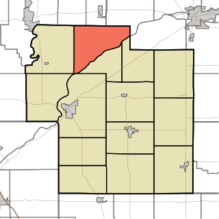
This is a list of the National Register of Historic Places listings in Carroll County, Indiana.
Erie Canal Lock 52 Complex is a national historic district located at Port Byron and Mentz in Cayuga County, New York. The district includes two contributing buildings ; three contributing engineering structures ; and archaeological sites associated with the canal operations. Lock 52 was constructed 1849-1853 as part of the Enlarged Erie Canal program. It remained in operation until the rerouting of the canal under the New York State Barge Canal System in 1917. The Erie House was built in 1894 and is a two-story frame structure that housed a saloon and hotel.

Centennial Neighborhood District is a national historic district located at Lafayette, Tippecanoe County, Indiana. The area originated as the Bartholomew and Davis Additions to Lafayette in 1829. Growth came rapidly after the Wabash and Erie Canal arrived in 1843. Growth continued with the arrival of the railroad in 1853. The Centennial Neighborhood Historic District takes its name from the Centennial School, which was constructed in 1876 on the centennial of the nation. The school was located on the north east corner of Brown Street at North 6th Street. The school has been removed and a park created at its original location.

Downtown Lafayette Historic District is a national historic district located at Lafayette, Tippecanoe County, Indiana. Lafayette began in 1825 as a transportation center for the west central area of Indiana. Its development and growth reflects the changes in transportation over the intervening years. From its location along the Wabash River, it grew first with river travel then for a short while from the Wabash and Erie Canal. When the railroads arrived in the 1850s, the town began to grow, initially along the rail lines. The Downtown Lafayette Historic District reflects these early changes.

Vermilyea Inn Historic District is a national historic district located near Fort Wayne in Aboite Township, Allen County, Indiana. The district encompasses one contributing building, the Jesse Vermilyea House, and three contributing structures. The house was built in 1839, and is a two-story, three bay, Federal style brick dwelling. It has an original two-story, four bay, gable roofed wing, a 1+1⁄2-story wood and brick garage addition built about 1945, and a 1+1⁄2-story brick addition built about 2000. The other contributing resources are the visible earthworks of the Wabash and Erie Canal and the timber platform of the canal aqueduct. Its builder, Jesse Vermilyea, opened his house as an inn and tavern and operated as such through the 19th century.

New Haven station is a historic train station located at New Haven, Allen County, Indiana. It was built in 1890 by the Wabash Railroad. It is a one-story, wood-frame building, with Stick Style / Eastlake movement ornamentation. It measures approximately 50 feet long and 20 feet wide and has a gable roof and board and batten siding.
Burris House and Potawatomi Spring was a historic home located at Adams Township, Carroll County, Indiana. The house was built between 1838 and 1840, and is a simple two-story, frame dwelling sheathed in clapboard. It sat on a limestone foundation and measured 31 feet wide and 45 feet long. It was cut into the Wabash and Erie Canal embankment and served as an inn, post office, and merchandise warehouse. The Potawatomi Spring is located nearby and was used by Native American and early settlers. The spring was a source of water for Lockport until about 1940. The house has been demolished.
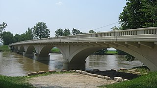
Carrollton Bridge, also known as Carroll County Bridge #132, is a historic closed-spandrel arch bridge that spans the Wabash River in Adams Township, Deer Creek Township, and Tippecanoe Township, Carroll County, Indiana. It was designed by Daniel B. Luten and built in 1927. It consists of six reinforced concrete arches. It has an overall length of 619 feet 4 inches (188.77
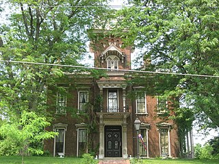
Judge Cyrus Ball House, also known as the Ball Mansion and Carriage House, is a historic home located at Lafayette, Tippecanoe County, Indiana. It was built in 1868–1869, and is a two-story, Second Empire style brick dwelling, with a three-story mansard roofed entrance tower. It sits on a limestone foundation, has intricate wood and stone detailing, and a slate roof. Also on the property is a contributing two-story, rectangular carriage house.

The Oratory of St. Patrick, also known as St. Patrick's Roman Catholic Church is a historic Roman Catholic church located at Lagro, Wabash County, Indiana. It was listed on the National Register of Historic Places in 1999.

Marion County Bridge 0501F, also known as Indiana State Bridge 534-C-3439 on SR 100, is a historic truss bridge located on the Michigan Road at Indianapolis, Marion County, Indiana. It was built in 1941–1942, as a bridge along the State Road 100 project. It consists of two identical Warren pony truss sections at each end with two Parker through truss spans at the center. The pony truss sections are each 96 feet long and the through truss spans are 174 feet long.


