
Lyon Village is a neighborhood, or "urban village" located in Arlington County, Virginia, along Lee Highway. It adjoins Arlington County's government center, and is approximately one mile west of Rosslyn and less than a mile north of Clarendon, of which it is sometimes considered a sub-neighborhood, as is Cherrydale, the mostly residential district immediately west of Lyon Village.

The Newtonville Historic District is a historic district in the village of Newtonville, in Newton, Massachusetts. The district encompasses the southern portion of the village's business district, as well as surrounding residential areas. It was listed on the National Register of Historic Places in 1986, and enlarged in 1990.

Glenville Historic District, also known as Sherwood's Bridge, is a 33.9 acres (13.7 ha) historic district in the Glenville neighborhood of the town of Greenwich, Connecticut. It is the "most comprehensive example of a New England mill village within the Town of Greenwich". It "is also historically significant as one of the town's major staging areas of immigrants, predominantly Irish in the 19th century and Polish in the 20th century" and remains "the primary settlement of Poles in the town". Further, "[t]he district is architecturally significant because it contains two elaborate examples of mill construction, designed in the Romanesque Revival and a transitional Stick-style/Queen Anne; an excellent example of a Georgian Revival school; and notable examples of domestic and commercial architecture, including a Queen Anne mansion and an Italianate store building."

The Whitney Avenue Historic District is a historic district in the East Rock neighborhood of New Haven, Connecticut. It is a 203-acre (82 ha) district which included 1,084 contributing buildings when it was listed on the National Register of Historic Places in 1989.
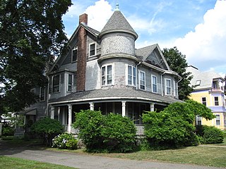
The Newton Highlands Historic District encompasses the historic heart of the village of Newton Highlands in Newton, Massachusetts. When it was added to the National Register of Historic Places in 1986, the district extended along Lincoln Street from Woodward to Hartford Streets, and included blocks of Bowdoin, Erie and Hartford Streets south of Lincoln Street. The district was enlarged in 1990 to include the cluster of commercial buildings on Lincoln Street between Hartford and Walnut Streets.
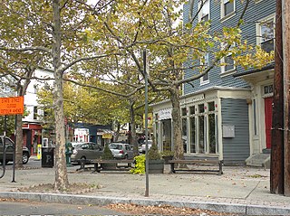
The Upper State Street Historic District encompasses a well-preserved neighborhood commercial district of the late 19th century in the East Rock neighborhood of New Haven, Connecticut. The district is an irregular strip running NNE to SSW mainly along State Street in New Haven, one block west of Interstate 91, the highway which determines the district's eastern and southern borders. The district was listed on the U.S. National Register of Historic Places in 1984.
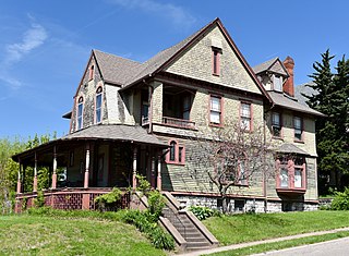
Court Hill Historic District is a historic district located in Ottumwa, Iowa, United States. It is a residential area of large homes with a few small homes in between. The district was listed on the National Register of Historic Places in 1998 as a part of Ottumwa MPS. At the time of its nomination it contained 84 resources, which included 56 contributing buildings, two contributing structures, 25 non-contributing buildings, and one non-contributing site.
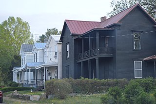
Holbrook–Ross Street Historic District is a national historic district located in Danville, Virginia. The district includes 107 contributing buildings in a primarily African-American neighborhood of Danville. It includes a full range of late 19th and early 20th century residential, commercial, and institutional structures. The majority of the houses are single-family dwellings that were built between 1880 and 1910, and includes notable examples of vernacular Italianate and Queen Anne styles. Notable buildings include the Williams House, Hargraves-Geary House, Tisden House, Leroy Johnson House, Broadnax Apartment, Calvary Baptist Church (1896), Holbrook Street Presbyterian Church, Loyal Baptist Church (1924), Wesley AME Church (1939), Westmoreland Middle School (1936), and the Annex Building (1925). Located in the district are the separately listed Hotel Danville and the Danville Municipal Building.

Mount Vernon Triangle is a neighborhood and community improvement district in the northwest quadrant of Washington, D.C. Originally a working-class neighborhood established in the 19th century, present-day Mount Vernon Triangle experienced a decline in the mid-20th century as it transitioned from residential to commercial and industrial use. The neighborhood has undergone significant and rapid redevelopment in the 21st century. It now consists mostly of high-rise condominium, apartment and office buildings. Several historic buildings in the neighborhood have been preserved and are listed on the National Register of Historic Places. Mount Vernon Triangle is now considered a good example of urban planning and a walkable neighborhood.

The Bellows Falls Neighborhood Historic District encompasses a residential area of the village Bellows Falls, Vermont. Located south of downtown Bellows Falls, the area has one of the largest concentrations of well-preserved 19th century residences in southern Vermont. It was listed on the National Register of Historic Places in 2002, and enlarged in 2007.

The George–Pine–Henry Historic District encompasses a residential area of the village Bellows Falls, Vermont. Located west of downtown Bellows Falls, the area has a significant concentration of well-preserved late 19th and early 20th-century residences. It was listed on the National Register of Historic Places in 2010.

The State Center Commercial Historic District is a nationally recognized historic district located in State Center, Iowa, United States. It was listed on the National Register of Historic Places in 2002. At the time of its nomination it contained 36 resources, which included 31 contributing buildings, two contributing structures, and three non-contributing buildings. The historic district covers the town's central business district. State Center is located at the highest point in Marshall County, midway between Marshalltown and Nevada. The town was established by the Cedar Rapids & Missouri Railroad on 80 acres (32 ha) of land in 1863. It was initially named "Centre Station," but William Barnes, the first railroad agent, changed the town's name to "State Centre."
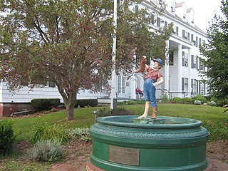
The Wallingford Main Street Historic District encompasses the historic portions of the village of Wallingford, Vermont. An essentially linear district extending along Main Street on either side of School Street, it has a well-preserved array of 19th and early-20th century residential, commercial, and civic buildings. It was listed on the National Register of Historic Places in 1984.

The Macon Historic District is a historic district in Macon, Georgia that was listed on the National Register of Historic Places in 1974 and was expanded in 1995. The original listing covered 587 acres (238 ha) and included 1,050 contributing resources; the increase added 101 acres (41 ha) and 157 contributing resources.

The Morrisville Historic District encompasses most of the historic commercial downtown area of the village of Morrisville in Morristown, Vermont. Developed in the early 19th century as a service town for the surrounding agricultural areas, it was transformed into a major service regional commercial center by the arrive of the railroad in 1872. Its surviving architecture is largely reflective of these two time periods. It was listed on the National Register of Historic Places in 1983, and enlarged in 2007.

The Cedar Rapids 2nd Avenue SE. Automobile Row Historic District is a nationally recognized historic district located in Cedar Rapids, Iowa, United States. It was listed on the National Register of Historic Places in 2015. At the time of its nomination it consisted of 24 resources, which included 17 contributing buildings, two contributing sites, four non-contributing buildings, and one non-contributing structure. This is a collection of commercial buildings that were built along the old Lincoln Highway between 1912 and 1953 to house automobile dealerships. They feature broad fronts with large display windows and open interiors. Auto repair shops were generally located at the rear of a dealership, but some were located in their own utilitarian buildings. Some of the corner lots were taken up by small gas stations. In later years, sales lots were placed adjacent to dealerships in order to display a larger number of cars. Other lots were occupied by used car lots. Prior to being converted into an automobile-centric commercial area, the district was a Victorian-era residential neighborhood. The multi-family dwelling at 309 8th St. SE remains as a reminder of that era, and it is one of the contributing properties.

The Signourney Square Historic District encompasses a neighborhood in the Asylum Hill area of Hartford, Connecticut, that was almost entirely built out in a single decade at the end of the 19th century as a middle-class residential area. It is roughly bounded by Garden, Ashley, and Woodland Streets on the east, south, and west, and by railroad tracks north of Sargeant Street to the north. The area retains much of its late 19th-century character, with relatively few modern intrusions. It was listed on the National Register of Historic Places in 1979, with small additions in 1983 and 2011.

The Pomeroy Terrace Historic District is a historic district on the east side of downtown Northampton, Massachusetts. Located south of Bridge Street east of the main railroad right-of-way, it was one of the city's most desirable residential neighborhoods of the 19th century, retaining many fine examples of residential architecture from that period. It was listed on the National Register of Historic Places in 2018.
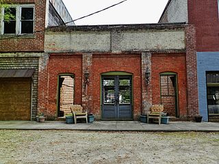
The Colbert Historic District, in Colbert, Georgia, is a 46 acres (19 ha) historic district which was listed on the National Register of Historic Places in 1984. It included 43 contributing buildings. The district is roughly bounded by 4th and 5th Streets, 4th and 8th Avenues.


