Willis' Magazine

Last updated

Willis' Magazine
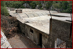
Part of Fortifications of Gibraltar
Willis' Plateau, Gibraltar
Willis Magazine DG.jpg
The outside
Princess Anne's Battery diagram.png
Map of a portion of Willis's Plateau, including Princess Royal's Battery, Princess Anne's Battery, Princess Amelia's Battery and Willis' Magazine
Coordinates 36°08′42″N5°20′49″W / 36.145054°N 5.346867°W / 36.145054; -5.346867 Coordinates: 36°08′42″N5°20′49″W / 36.145054°N 5.346867°W / 36.145054; -5.346867
Type Magazine
Site information
Owner Government of Gibraltar

Willis' Magazine is an 18th-century large magazine in the British Overseas Territory of Gibraltar. The magazine sits on a plateau with several artillery batteries.

Description

cross section of the magazine Willis Magazine diag.gif
cross section of the magazine

This magazine is said to be the "largest of its type" remaining anywhere in the world. It has been in a derelict state for decades although work has taken place to clear debris. The general layout consisting of four large magazine chambers surrounded by a two level lighting corridor. This would have provided light through windows along the walls whilst preventing any naked flame from oil lamps from getting near to the magazine's gunpowder. [1]

The magazine sits on Willis's Plateau which is a historic place for the placement of Gibraltar's northern defences. The batteries include Princess Anne's Battery, Princess Amelia's Battery and Princess Royal's Battery and behinds these are the start of the World War II Tunnels of Gibraltar. [1]

The magazine is named for Captain Willis who made such a contribution in the Twelfth Siege of Gibraltar in 1704-5 that this magazine was named for him. He also gave his name to Willis' Road, Willis' Battery (now Princess Royal's Battery), Willis' Cave and Guard. [2]

Related Research Articles

<span class="mw-page-title-main">Europa Point</span>

Europa Point, is the southernmost point of Gibraltar. At the end of the Rock of Gibraltar, the area is flat and occupied by such features as a playing field and a few buildings. On a clear day, views of North Africa can be seen across the Strait of Gibraltar including Ceuta and the Rif Mountains of Morocco; as well as the Bay of Gibraltar and the Spanish towns along its shores. It is reached from the old town by Europa Road.

<span class="mw-page-title-main">Capital punishment in Gibraltar</span>

Capital punishment in Gibraltar included public execution in the nineteenth century until 1864. The last sentence of death was passed in 1952. Under British law, capital punishment was almost abolished in 1965, in line with British practice. It was entirely abolished in 2002 along with all other British Overseas Territories.

<span class="mw-page-title-main">Parson's Lodge Battery</span> Gun battery on the Rock of Gibraltar

Parson's Lodge Battery is a coastal battery and fort in the British Overseas Territory of Gibraltar.

<span class="mw-page-title-main">Streets in Gibraltar</span>

Streets in the British Overseas Territory of Gibraltar are represented by road signs as in the United Kingdom. As of 2007, Gibraltar has a network of 29 kilometres (18 mi) of roads.

<span class="mw-page-title-main">Princess Caroline's Battery</span>

Princess Caroline's Battery is an artillery battery in the British Overseas Territory of Gibraltar. It is located at the northern end of the Upper Rock Nature Reserve, at the junction of Willis's Road and Queen's Road. The nearby Princess Anne's Battery is often mistakenly referred to as Princess Caroline's Battery. The latter was built in 1732 and named after Princess Caroline, the daughter of King George II. Princess Caroline's Battery was updated in 1905, and a 6 inch Mark VII gun was mounted above the magazine. Later, the battery was decommissioned and the gun removed. The underground magazine is now home to the Military Heritage Centre, which includes the Memorial Chamber.

<span class="mw-page-title-main">Princess Anne's Battery</span>

Princess Anne's Battery is an artillery battery in the British Overseas Territory of Gibraltar. It is located on Willis's Plateau at the northern end of the Upper Rock Nature Reserve, above Princess Caroline's Battery. It was named after Anne, Princess Royal and Princess of Orange, the eldest daughter of George II. However, its name is often confused with those of other batteries in the area. In 1732, guns were first mounted on the battery, which also saw action during the Great Siege of Gibraltar. Princess Anne's Battery was updated in the nineteenth and twentieth centuries, with the latter modernisation entailing the installation of four QF 5.25 inch guns with both anti-aircraft and coastal defence capabilities. The battery was manned into the early 1980s, after which it was decommissioned. The guns were refurbished in the early twenty-first century, and represent the world's only intact battery of 5.25 inch anti-aircraft guns. Princess Anne's Battery is listed with the Gibraltar Heritage Trust.

<span class="mw-page-title-main">O'Hara's Battery</span>

O'Hara's Battery is an artillery battery in the British Overseas Territory of Gibraltar. It is located at the highest point of the Rock of Gibraltar, near the southern end of the Upper Rock Nature Reserve, in close proximity to Lord Airey's Battery. It was constructed in 1890 at the former site of a watchtower that had earned the name O'Hara's Folly. The battery and tower were both named after the Governor of Gibraltar Charles O'Hara. The first gun mounted on the battery was a 6-inch breech loading gun, which was replaced with a 9.2 inch Mark X BL gun in 1901. The battery was in use during World War II and was last fired during training exercises in 1976. O'Hara's Battery has been refurbished and is open to the public. The battery and its associated works are listed with the Gibraltar Heritage Trust.

<span class="mw-page-title-main">Princess Amelia's Battery</span>

Princess Amelia's Battery is an artillery battery in the British Overseas Territory of Gibraltar. It is located on Willis's Plateau at the northern end of the Upper Rock Nature Reserve, adjacent to Gun No. 4 of Princess Anne's Battery. It was named after Princess Amelia of Great Britain, the second daughter of George II. It was formerly referred to as the 2nd Willis's Battery. The plateau and its batteries had previously been named after an artillery officer by the name of Willis who was outstanding during the capture of Gibraltar in 1704. Princess Amelia's Battery saw action during the Great Siege of Gibraltar, during which it sustained substantial damage. Little remains of the original site, aside from two derelict buildings. The battery is listed with the Gibraltar Heritage Trust.

<span class="mw-page-title-main">Princess Royal's Battery</span>

Princess Royal's Battery is an artillery battery in the British Overseas Territory of Gibraltar. It is located on Willis's Plateau at the northern end of the Upper Rock Nature Reserve, just southeast of Princess Anne's Battery. Formerly known as Willis' Battery, and later, Queen Anne's Battery or Queen's Battery, it was renamed in the late 18th century after Charlotte, Princess Royal, the eldest daughter of George III. The battery was active from the early 18th century until at least the mid-20th century. However, it has been decommissioned and guns are no longer present. Princess Royal's Battery is listed with the Gibraltar Heritage Trust.

<span class="mw-page-title-main">Hanover Battery</span> Former artillery battery in Gibraltar

Hanover Battery was an artillery battery on the north west part of the British Overseas Territory of Gibraltar. The battery is casemated. Beneath the battery was a tunnel known as Hanover Gallery.

Willis' Battery is a former artillery battery on the north side of the British Overseas Territory of Gibraltar. It overlooks the isthmus between Spain and Gibraltar.

<span class="mw-page-title-main">Fortifications of Gibraltar</span> Defensive military constructions at the Rock of Gibraltar

The Gibraltar peninsula, located at the far southern end of Iberia, has great strategic importance as a result of its position by the Strait of Gibraltar where the Mediterranean Sea meets the Atlantic Ocean. It has repeatedly been contested between European and North African powers and has endured fourteen sieges since it was first settled in the 11th century. The peninsula's occupants – Moors, Spanish, and British – have built successive layers of fortifications and defences including walls, bastions, casemates, gun batteries, magazines, tunnels and galleries. At their peak in 1865, the fortifications housed around 681 guns mounted in 110 batteries and positions, guarding all land and sea approaches to Gibraltar. The fortifications continued to be in military use until as late as the 1970s and by the time tunnelling ceased in the late 1960s, over 34 miles (55 km) of galleries had been dug in an area of only 2.6 square miles (6.7 km2).

<span class="mw-page-title-main">Great North Road, Gibraltar</span>

The Great North Road is a large road tunnel in the British Overseas Territory of Gibraltar. It was constructed by the British military during World War II inside the Rock of Gibraltar and remains property of the Ministry of Defence to this day. The road allowed lorries to travel from the north to the south of Gibraltar entirely within the Rock. The tunnel still contains the remains of World War II buildings such as Nissen huts, kitchens, offices as well as a generating station and period anti-submarine nets.

<span class="mw-page-title-main">King's Lines</span>

The King's Lines are a walled rock-cut trench on the lower slopes of the north-west face of the Rock of Gibraltar. Forming part of the Northern Defences of the fortifications of Gibraltar, they were originally created some time during the periods when Gibraltar was under the control of the Moors or Spanish. They are depicted in a 1627 map by Don Luis Bravo de Acuña, which shows their parapet following a tenaille trace. The lines seem to have been altered subsequently, as maps from the start of the 18th century show a more erratic course leading from the Landport, Gibraltar's main land entrance, to the Round Tower, a fortification at their western end. A 1704 map by Johannes Kip calls the Lines the "Communication Line of the Round Tower".

Princess Charlotte's Battery was an artillery battery built in Gibraltar during the 18th century. It was constructed in the Willis's Plateau area on the upper northern slopes of the Rock of Gibraltar. Formerly called Catalan Battery, it was renamed after Sophia Charlotte of Hanover, the wife of King Frederick I of Prussia, who was the brother of King George I of Great Britain. The battery saw service in the Thirteenth Siege of Gibraltar in 1727 and inflicted substantial damage on the attacking Spanish forces. By 1773 it had two 12-pdr guns. Its armament was upgraded to four 24-pdrs in 1834, and from 1885 to 1889 it mounted two 64-pdr rifled muzzle loaders.

<span class="mw-page-title-main">Tunnels of Gibraltar</span>

The tunnels of Gibraltar were constructed over the course of nearly 200 years, principally by the British Army. Within a land area of only 2.6 square miles (6.7 km2), Gibraltar has around 34 miles (55 km) of tunnels, nearly twice the length of its entire road network. The first tunnels, excavated in the late 18th century, served as communication passages between artillery positions and housed guns within embrasures cut into the North Face of the Rock. More tunnels were constructed in the 19th century to allow easier access to remote areas of Gibraltar and accommodate stores and reservoirs to deliver the water supply of Gibraltar.

<span class="mw-page-title-main">Prince's Lines</span>

The Prince's Lines are part of the fortifications of Gibraltar, situated on the lower slopes of the north-west face of the Rock of Gibraltar. They are located at a height of about 70 feet (21 m) on a natural ledge above the Queen's Lines, overlooking the landward entrance to Gibraltar, and run from a natural fault called the Orillon to a cliff at the southern end of the isthmus linking Gibraltar with Spain. The lines face out across the modern Laguna Estate, which stands on the site of the Inundation, an artificial lake created to obstruct landward access to Gibraltar. They were constructed to enfilade attackers approaching Gibraltar's Landport Front from the landward direction.

<span class="mw-page-title-main">Windmill Hill (Gibraltar)</span> A pair of plateaux

Windmill Hill or Windmill Hill Flats is one of a pair of plateaux, known collectively as the Southern Plateaux, at the southern end of the British Overseas Territory of Gibraltar. It is located just to the south of the Rock of Gibraltar, which descends steeply to the plateau. Windmill Hill slopes down gently to the south with a height varying from 120 metres (390 ft) at the north end to 90 metres (300 ft) at the south end. It covers an area of about 19 hectares, though about 6 hectares at the north end is built over. The plateau is ringed to the south and east with a line of cliffs which descend to the second of the Southern Plateaux, Europa Flats, which is itself ringed by sea cliffs. Both plateaux are the product of marine erosion during the Quaternary period and subsequent tectonic uplift. Windmill Hill was originally on the shoreline and its cliffs were cut by the action of waves, before the ground was uplifted and the shoreline moved further out to the edge of what is now Europa Flats.

References

This article contains text from Discover-Gibraltar.com.
  1. 1 2 Crone, Jim. "18th Century Magazine (see tunnels in Index)" . Retrieved 18 June 2013.
  2. Jackson, William G. F. (1986). The Rock of the Gibraltarians. Cranbury, NJ: Associated University Presses. p. 108. ISBN   0-8386-3237-8.