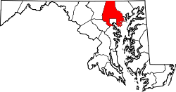
Woodlawn, Maryland | |
---|---|
Coordinates: 39°18′13″N76°44′15″W / 39.30361°N 76.73750°W | |
Country | United States |
State | Maryland |
County | Baltimore |
Established | 1904 [1] |
Area | |
• Total | 9.57 sq mi (24.79 km2) |
• Land | 9.54 sq mi (24.71 km2) |
• Water | 0.03 sq mi (0.08 km2) |
Population (2020) | |
• Total | 39,986 |
• Density | 4,191.84/sq mi (1,618.52/km2) |
Time zone | UTC−5 (Eastern (EST)) |
• Summer (DST) | UTC−4 (EDT) |
ZIP codes | 21043, 21235, 21207, 21241, 21228, 21244, 21229 |
FIPS code | 24-86475 |
Woodlawn is an unincorporated community and census-designated place in Baltimore County, Maryland. Per the 2020 census, the population was 39,986. [3] It is home to the headquarters of the Social Security Administration (SSA) and the Centers for Medicare and Medicaid Services (CMS). It is bordered by Catonsville on the south, by the Patapsco River and Howard County on the west, by Randallstown and Lochearn to the north, and by the City of Baltimore to the east. Parts of Woodlawn are sometimes informally referred to as Security, Maryland, due to the importance of the SSA's headquarters as well as nearby Security Boulevard (Maryland Route 122) and Security Square Mall.
The Lorraine Park Cemetery Gate Lodge and St. Mary's Episcopal Church were listed on the National Register of Historic Places in 1985. [4]
Woodlawn is located at 39°18′13″N76°44′15″W / 39.30361°N 76.73750°W (39.303695, −76.737425). [5]
According to the United States Census Bureau, the CDP has a total area of 9.6 square miles (24.9 km2), all land.
Census | Pop. | Note | %± |
---|---|---|---|
1960 | 19,254 | — | |
1970 | 28,811 | 49.6% | |
1980 | 29,453 | 2.2% | |
1990 | 32,907 | 11.7% | |
2000 | 36,079 | 9.6% | |
2010 | 37,879 | 5.0% | |
2020 | 39,986 | 5.6% | |
U.S. Decennial Census [6] 2010 [7] 2020 [8] Census area returned as Woodlawn-Rockdale-Milford Mills in 1960. Census area returned as Woodlawn-Woodmoor in 1970 Census area returned as Security in 1980 |
Race / Ethnicity (NH = Non-Hispanic) | Pop 2000 [9] | Pop 2010 [7] | Pop 2020 [8] | % 2000 | % 2010 | % 2020 |
---|---|---|---|---|---|---|
White alone (NH) | 13,532 | 8,109 | 6,235 | 37.51% | 21.41% | 15.59% |
Black or African American alone (NH) | 18,465 | 23,048 | 22,339 | 51.18% | 60.85% | 55.87% |
Native American or Alaska Native alone (NH) | 100 | 87 | 80 | 0.28% | 0.23% | 0.20% |
Asian alone (NH) | 2,237 | 3,378 | 6,190 | 6.20% | 8.92% | 15.48% |
Pacific Islander alone (NH) | 18 | 8 | 8 | 0.05% | 0.02% | 0.02% |
Other race alone (NH) | 104 | 105 | 292 | 0.29% | 0.28% | 0.73% |
Mixed race or Multiracial (NH) | 774 | 952 | 1,383 | 2.15% | 2.51% | 3.46% |
Hispanic or Latino (any race) | 849 | 2,192 | 3,459 | 2.35% | 5.79% | 8.65% |
Total | 36,079 | 37,879 | 39,986 | 100.00% | 100.00% | 100.00% |
As of the census [10] of 2010, there were 37,879 people and 14,618 households. The population density was 3,971.4 people per square mile. There were 15,417 housing units at an average density of about 1,713.5 per square mile. [11] The racial makeup of the community was 38.39% White, 51.50% African American, 0.30% Native American, 6.22% Asian, 0.05% Pacific Islander, 1.06% from other races, and 2.48% from two or more races. Hispanic or Latino of any race were 2.35% of the population.
There were 13,936 households, out of which 33.8% had children under the age of 18 living with them, 43.6% were married couples living together, 18.3% had a female householder with no husband present, and 33.4% were non-families. 27.2% of all households were made up of individuals, and 7.3% had someone living alone who was 65 years of age or older. The average household size was 2.57 and the average family size was 3.13.
The community's age distribution is: 26.7% under the age of 18, 7.6% from 18 to 24, 33.1% from 25 to 44, 22.0% from 45 to 64, and 10.5% who were 65 years of age or older. The median age was 35 years. For every 100 women, there were 88.6 men. For every 100 women age 18 and over, there were 84.0 men.
The median income for a household in the community was $48,878, and the median income for a family was $54,490. Men had a median income of $36,789 versus $31,242 for women. The per capita income for the community was $21,710. About 4.3% of families and 6.3% of the population were below the poverty line, including 7.4% of those under age 18 and 6.8% of those age 65 or over.
Some major roads in the Woodlawn area are:
The Woodlawn area is a transportation hub for the Maryland Transit Administration and is served by several bus routes. These include:
The Security Boulevard corridor is part of the route of the proposed Red Line.
The Woodlawn Volunteer Fire Company was founded in 1941 as a civil defense unit. At the conclusion of World War II, the fire company incorporated and began to provide fire suppression and ambulance service to the community. The fire house is currently located on Woodlawn Drive near Windsor Mill. It is one of 33 volunteer fire companies in Baltimore County. The County Fire Department comprises 26 "career" (paid) fire companies and 33 volunteer companies. [12]
Brooklyn Park is a census-designated place (CDP) in Anne Arundel County, Maryland, United States. The population was 14,373 at the 2010 census, and 16,112 at the 2020 census.
Ferndale is a census-designated place (CDP) in Anne Arundel County, Maryland, United States. At the 2010 census, the population was 16,746.
Linthicum is a census-designated place (CDP) and unincorporated community in Anne Arundel County, Maryland, United States. The population was 10,324 at the 2010 census. It is located directly north of Baltimore–Washington International Thurgood Marshall Airport (BWI).
Arbutus is an unincorporated community and a census-designated place in Baltimore County, Maryland, United States. The population was 20,483 at the 2010 census. The census area also contains the communities of Halethorpe and Relay, in which all three names were used during the 1960 census when the area had a population of 22,402.
Catonsville is a census-designated place (CDP) in Baltimore County, Maryland. The population was 44,701 at the 2020 US Census. The community is a streetcar suburb of Baltimore along the city's western border. The town is known for its proximity to the Patapsco River and Patapsco Valley State Park, making it a regional mountain biking hub. The town is also notable as a local hotbed of music, earning it the official nickname of "Music City, Maryland." Catonsville contains the majority of the University of Maryland, Baltimore County (UMBC), a major public research university with close to 14,000 students.
Cockeysville is a census-designated place (CDP) in Baltimore County, Maryland, United States. The population was 20,776 at the 2010 census.
Essex is an unincorporated community and census-designated place in Baltimore County, Maryland, United States. Essex history dates back to 1909. The population was 40,505 in the 2020 census, up from 39,262 in the 2010 census.
Lochearn is an unincorporated community and census-designated place in Baltimore County, Maryland, United States, located immediately to the west of the City of Baltimore. Per the 2020 census, the population was 25,511.
Milford Mill is an unincorporated community and census-designated place in Baltimore County, Maryland, United States. Per the 2020 census, the population was 30,622.
Owings Mills is an unincorporated community and census-designated place in Baltimore County, Maryland, United States. It is a suburb of Baltimore. Per the 2020 census, the population was 35,674. Owings Mills is home to the northern terminus of the Baltimore Metro Subway, and housed the Owings Mills Mall until its closure in 2015. It is also home to the Baltimore Ravens' headquarters facility, and the studios for Maryland Public Television. In 2008, CNNMoney.com named Owings Mills number 49 of the "100 Best Places to Live and Launch".
Parkville is an unincorporated community and census-designated place in Baltimore County, Maryland, United States. As of the 2010 census, the population was 30,734.
Randallstown is an unincorporated community and census-designated place in Baltimore County, Maryland, United States. It is named after Christopher and Thomas Randall, two 18th-century tavern-keepers. At that time, Randallstown was a tollgate crossroads on the Liberty Turnpike, a major east–west thoroughfare. It is a suburb of Baltimore, with a population of 33,655 as of the 2020 census. As of 2020 it was 72 percent African American. In the 1990s, Randallstown transitioned to a majority African American community.
Rosedale is an unincorporated community and census-designated place in Baltimore County, Maryland, United States. The population was 19,257 at the 2010 United States Census.
White Marsh is an unincorporated community and census-designated place in Baltimore County, Maryland, United States. The population was 9,513 at the 2010 census. White Marsh is a northeast suburb of Baltimore.
Eldersburg is an unincorporated community and census-designated place (CDP) in Carroll County, Maryland, United States. The population was 30,531 at the 2010 census.
Fallston is a census-designated place (CDP) in Harford County, Maryland, United States. The population was 8,958 at the 2010 census, up from 8,427 in 2000. Fallston is a semi-rural community consisting mostly of farms and suburban-like developments.
Brandywine is the name of an unincorporated area in Prince George's County, Maryland, United States, that refers both to a census-designated place (CDP) and a zip code area which is much larger (20613), whose areas overlap. The population of Brandywine at the 2020 U.S. Census was 10,550 for the CDP, and the population of ZIP code 20613 was 11,860 in 2010.
Woodlawn is an unincorporated area and census-designated place (CDP) in Prince George's County, Maryland, United States. As of the 2020 census it had a population of 7,541.
Jessup is an unincorporated community and census-designated place in Howard and Anne Arundel counties, about 15 miles (24 km) southwest of Baltimore, Maryland, United States. Per the 2020 census, the population was 10,535.
Baltimore Highlands is a census-designated place (CDP) in Baltimore County, Maryland, United States, directly south of the city of Baltimore. The population was 7,019 at the 2010 census. At the 2000 census and earlier, the area was delineated as part of the Lansdowne-Baltimore Highlands CDP.