Yengarie, Queensland

Last updated

Yengarie
Queensland
Yengarie Sugar Refinery ruins (2002).jpg
Yengarie Sugar Refinery ruins, 2002
Australia Queensland location map.svg
Red pog.svg
Yengarie
Coordinates 25°32′34″S152°35′45″E / 25.5427°S 152.5958°E / -25.5427; 152.5958 (Yengarie (centre of locality))
Population615 (2021 census) [1]
 • Density22.61/km2 (58.56/sq mi)
Postcode(s) 4650
Area27.2 km2 (10.5 sq mi)
Time zone AEST (UTC+10:00)
Location
LGA(s) Fraser Coast Region
State electorate(s) Maryborough
Federal division(s) Wide Bay
Suburbs around Yengarie:
Dunmora Oakhurst Tinana
Dunmora Yengarie Tinana
Yerra Grahams Creek Tinana

Yengarie is a rural locality in the Fraser Coast Region, Queensland, Australia. [2] In the 2021 census, Yengarie had a population of 615 people. [1]

Contents

Geography

The North Coast railway line enters the locality from the south (Grahams Creek) and exits to the north (Oakhurst). The locality is served by Yengarie railway station ( 25°33′20″S152°36′38″E / 25.5556°S 152.6106°E / -25.5556; 152.6106 (Yengarie railway station) ). [3]

History

Yengarie School opened on 30 March 1868 as a non-vested school (funded by the Queensland Government but not operated by the government). [4] [5] On 14 July 1873, it became Yenagarie State School (operated by the government). In 1873, it had 89 students and a new school building was being constructed to replace the old building described as "dilapidated and overcrowded". [6] It closed in 1963. [7] [8] It was at 340 Old Mill Road ( 25°33′19″S152°37′00″E / 25.55534°S 152.61673°E / -25.55534; 152.61673 (Yengarie State School (former)) ). [9] [10]

Yengarie Hall was opened in 1886. It was designed by architect James Robertson. It was used for meetings of the Antigua Divisional Board until 1903 and then the Antigua Shire Council until 1917 . [11]

Demographics

In the 2016 census, Yengarie had a population of 460 people. [12]

In the 2021 census, Yengarie had a population of 615 people. [1]

Heritage listings

Yengarie has a number of heritage-listed sites, including:

Education

There are no schools in Yengarie. The nearest government primary schools are Mungar State School in Mungar to the south and Sunbury State School in Maryborough to the north-east. The nearest government secondary school is Aldridge State High School in Maryborough. [15]

Amenities

Yengarie Hall is a community centre on Mungar Road ( 25°33′08″S152°36′17″E / 25.5521°S 152.6048°E / -25.5521; 152.6048 (YENGARIE HALL) ). [16] Its grounds contain facilities for tennis and basketball as well as a playground and BBQ/picnic facilities. [17] [18]

Pleasant View Park is at the end of Pleasant View Road and on the bank of the Mary River ( 25°32′57″S152°37′36″E / 25.5491°S 152.6267°E / -25.5491; 152.6267 (Pleasant View Park) ). [19] Pleasant View Road boat ramp is within the park providing access to the river ( 25°32′58″S152°37′40″E / 25.5494°S 152.6278°E / -25.5494; 152.6278 (Pleasant View Road boat ramp) ). It is managed by the Fraser Coast Regional Council. [20]

See also

Related Research Articles

<span class="mw-page-title-main">Tiaro, Queensland</span> Town in Queensland, Australia

Tiaro is a rural town and locality in the Fraser Coast Region, Queensland, Australia. In the 2021 census, the locality of Tiaro had a population of 778 people.

<span class="mw-page-title-main">River Heads, Queensland</span> Town in Queensland, Australia

River Heads is a coastal town and locality in the Fraser Coast Region, Queensland, Australia. In the 2021 census, the locality of River Heads had a population of 2,044 people.

<span class="mw-page-title-main">Brooweena, Queensland</span> Town in Queensland, Australia

Brooweena is a rural town and locality in the Fraser Coast Region, Queensland, Australia. In the 2021 census, the locality of Brooweena had a population of 91 people.

<span class="mw-page-title-main">Theebine</span> Town in Queensland, Australia

Theebine is a rural town and locality split between the Gympie Region and the Fraser Coast Region, both in Queensland, Australia.

<span class="mw-page-title-main">Duckinwilla, Queensland</span> Suburb of Fraser Coast Region, Queensland, Australia

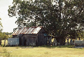
Duckinwilla is a rural locality in the Fraser Coast Region, Queensland, Australia. In the 2021 census, Duckinwilla had a population of 38 people.

<span class="mw-page-title-main">Tinana, Queensland</span> Town in Queensland, Australia

Tinana is a rural town and locality in the Fraser Coast Region, Queensland, Australia. In the 2021 census, the locality of Tinana had a population of 5,872 people.

<span class="mw-page-title-main">Torbanlea</span> Town in Queensland, Australia

Torbanlea is a rural town and locality in the Fraser Coast Region, Queensland, Australia. In the 2021 census, the locality of Torbanlea had a population of 841 people.

<span class="mw-page-title-main">Antigua, Queensland</span> Suburb of Fraser Coast Region, Queensland, Australia

Antigua is a rural locality in the Fraser Coast Region, Queensland, Australia. In the 2021 census, Antigua had a population of 126 people.

<span class="mw-page-title-main">Mungar</span> Suburb of Fraser Coast Region, Queensland, Australia

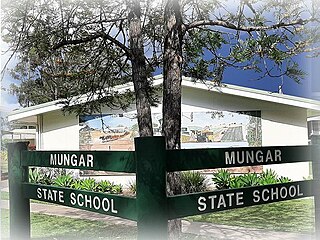
Mungar is a rural locality in the Fraser Coast Region, Queensland, Australia. In the 2021 census, Mungar had a population of 328 people.

<span class="mw-page-title-main">Bauple, Queensland</span> Town in Queensland, Australia

Bauple is a rural town and locality in the Fraser Coast Region, Queensland, Australia. In the 2021 census, the locality of Bauple had a population of 745 people.

St Helens is a rural locality in the Fraser Coast Region, Queensland, Australia. In the 2021 census, St Helens had a population of 123 people.

<span class="mw-page-title-main">Magnolia, Queensland</span> Suburb of Fraser Coast Region, Queensland, Australia

Magnolia is a rural locality in the Fraser Coast Region, Queensland, Australia. In the 2021 census, Magnolia had a population of 115 people.

Pioneers Rest is a rural locality in the Fraser Coast Region, Queensland, Australia. In the 2021 census, Pioneers Rest had a population of 78 people.

Yerra is a rural locality in the Fraser Coast Region, Queensland, Australia. In the 2021 census, Yerra had a population of 110 people.

<span class="mw-page-title-main">Oakhurst, Queensland</span> Suburb of Fraser Coast Region, Queensland, Australia

Oakhurst is a mixed-use locality in the Fraser Coast Region, Queensland, Australia. In the 2021 census, Oakhurst had a population of 1,717 people.

Tuan is a coastal rural town and locality in the Fraser Coast Region, Queensland, Australia. In the 2021 census, the locality of Tuan had a population of 140 people.

Doongul is a rural locality in the Fraser Coast Region, Queensland, Australia. In the 2021 census, Doongul had a population of 35 people.

Dunmora is a rural locality in the Fraser Coast Region, Queensland, Australia. In the 2021 census, Dunmora had a population of 281 people.

<span class="mw-page-title-main">Grahams Creek, Queensland</span> Suburb of Fraser Coast Region, Queensland, Australia

Grahams Creek is a rural locality in the Fraser Coast Region, Queensland, Australia. In the 2021 census, Grahams Creek had a population of 149 people.

Pilerwa is a rural locality in the Fraser Coast Region, Queensland, Australia. In the 2021 census, Pilerwa had a population of 50 people.

References

  1. 1 2 3 Australian Bureau of Statistics (28 June 2022). "Yengarie (SAL)". 2021 Census QuickStats. Retrieved 28 February 2023. OOjs UI icon edit-ltr-progressive.svg
  2. "Yengarie – locality in Fraser Coast Region (entry 47268)". Queensland Place Names. Queensland Government . Retrieved 10 June 2019.
  3. "Railway stations and sidings - Queensland". Queensland Open Data. Queensland Government. 2 October 2020. Archived from the original on 5 October 2020. Retrieved 5 October 2020.
  4. "No title". Maryborough Chronicle, Wide Bay and Burnett Advertiser . Vol. VIII, no. 539. Queensland, Australia. 25 December 1867. p. 2. Retrieved 27 July 2024 via National Library of Australia.
  5. "No title". Maryborough Chronicle, Wide Bay and Burnett Advertiser . Vol. VIII, no. 555. Queensland, Australia. 19 February 1868. p. 2. Archived from the original on 27 July 2024. Retrieved 27 July 2024 via National Library of Australia.
  6. "No title". Maryborough Chronicle, Wide Bay and Burnett Advertiser . No. 1412. Queensland, Australia. 23 August 1873. p. 2. Archived from the original on 27 July 2024. Retrieved 27 July 2024 via National Library of Australia.
  7. "Agency ID 6232, Yengarie State School". Queensland State Archives . Retrieved 27 July 2024.
  8. Queensland Family History Society (2010), Queensland schools past and present (Version 1.01 ed.), Queensland Family History Society, ISBN   978-1-921171-26-0
  9. "Queensland Two Mile series sheet 2m112" (Map). Queensland Government. 1941. Archived from the original on 27 July 2024. Retrieved 27 July 2024.
  10. "Layers: Locality; Road and rail; Land parcel". Queensland Globe. Queensland Government. Archived from the original on 19 December 2017. Retrieved 27 July 2024.
  11. Seymour, George (20 January 2020). "History: Halls stand as reminders of councils gone by". Fraser Coast Chronicle . Retrieved 17 November 2024.
  12. Australian Bureau of Statistics (27 June 2017). "Yengarie (SSC)". 2016 Census QuickStats. Retrieved 20 October 2018. OOjs UI icon edit-ltr-progressive.svg
  13. "Central Sugar Mill Ruins (entry 602488)". Queensland Heritage Register . Queensland Heritage Council. Retrieved 7 July 2013.
  14. "Yengarie Sugar Refinery ruins (entry 600970)". Queensland Heritage Register . Queensland Heritage Council. Retrieved 7 July 2013.
  15. "Layers: Locality; Schools and school catchments". Queensland Globe. Queensland Government. Archived from the original on 19 December 2017. Retrieved 17 November 2024.
  16. "Building points - Queensland". Queensland Open Data. Queensland Government. 17 November 2020. Archived from the original on 25 November 2020. Retrieved 25 November 2020.
  17. "Yengarie Hall Grounds". Fraser Coast Regional Council. Retrieved 17 November 2024.
  18. "Yengarie Hall ground facilities get a facelift". Fraser Coast Regional Council. Retrieved 17 November 2024.
  19. "Land for public recreation - Queensland". Queensland Open Data. Queensland Government. 20 November 2020. Archived from the original on 22 November 2020. Retrieved 22 November 2020.
  20. "Recreational Boating Facilities Queensland". Queensland Open Data. Queensland Government. 12 November 2020. Archived from the original on 22 November 2020. Retrieved 22 November 2020.

Further reading