Tajimi is a city located in Gifu, Japan. As of 1 March 2020, the city had an estimated population of 110,070 in 46,580 households, and a population density of 1200 people per km2. The total area of the city was 117.01 square kilometres (45.18 sq mi). The city is famous for its production of Mino ware ceramics, especially in the Oribe and Seto styles. Tajimi is a member of the World Health Organization’s Alliance for Healthy Cities (AFHC).
Minokamo is a city located in Gifu, Japan. As of 1 January 2019, the city had an estimated population of 56,972 and a population density of 74.81 persons per km2, in 22,508 households. The total area of the city was 74.81 square kilometres (28.88 sq mi).
Kakamigahara is a city located in southern Gifu Prefecture in Japan. As of 1 January 2019, the city had an estimated population of 148,225, and a population density of 1700 persons per km2, in 59,736 households. The total area of the city was 87.81 km2 (33.90 sq mi).

Kani is a city located in Gifu, Japan. As of 1 April 2024, the city had an estimated population of 99,826 and a population density of 1100 persons per km2, in 42,286 households. The total area of the city was 87.57 square kilometres (33.81 sq mi).

Ichinomiya is a city located in Aichi Prefecture, Japan. The city is sometimes called Owarichinomiya to avoid confusion with other municipalities of the same name, including Ichinomiya and Ichinomiya in Chiba Prefecture. As of 1 October 2019, the city had an estimated population of 379,654 in 161,434 households, and a population density of 3,336 persons per km2. The total area of the city was 113.82 square kilometres (43.95 sq mi).

Kasugai is a city in Aichi Prefecture, Japan. As of 1 October 2019, the city had an estimated population of 306,764, and a population density of 3,306 persons per km2. The total area of the city is 92.78 square kilometres (35.82 sq mi). The city is sometimes called Owarikasugai to avoid confusion with other municipality of the same name, including Kasugai in Yamanashi Prefecture.

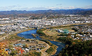
Inuyama is a city in Aichi Prefecture, Japan. As of 1 October 2019, the city had an estimated population of 73,420 in 31,276 households, and a population density of 980 persons per km2. The total area of the city is 74.90 square kilometres (28.92 sq mi). The name of the city literally translates to "Dog Mountain". The name appears in historical records from 1336 AD, but its origin is unknown.
Kōnan is a city located in Aichi Prefecture, Japan. As of 1 October 2019, the city had an estimated population of 97,903 in 41,363 households, and a population density of 3,242 inhabitants per square kilometre (8,400/sq mi). The total area of the city is 30.20 km2 (11.66 sq mi).

Tōkai is a city located in Aichi Prefecture, Japan. As of 1 October 2019, the city had an estimated population of 113,698 in 51,035 households, and a population density of 2,618 persons per km2. The total area of the city was 43.43 square kilometres (16.77 sq mi).

Chita is a city in Aichi Prefecture, Japan. As of 1 October 2019, the city had an estimated population of 83,891 in 35,798 households, and a population density of 1,828 persons per km2. The total area of the city is 45.90 km2 (17.72 sq mi).
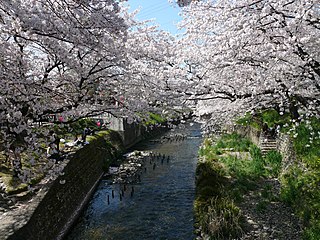
Iwakura is a city located in Aichi Prefecture, Japan. As of 1 October 2019, the city had an estimated population of 47,929 in 21,805 households, and a population density of 4,578 persons per km². The total area of the city was 10.47 square kilometres (4.04 sq mi). It is the city with the smallest area in the prefecture, and is the 10th smallest city in Japan. Iwakura city is famous for its "Cherry Blossom Festival" which mostly takes place around the end of March every year. Iwakura's cherry blossom is located at the symbol of the city "Gojo river" and lists as one of the top 100 best cherry blossom spots in Japan. The town is also known for its power lines.

Aichi Prefecture is a prefecture of Japan located in the Chūbu region of Honshū. Aichi Prefecture has a population of 7,552,873 and a geographic area of 5,172.92 square kilometres (1,997.28 sq mi) with a population density of 1,460 inhabitants per square kilometre (3,800/sq mi). Aichi Prefecture borders Mie Prefecture to the west, Gifu Prefecture and Nagano Prefecture to the north, and Shizuoka Prefecture to the east. Nagoya is the capital and largest city of the prefecture.

Fusō is a town located in Niwa District, Aichi Prefecture, Japan. As of 1 October 2019, the town had an estimated population of 34,144 in 14,017 households, and a population density of 3,051 persons per km2. The total area of the town was 11.19 square kilometres (4.32 sq mi).

Kōta is a town located in Nukata District, Aichi Prefecture, in the Tōkai region of Japan. As of 1 October 2019, the town had an estimated population of 42,200 in 16,198 households, and a population density of 744 persons per km2. The total area of the town was 56.72 square kilometres (21.90 sq mi).

Miyoshi is a city located in central Aichi Prefecture, Japan. As of 1 October 2019, the city had an estimated population of 62,782 in 24,260 households, and a population density of 1,950 persons per km2. The total area of the city was 32.19 square kilometres (12.43 sq mi).

Sakahogi is a town located in Kamo District, Gifu Prefecture, Japan. As of 1 January 2018, the town had an estimated population of 8,253 and a population density of 640 persons per km2, in 3359 households. The total area of the town was 12.87 square kilometres (4.97 sq mi).

Komaki is a city located in Aichi Prefecture, Japan. As of 1 October 2019, the city had an estimated population of 148,872 in 68,174 households, and a population density of 2,370 inhabitants per square kilometre (6,100/sq mi). The total area of the city was 62.81 square kilometres (24.25 sq mi). Komaki is commonly associated with the former Komaki Airport, which is located on the border between Komaki and neighboring Kasugai.

Kitanagoya is a city in Aichi Prefecture, Japan. As of 1 October 2019, the city had an estimated population of 86,068 in 36,904 households, and a population density of 4,685 inhabitants per square kilometre (12,130/sq mi). The total area of the city is 18.37 square kilometres (7.09 sq mi). Kitanagoya is a member of the World Health Organization’s Alliance for Healthy Cities (AFHC).
National Route 41 is a national highway connecting Nagoya, Aichi Prefecture, and Toyama, Toyama Prefecture, Japan. The bulk of the road runs through Gifu Prefecture. The route is also referred to as Yon-ichi and Shippin, based on the Japanese readings for the route numbering.

Okuma Corporation is a machine tool builder based in Ōguchi, Aichi Prefecture, Japan. It has global market share in CNC machine tools such as CNC lathes, machining centers, and turn-mill machining centers. The company also offers FA products and servomotors.