Kani is a city located in Gifu, Japan. As of 1 April 2024, the city had an estimated population of 99,826 and a population density of 1100 persons per km2, in 42,286 households. The total area of the city was 87.57 square kilometres (33.81 sq mi).
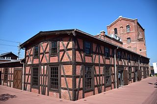
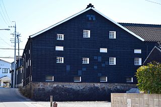
Handa is a city located in Aichi Prefecture, Japan. As of 1 October 2019, the city had an estimated population of 118,259 in 51,846 households, and a population density of 2,494 persons per km2. The total area of the city was 47.42 square kilometres (18.31 sq mi).
Hekinan is a city in Aichi Prefecture, Japan. As of 1 October 2019, the city had an estimated population of 72,864 in 29,139 households, and a population density of 1,986 persons per km2. The total area of the city was 36.68 square kilometres (14.16 sq mi).

Kariya is a city in central Aichi Prefecture, Japan. As of 1 October 2019, the city had an estimated population of 153,162 in 66,751 households, and a population density of 3,040 persons per km2. The total area of the city is 50.39 square kilometres (19.46 sq mi).

Toyota, formerly known as Koromo, is a city in Aichi Prefecture, Japan. As of 1 October 2019, the city had an estimated population of 426,162 and a population density of 464 people per km2. The total area was 918.32 square kilometres (354.57 sq mi). It is located about 50 minutes from Nagoya by way of the Meitetsu Toyota Line.

Anjō is a city in Aichi Prefecture, Japan. As of 1 October 2019, the city had an estimated population of 188,693 in 76,087 households, and a population density of 2,193 persons per km². The total area of the city was 86.05 square kilometres (33.22 sq mi).
Nishio is a city located in Aichi Prefecture, in the Chūbu region of Japan. As of 1 October 2019, the city had an estimated population of 169,984 in 65,553 households, with a population density of 1,054 persons per km2. The total area of the city was 160.22 square kilometres (61.86 sq mi). It is a regional commercial and manufacturing center and the country's leading producer of powdered green tea.

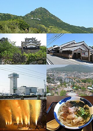
Gamagōri is a city in Aichi Prefecture, Japan. As of 1 October 2019, the city had an estimated population of 80,063 in 32,800 households, and a population density of 1,407 persons per km2. The total area of the city is 56.92 square kilometres (21.98 sq mi).

Tokoname is a city in Aichi Prefecture, Japan. As of 1 October 2019, the city had an estimated population of 57,872 in 24,872 households, and a population density of 1,035 persons per km2. The total area of the city is 55.90 square kilometres (21.58 sq mi).

Ōbu is a city located in Aichi Prefecture, Japan. As of 1 October 2019, the city had an estimated population of 92,179 in 39,382 households, and a population density of 2,739 persons per km2. The total area of the city is 33.66 square kilometres (13.00 sq mi). Ōbu has been a member of the World Health Organization’s Alliance for Healthy Cities (AFHC) since June 5, 2000.

Chita is a city in Aichi Prefecture, Japan. As of 1 October 2019, the city had an estimated population of 83,891 in 35,798 households, and a population density of 1,828 persons per km2. The total area of the city is 45.90 km2 (17.72 sq mi).

Chiryū is a city in central Aichi Prefecture, Japan. It belongs to the Nishimikawa region. As of 1 October 2019, the city had an estimated population of 71,992 in 32,579 households, and a population density of 4,414 persons per km². The total area of the city is 16.31 square kilometres (6.30 sq mi).

Takahama is a city located in central Aichi Prefecture, Japan. As of 1 October 2019, the city had an estimated population of 48,736 in 20,500 households, and a population density of 3,717 persons per km2. The total area of the city is 13.11 square kilometres (5.06 sq mi).
Yatomi is a city located in Aichi Prefecture, Japan. As of December 1, 2019, the city had an estimated population of 44,589 in 18,185 households and a population density of 910 persons per km2. The total area of the city is 49.0 square kilometres (18.9 sq mi). The between of the border, and neighboring town of Kanie.

Agui is a town located in Chita District, Aichi Prefecture, Japan. As of 1 October 2019, the town had an estimated population of 28,291 in 10,682 households, and a population density of 1,189 persons per km². The total area of the town was 23.80 square kilometres (9.19 sq mi).

Higashiura is a town located in Chita District, Aichi Prefecture, Japan. On 31 April 2023, the town had an estimated population of 50,182 in 21,426 households, and a population density of 1,611 per square kilometre (4,170/sq mi). This makes the town the most populous town in Aichi Prefecture, surpassing Takahama, Iwakura in population. The town is also the second most populous town in Japan, being surpassed by Fuchū, Hiroshima. The total area was 31.14 square kilometres (12.02 sq mi).
Minamichita is a town in Chita District, Aichi Prefecture, Japan. As of 1 October 2019, the town had an estimated population of 17,393 in 7338 households, and a population density of 453 persons per km2. The total area of the town was 38.37 square kilometres (14.81 sq mi).

Mihama is a town located in Chita District, Aichi Prefecture, Japan. As of 1 October 2019, the town had an estimated population of 22,701 in 8852 households, and a population density of 491 persons per km². The total area of the town was 46.20 square kilometres (17.84 sq mi)
Toyohashi is a city in Aichi Prefecture, Japan. As of 1 December 2019, the city had an estimated population of 377,453 in 160,516 households and a population density of 1,400 persons per km2. The total area of the city was 261.86 square kilometres (101.10 sq mi). By area, Toyohashi was Aichi Prefecture's second-largest city until March 31, 2005, when it was surpassed by the city of Toyota, which had merged with six peripheral municipalities.
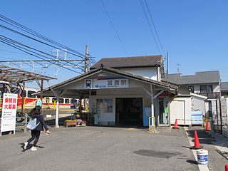
Fuki Station is a junction railway station in the town of Taketoyo, Chita District, Aichi Prefecture, Japan, operated by Meitetsu.