Komaki

Last updated • 4 min readFrom Wikipedia, The Free Encyclopedia
Komaki
小牧市
Downtown Komaki01.jpg
Mount Komaki from Mount Miroku.jpg
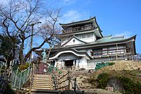
Upper:Komaki Castle
Lower:Komaki Skyline
Flag of Komaki, Aichi.svg
Logo of Komaki City.svg
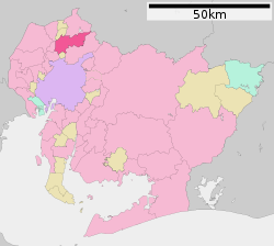
Komaki in Aichi Prefecture Ja.svg
Location of Komaki in Aichi Prefecture
Japan location map with side map of the Ryukyu Islands.svg
Red pog.svg
Komaki
 
Coordinates: 35°17′27.6″N136°54′43.6″E / 35.291000°N 136.912111°E / 35.291000; 136.912111
Country Japan
Region Chūbu (Tōkai)
Prefecture Aichi
Government
  - MayorSuzuo Yamashita
Area
  Total62.81 km2 (24.25 sq mi)
Population
 (1 October 2019)
  Total148,872
  Density2,400/km2 (6,100/sq mi)
Time zone UTC+9 (Japan Standard Time)
- TreeTabunoki ( Machilus thunbergii )
- Flower Azalea
Phone number0568-72-2101
Address1-1 Horinouchi, Komaki-shi, Aichi-ken 485-8650
Website Official website

Komaki (小牧市, Komaki-shi) is a city located in Aichi Prefecture, Japan. As of 1 October 2019, the city had an estimated population of 148,872 in 68,174 households, [1] and a population density of 2,370 inhabitants per square kilometre (6,100/sq mi). The total area of the city was 62.81 square kilometres (24.25  sq mi ). Komaki is commonly associated with the former Komaki Airport, which is located on the border between Komaki and neighboring Kasugai.

Contents

Geography

Downtown of Komaki City Komaki City Central Library exterior 2021-03-27 ac (1).jpg
Downtown of Komaki City

Komaki is located in the middle of the Nōbi Plain, west-central Aichi Prefecture, north of the Nagoya metropolis. The city skyline is dominated by Mount Komaki, which is topped with Komaki Castle.

Climate

The city has a climate characterized by hot and humid summers, and relatively mild winters (Köppen climate classification Cfa). The average annual temperature in Komaki is 15.7 °C (60.3 °F). The average annual rainfall is 1,769 mm (69.6 in) with September as the wettest month. The temperatures are highest on average in August, at around 28.1 °C (82.6 °F), and lowest in January, at around 4.2 °C (39.6 °F). [2]

Demographics

Per Japanese census data, [3] the population of Komaki has increased rapidly over the past 60 years.

Historical population
YearPop.±%
1960 43,470    
1970 79,606+83.1%
1980 103,233+29.7%
1990 124,441+20.5%
2000 143,122+15.0%
2010 147,059+2.8%

Surrounding municipalities

Flag of Aichi Prefecture.svg Aichi Prefecture

History

Komakiyama Castle Komakishirekishikan.jpg
Komakiyama Castle
Oda Nobunaga Odanobunaga.jpg
Oda Nobunaga

Ancient history

Archaeological remains from the Japanese Paleolithic through Yayoi period have been found in what is now Komaki, and burial tumuli from the Kofun period are also common.

Feudal period

During the Sengoku period, Oda Nobunaga used Komaki Castle as his headquarters from which he launched his invasion of Mino Province and later the area surrounding Mount Komaki was the site of the Battle of Komaki and Nagakute in 1584.

Early modern period

It was part of the holdings of Owari Domain during the Edo period, and prospered as a post town on the route connecting Nagoya with the Nakasendō highway.

Late modern period

During the Meiji period establishment of the modern municipalities system, the area was organized into villages under Higashikasugai District, Aichi. Komaki was proclaimed a town on July 16, 1906, through the merger of four villages.

Contemporary history

Komaki was raised to city status on January 1, 1955, after merging with the village of Kitasato in Nishikasugai District, Aichi.

Government

Komaki City hall KomakiCityHall02.jpg
Komaki City hall

Komaki has a mayor-council form of government with a directly elected mayor and a unicameral city legislature of 25 members. The city contributes two members to the Aichi Prefectural Assembly. In terms of national politics, the city is part of Aichi 16th district of the lower house of the Diet of Japan.

Sister cities

International

Sister cities
Friendship city

National

Friendship city

Economy

Komaki CBD Downtown Komaki seen from Komakiyama Castle.jpg
Komaki CBD
Toukadai New Town Tokadai Chuo Park09.jpg
Toukadai New Town

Komaki has a mixed economy, with agriculture (rice and horticulture), commence, and light manufacturing industries playing important roles.

Komaki's GDP per capita (Nominal) was ¥5,859,100 in 2014. [6] [7]

Primary sector of the economy

Agriculture

Poultry farming

Secondary sector of the economy

Manufacturing

Sumitomo Riko (Previously known as Tokai Gomme), a global rubber and synthetic resin products manufacturing company, whose automotive anti-vibration components hold the largest global market share, has its headquarters in the city. [8]

Tertiary sector of the economy

Commerce

Due to its highway connections with the Nagoya metropolis, it is also becoming a bedroom community.

Companies headquartered in Komaki

Education

Universities

Schools

Elementary and secondary education

Komaki has 16 public elementary schools and nine public junior high schools operated by the city government, and three public high schools operated by the Aichi Prefectural Board of Education. There is also one private high school. The prefecture also operates one special education school for the handicapped.

International School

Transportation

Around Komaki Station Komaki City Central Library terrace202107-2.jpg
Around Komaki Station

Airways

Airports

Railways

Conventional lines

Meitetsu logomark 2.svg Meitetsu

The Peachliner, formally the Tōkadai Shin-kōtsū Peach Liner (桃花台新交通ピーチライナー) was a people mover which operated from 1991 until September 30, 2006, when it became the first people-mover system in Japan to cease operations. [10]

Roads

Expressways

Japan National Route

Local attractions

Komaki Central Public Hall Komaki CCI & Komaki Central Public Hall 2.JPG
Komaki Central Public Hall
Historic sites
Parks

Culture

Festivals

Sports

SexNamecompetitionLeagueHomeSponsorSince
Men Nagoya Diamond Dolphins Basketball B.League (B1) Dolphins Arena
Park Arena Komaki
Nagoya Diamond Dolphins
(Mitsubishi Electric)
1950
Men Nagoya Oceans Futsal F.League Takeda Teva Ocean Arena
Park Arena Komaki
Teva Takeda Pharma2006

Noted people from Komaki

Related Research Articles

<span class="mw-page-title-main">Nagoya</span> Designated city in Chūbu, Japan

Nagoya is the largest city in the Chūbu region of Japan. It is the fourth-most populous city in Japan, with a population of 2.3 million in 2020, and the principal city of the Chūkyō metropolitan area, which is the third-most populous metropolitan area in Japan with a population of 10.11 million. Located on the Pacific coast in central Honshu, it is the capital and most populous city of Aichi Prefecture, with the Port of Nagoya being Japan's largest seaport.

<span class="mw-page-title-main">Nagoya Airfield</span> Domestic airport in Japan

Nagoya Airfield, also known as Komaki Airport or Nagoya Airport, is an airport which lies within the local government areas of Toyoyama, Komaki, Kasugai and Nagoya in Aichi Prefecture, Japan. Prior to 2005, it was once an international airport, but is now a domestic secondary airport serving Nagoya while the current primary civil airport for Nagoya is Chūbu Centrair International Airport in Tokoname.

<span class="mw-page-title-main">Ichinomiya, Aichi</span> Core city in Chūbu, Japan

Ichinomiya is a city located in Aichi Prefecture, Japan. The city is sometimes called Owarichinomiya to avoid confusion with other municipalities of the same name, including Ichinomiya and Ichinomiya in Chiba Prefecture. As of 1 October 2019, the city had an estimated population of 379,654 in 161,434 households, and a population density of 3,336 persons per km2. The total area of the city was 113.82 square kilometres (43.95 sq mi).

<span class="mw-page-title-main">Kasugai, Aichi</span> Special city in Chūbu, Japan

Kasugai is a city in Aichi Prefecture, Japan. As of 1 October 2019, the city had an estimated population of 306,764, and a population density of 3,306 persons per km2. The total area of the city is 92.78 square kilometres (35.82 sq mi). The city is sometimes called Owarikasugai to avoid confusion with other municipality of the same name, including Kasugai in Yamanashi Prefecture.

<span class="mw-page-title-main">Inuyama, Aichi</span> City in Chūbu, Japan

Inuyama is a city in Aichi Prefecture, Japan. As of 1 October 2019, the city had an estimated population of 73,420 in 31,276 households, and a population density of 980 persons per km2. The total area of the city is 74.90 square kilometres (28.92 sq mi). The name of the city literally translates to "Dog Mountain". The name appears in historical records from 1336 AD, but its origin is unknown.
<span class="mw-page-title-main">Kōnan, Aichi</span> City in Chūbu, Japan

Kōnan is a city located in Aichi Prefecture, Japan. As of 1 October 2019, the city had an estimated population of 97,903 in 41,363 households, and a population density of 3,242 inhabitants per square kilometre (8,400/sq mi). The total area of the city is 30.20 km2 (11.66 sq mi).

<span class="mw-page-title-main">Inazawa</span> City in Chūbu, Japan

Inazawa is a city located in Aichi Prefecture, Japan. As of 1 October 2019, the city had an estimated population of 135,580 in 54,999 households, and a population density of 1,709 inhabitants per square kilometre (4,430/sq mi). The total area of the city was 79.35 km2 (30.64 sq mi).

<span class="mw-page-title-main">Aichi Prefecture</span> Prefecture of Japan

Aichi Prefecture is a prefecture of Japan located in the Chūbu region of Honshū. Aichi Prefecture has a population of 7,552,873 and a geographic area of 5,172.92 square kilometres (1,997.28 sq mi) with a population density of 1,460 inhabitants per square kilometre (3,800/sq mi). Aichi Prefecture borders Mie Prefecture to the west, Gifu Prefecture and Nagano Prefecture to the north, and Shizuoka Prefecture to the east. Nagoya is the capital and largest city of the prefecture.

<span class="mw-page-title-main">Toyoyama</span> Town in Nishikasugai District, Aichi Prefecture, Japan

Toyoyama is a town located in Nishikasugai District, Aichi Prefecture, Japan. As of 1 October 2019, the town had an estimated population of 15,630 in 6,757 households, and a population density of 2,529 persons per km2. The total area of the town is 6.18 square kilometres (2.39 sq mi).

<span class="mw-page-title-main">Kita-ku, Nagoya</span> Ward in Japan

Kita Ward is one of the 16 wards of the city of Nagoya in Aichi Prefecture, Japan. As of 1 October 2019, the ward had an estimated population of 163,555 and a population density of 9,330 persons per km2. The total area was 17.53 km2.

<span class="mw-page-title-main">Moriyama-ku, Nagoya</span> Ward in Japan

Moriyama is one of the wards of the city of Nagoya in Aichi Prefecture, Japan. As of 1 October 2019, the ward has an estimated population of 176,298 and a population density of 5,184 inhabitants per square kilometre (13,430/sq mi). The total area is 34.01 km2 (13.13 sq mi).

<span class="mw-page-title-main">Hōnensai</span> Japanese festival

Harvest Festival is a fertility festival celebrated every year on March 15 in some locations in Aichi Prefecture, Japan. Hōnen means prosperous year in Japanese, implying a rich harvest, while a matsuri is a festival. The Hōnen festival and ceremony celebrate the blessings of a bountiful harvest and all manner of prosperity and fertility.

<span class="mw-page-title-main">Chūkyō metropolitan area</span> Metropolitan Area based in Nagoya, Japan

Chūkyō, or the Chūkyō region, is a major metropolitan area in Japan that is centered on the city of Nagoya in Aichi Prefecture. The area makes up the most urbanized part of the Tōkai region. The population of 10,110,000 over an area of 7,072 square kilometers. Nevertheless, like most of Japan's major metro areas, the core of it lies on a fertile alluvial plain, in this case, the Nōbi Plain.

<span class="mw-page-title-main">Tōnō</span>

Tōnō (東濃) is the southeastern portion of Gifu Prefecture in the Chūbu region of Japan. The Tōnō region received its name as a combination of the kanji for "east" (東) and "Mino" (美濃). The borders of this region are not officially set, but it generally consists of the following cities: Tajimi, Toki, Mizunami, Ena and Nakatsugawa. Occasionally, Kani, usually part of the Chūnō region, is also included as being part of Tōnō.

<span class="mw-page-title-main">Komaki Station</span> Railway station in Komaki, Aichi Prefecture, Japan

Komaki Station is a railway station in the city of Komaki, Aichi Prefecture, Japan, operated by Meitetsu.

<span class="mw-page-title-main">Komakihara Station</span> Railway station in Komaki, Aichi Prefecture, Japan

Komakihara Station is a railway station in the city of Komaki, Aichi Prefecture, Japan, operated by Meitetsu.

<span class="mw-page-title-main">Tagata Jinja-mae Station</span> Railway station in Komaki, Aichi Prefecture, Japan

Tagata Jinja-mae Station is a railway station in the city of Komaki, Aichi Prefecture, Japan, operated by Meitetsu.

<span class="mw-page-title-main">Aotsuka Kofun</span> Kofun period burial mound in Inuyama, Japan

The Aotsuka Kofun (青塚古墳) is a Kofun period burial mound, located in the Aotsuka neighborhood of the city of Inuyama, Aichi in the Tōkai region of Japan. It was designated a National Historic Site of Japan in 1983. It is the second largest kofun found in Aichi Prefecture after the Danpusan Kofun in Nagoya.

<span class="mw-page-title-main">Tagata Shrine</span> Shinto shrine

Tagata Shrine (田縣神社) is a small shrine located in Komaki City, Aichi Prefecture, Japan, near Nagoya Airfield.

References

  1. "Komaki City official statistics" (in Japanese). Archived from the original on 2019-10-23. Retrieved 2019-10-23.
  2. "Komaki climate data".
  3. Komaki population statistics
  4. "International Exchange". List of Affiliation Partners within Prefectures. Council of Local Authorities for International Relations (CLAIR). Archived from the original on 24 December 2015. Retrieved 21 November 2015.
  5. "Komaki:Interaction with Yakumo". Archived from the original on 2017-03-20. Retrieved 2021-09-09.
  6. 市民所得 [Citizen Income](PDF). Archived from the original (PDF) on 22 August 2018.
  7. "Komaki Population (December 2014)". 1 December 2014.
  8. "Business Locations". Sumitomo Riko . Archived from the original on 12 November 2020. Retrieved 11 November 2020.
  9. "Escolas Brasileiras Homologadas no Japão" (Archive). Embassy of Brazil in Tokyo. February 7, 2008. Retrieved on October 13, 2015.
  10. Peachliner home page Archived 2018-12-15 at the Wayback Machine (in Japanese)