
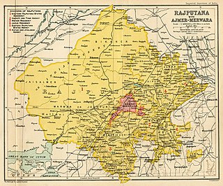
The Rajputana Agency was a political office of the British Indian Empire dealing with a collection of native states in Rajputana, under the political charge of an Agent reporting directly to the Governor-General of India and residing at Mount Abu in the Aravalli Range. The total area of the states falling within the Rajputana Agency was 127,541 square miles (330,330 km2), with eighteen states and two estates or chiefships.
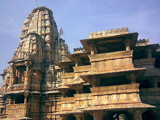
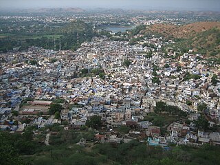
Banswara is a city in the Banswara district in southern Rajasthan, India. The name, Banswara, came from king ‘Bansiya Bhil’.
Vagad is a region in southeastern Rajasthan state of western India. Its boundaries are roughly defined by those of the districts of Dungarpur and Banswara. Major cities of the region are Dungarpur and Banswara.
Dungarpur is a city in the southernmost part of Rajasthan, India.

Banswara District has an area of 5,037 km2 (1,945 sq mi), which is 1.47% of Rajasthan state, India. The city of Banswara is the district headquarters. It is bounded on the north by Udaipur District, on the northeast by Pratapgarh District, on the east and southeast by Madhya Pradesh state, on the southwest by Gujarat state, and on the west by Dungarpur District.

Dungarpur District is a district of the state of Rajasthan in western India. The town of Dungarpur is the district headquarters.
Mewar Residency was a political subdivision of Rajputana Agency in British India. After treaty relations between Mewar and the East India Company commenced in 1818, the British government created a political sub-division known as Mewar Agency with its headquarters in Nimuch. In 1860–61, the headquarters were moved to Udaipur and, in 1881–82, the designation was changed from 'Agency' to 'Residency.' As of 1908, the Mewar Residency consisted of the four states of Udaipur, Banswara, Dungarpur, and Partabgarh, with headquarters in Udaipur.

Alirajpur State was formerly a princely state of India, administratively under the Bhopawar Agency subdivision of the Central India Agency. The state covered an area of 2165 square kilometres, with a population of 50,185 in 1901 and its capital at Alirajpur. The average revenue of the state was Rs.100,000 in 1901.

Dungarpur State was a princely state during the British Raj. Its capital was the city of Dungarpur in the southernmost area of present-day Rajasthan State in India. In 1901 the total population of Dungarpur State was 100,103, while that of the town was 6,094.

Pratapgarh State, also known as 'Partabgarh', was one of the princely states of India during the period of the British Raj. The state was founded in 1425 as Kanthal state and was later renamed after its capital located in Pratapgarh, Rajasthan.
Simalwara is a census town in Dungarpur district in the Indian state of Rajasthan. It is the administrative headquarters for Simalwara Tehsil.

Maharana Amar Singh I, the Maharana ruler of Mewar Kingdom, was the eldest son and successor of Maharana Pratap I. He was the 14th Rana of Mewar, ruling from January 19, 1597 till his death on January 26, 1620.

Maharana Raj Singh I, was the Maharana of Mewar Kingdom and eldest son of Maharana Jagat Singh I. He fought against Mughal Empire and annexed many Mughal territories He participated in Rajput-Mughal War (1679–1707) and defeated the Mughals.

The State of Shahpura or Princely State of Shahpura was a princely state in Shahpura, Bhilwara during the era of British India. Its relations with the British were managed by the Rajputana Agency. The last ruler of Shahpura signed the accession to join the Indian Union in 1949.
The Kingdom of Santrampur or later Sant State was a kingdom and later a princely state in subsidiary alliance with British India. It was ruled by Mahipavat branch of the Paramara dynasty.

Sonepur, also known as Sonpur State, was one of the princely states of India during the period of the British Raj. Its ruler was entitled to a nine-gun salute. Formerly it was placed under the Central India Agency, but in 1905 it was transferred to the Eastern States Agency. Its capital was Sonepur, the only significant town in the area. The former state's territory is in the present-day Subarnapur district, Odisha.

Jhabua State was one of the princely states of India during the period of the British Raj. It had its capital in Jhabua town. Most of the territory of the princely state was inhabited by the Bhil people, who constituted a majority of the population. The revenue of the state in 1901 was Rs.1,10,000.

Govindgiri, also known as Govind Guru Banjara, (1858–1931) was a social and religious reformer in the early 1900s in the tribal border areas of present-day Rajasthan and Gujarat states in India. He is seen as having popularized the Bhagat movement, which was first started in the 18th century.
Banswara is one of the 200 Legislative Assembly constituencies of Rajasthan state in India.
The Mangarh massacre occurred on 17 November 1913, when British and Indian troops attacked the stronghold of Govindgiri Banjara at the end of the Bhil Revolt. It occurred on a hillock in the Mangarh Hills of Rajasthan. There are no accurate figures for the number of Bhil, Banjara who were killed, but estimates range from "several Bhils died" to the oral tradition that 1,500 Banjara tribals were killed.


