
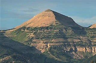
Sharkstooth Peak is a 12,468-foot-elevation (3,800-meter) mountain summit in Montezuma County, Colorado.

Bannock Peak is a 10,329-foot (3,148-metre) mountain summit in the southern section of the Gallatin Range in Yellowstone National Park, in the U.S. state of Wyoming. The peak ranks as the sixth-highest peak in the Gallatin Range. Precipitation runoff from the mountain drains west into headwaters of the Gallatin River and east into Panther Creek which is a tributary of the Gardner River. Topographic relief is significant as the summit rises nearly 2,000 feet above Panther Creek in one mile (1.6 km). This mountain's toponym was officially adopted in 1897 by the United States Board on Geographic Names.

White Rock is a cliff with an 11,284-foot-elevation (3,439-meter) summit located in Sublette County of Wyoming, United States.

Mount Lester is a 12,342-foot-elevation (3,762-meter) mountain summit located in Sublette County, Wyoming, United States.

Ramshorn Peak is an 11,635-foot-elevation (3,546-meter) mountain summit located in Fremont County of Wyoming, United States.

Old Baldy is a 9,156-foot (2,791-metre) double summit mountain located in Teton County of the U.S. state of Montana.

Mount Geikie is a 12,378-foot-elevation (3,773-meter) mountain summit in Sublette County, Wyoming, United States.

Ladd Peak is a 12,967-foot-elevation (3,952-meter) mountain summit in Sublette County, Wyoming, United States.

Darwin Peak is an 11,647-foot-elevation (3,550-meter) mountain summit in Teton County, Wyoming, United States.
Hodges Peak is an 11,180-foot-elevation (3,408-meter) mountain summit in Sublette County, Wyoming, United States.

Two Ocean Mountain is a 10,724-foot-elevation (3,269-meter) summit in Teton County, Wyoming, United States.

Virginia Peak is a 10,141-foot-elevation (3,091-meter) mountain summit in Lincoln County, Wyoming, United States.

Man Peak is a 10,326-foot-elevation (3,147-meter) mountain summit in Lincoln County, Wyoming, United States.
Loaf Mountain is a 11,722-foot-elevation (3,573-meter) summit in Johnson County, Wyoming, United States.
Ross Peak is a 9,008-foot-elevation (2,746-meter) mountain summit in Gallatin County, Montana, United States.

Hardscrabble Peak is a 9,571-foot-elevation (2,917-meter) mountain summit in Gallatin County, Montana, United States.
Pomp Peak is a 9,576-foot-elevation (2,919-meter) mountain summit in Gallatin County, Montana, United States.

Saddle Peak is a 9,159-foot-elevation (2,792-meter) mountain summit in Gallatin County, Montana, United States.

Indian Peak is a 10,929-foot-elevation (3,331-meter) mountain summit in Park County, Wyoming, United States.

Hurricane Mesa is an 11,069-foot-elevation (3,374-meter) mountain summit in Park County, Wyoming, United States.


