Related Research Articles
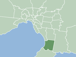
The City of Frankston is a local government area (LGA) in Victoria, Australia in the southern suburbs of Melbourne. It has an area of 130 square kilometres, and in June 2018, the City of Frankston recorded a population of 141,845.

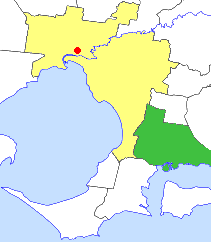
Carrum Downs is a suburb in Melbourne, Victoria, Australia, 36 km south-east of Melbourne's Central Business District, located within the City of Frankston local government area. Carrum Downs recorded a population of 21,976 at the 2021 census.

Patterson Lakes is a suburb in Melbourne, Victoria, Australia, 35 km (22 mi) south-east of Melbourne's Central Business District, located within the City of Kingston local government area. Patterson Lakes recorded a population of 7,793 at the 2021 census.
The Boonwurrung people are an Aboriginal people of the Kulin nation, who are the traditional owners of the land from the Werribee River to Wilsons Promontory in the Australian state of Victoria. Their territory includes part of what is now the city and suburbs of Melbourne. They were called the Western Port or Port Philip tribe by the early settlers, and were in alliance with other tribes in the Kulin nation, having particularly strong ties to the Wurundjeri people.

Melbourne is Australia's second largest city and widely considered to be a garden city, with Victoria being nicknamed "the Garden State". Renowned as one of the most livable cities in the world, there is an abundance of parks, gardens and green belts close to the CBD with a variety of common and rare plant species amid landscaped vistas, pedestrian pathways, and tree-lined avenues, all managed by Parks Victoria.

The Dandenong Creek Trail is a shared use path for cyclists and pedestrians, which follows Dandenong Creek through the outer eastern and south-eastern suburbs of Melbourne, Victoria, Australia.

The Patterson River is a partly man-made urban river of the Port Phillip catchment in the Australian east coast state of Victoria, located in the outer southeastern suburbs of the Greater Melbourne region. Under the name "Patterson", it is the shortest river in Victoria at only 5 km (3.1 mi) in length, although its main stem tributary and de facto upper section, the Dandenong Creek, is over 53 km (33 mi) long.
The City of Cranbourne was a local government area about 45 kilometres (28 mi) southeast of Melbourne, the state capital of Victoria, Australia. The city covered an area of 755 square kilometres (291.5 sq mi), and existed from 1860 until 1994. It was notable for being the last local government area to be declared a city prior to the large-scale amalgamations of 1994 – its former designation was the Shire of Cranbourne.

The City of Chelsea was a local government area about 30 kilometres (19 mi) south of Melbourne, the state capital of Victoria, Australia, on the eastern side of Port Phillip. The city covered an area of 12.23 square kilometres (4.72 sq mi), and existed from 1920 until 1994.

The City of Springvale was a local government area about 30 kilometres (19 mi) southeast of Melbourne, the state capital of Victoria, Australia. The city covered an area of 97.60 square kilometres (37.68 sq mi), and existed from 1857 until 1994.

Melbourne is the capital city of southeastern Australian state of Victoria and also the nation's second most populous city, and has been consistently voted one of the most liveable cities in the world. Located on the northern/eastern coastal plains of Port Phillip Bay, the city is the one of the drier capital cities in Australia, but due to its relatively flat terrain and the runoffs fed from surrounding highlands, still has many lakes, ponds and wetlands, mainly managed by Melbourne Water and Parks Victoria. The larger waterbodies are used for water sports, mostly boating but some are used for recreational activities like swimming, water skiing or model boating.

The Edithvale-Seaford Wetlands is a collection of principally freshwater swamps and marshlands totalling 261 hectares in southeastern Melbourne, Victoria, Australia, about 30 km (19 mi) southeast of Melbourne CBD. It is the largest natural wetland of its type in the Port Phillip and Western Port basins, and is all that remains of the historic Carrum Carrum Swamp, which once covered more than 4,000 hectares from present-day Mordialloc in the north to Frankston in the south.
Jim Allen is an Australian archaeologist specialising in the archaeology of the South Pacific.
The Keilor archaeological site was among the first places to demonstrate the antiquity of Aboriginal occupation of Australia when a cranium, unearthed in 1940, was found to be nearly 15,000 years old. Subsequent investigations of Pleistocene alluvial terraces revealed hearths about 31,000 years BP, making Keilor one of the earliest sites of human habitation in Australia. Remains of megafauna suggest a possible association with Aboriginal hunting.
David Frankel is Emeritus Professor in Archaeology, Faculty of Humanities and Social Sciences, Department of Archaeology and History at La Trobe University.

Aboriginal sites of Victoria form an important record of human occupation for probably more than 40,000 years. They may be identified from archaeological remains, historical and ethnographic information or continuing oral traditions and encompass places where rituals and ceremonies were performed, occupation sites where people ate, slept and carried out their day to day chores, and ephemeral evidence of people passing through the landscape, such as a discarded axe head or isolated artefact.
The Mudgegonga rock shelter is a large rock overhang which contains over 400 Aboriginal wall paintings and stencils and evidence of prehistoric Aboriginal occupation. The site is located in north eastern Victoria near the town of Mudgegonga, and is associated with rich artefact deposits that shows occupation of the region by 3,500 years ago and may have been used several thousand years before this. It has been described as one of the richest rock art sites in Victoria.
The Tarragal Caves are a network of large limestone caves and rockshelters which overlook the Bridgewater Lakes near the towns of Tarragal and Cape Bridgewater, Victoria in the Charles La Trobe and are near Discovery Bay Coastal Park. The caves were identified as important Aboriginal camping places early in the historic period, and were excavated in the late 1970s by Harry Lourandos, revealing stratified deposits in the floor of 11,300 years old, along with shell midden deposits and earth ovens over 11,000 years old.

Tachylite is an unusual and relatively rare stone used in making flaked stone tools, and which is found in Aboriginal archaeological sites in Victoria, Australia.
References
- ↑ "Bend Road Archaeological Excavations (a major consultancy conducted by the La Trobe University Archaeology Program for Eastlink/TJH) 2005-2006". Archived from the original on 18 May 2012. Retrieved 11 December 2011.
- ↑ Report on Bend Road archaeological investigations: Bend Road 1 phases 1 to 3, Jim Allen, Josara de Lange, Geoff Hewitt, Theiss John Holland (Firm), Archaeology Program, La Trobe University, 2008
- ↑ "Hewitt, Geoff & Jim Allen, 'Site Disturbance and Archaeological Integrity: The Case of Bend Road, an Open Site in Melbourne Spanning Pre-LGM Pleistocene to Late Holocene Periods', Australian Archaeology, Issue 70 (June 2010), pp 1-16". Archived from the original on 5 February 2010. Retrieved 11 December 2011.
- ↑ Tim Stone in responses to reviews by Allen and Ranson of the ‘Draft Final Jordan River Levee Report’ (Robert Paton Archaeological Studies Pty Ltd