Biik wurrdha means 'land of many' in Woi-wurrung language and is the Traditional Owners' name assigned for Jacksons Creek. It is understood by Wurundjeri Woi-wurrung people today as a cultural landscape of many interrelated elements.[2][3]
Description and identification
Aboriginal earth (or rock) rings in Australia are only known to occur in Queensland, New South Wales (NSW) and Victoria. It is estimated that over 400 rings once existed in NSW and Queensland, but only a quarter remain today. Many rings were destroyed following European colonisation, and land development, and those that do remain are vulnerable and fragile.[4]
The Sunbury earth rings were formed by scraping off grass and topsoil, and piling it in a circular ridge around the outside. They measure between 10 – 25 m diameter. Three of the rings are in close proximity and two others several kilometres away. All are on gently sloping sites. They are somewhat different from the Bora Rings found in New South Wales and southeast Queensland, which tend to be located in hidden, flat sites, and in connected pairs.[5]
The Sunbury Earth Rings first came to public attention, and first were investigated and described in the early 1970s, when archaeologist Dr. David Frankel undertook a test excavation on one of the rings to determine their origin. Excavations revealed the remains of two small stone cairns, one in the centre and one on the edge of the circle, and a number of sharp stone blades or knives, which may have been used in ritual scarification or circumcision ceremonies.[6]
Interpretation
Recent archaeological investigations have reanalysed the stone artefacts and re-excavated one of Frankel's excavation trenches which crossed the earth mound on the outside of the Sunbury Ring G.[4]
Residue and use wear analysis showed that some of the tools may have been used for cutting animal skin, or possibly for ceremonial scarification. One tool had evidence for possible cutting of feathers.
OSL dating of the soil layers forming the raised edge of the ring indicate it was made between 590 and 1,400 years ago.[4]
Management and conservation
Some of the Rings have been put under the management of the Wurundjeri Woi-wurrung Cultural Heritage Aboriginal Corporation[7] and have also been included on the Register of the National Estate.[8] Several of the Sunbury Earth Rings are located and protected within the Jacksons Creek biik wurrdha Regional Parklands and in other open space reserves.
There are ongoing pressures on the sites from development. As a result of housing development along Reservoir Road, one ring in Fullwood Drive is now encircled by the back fences of adjoining houses, while another is subject to residential subdivision plans which will also see it surrounded by roads. A past proposal even considered incorporating one of the rings in the middle of a traffic round-about. The Canterbury Hills housing estate has submitted plans for residential development around the Riddells Road ring.[9] In October 2009, the Sunbury Maribyrnong Valley Green Wedge Defenders made a Submission to the Parliamentary, Legislative Council regarding their inquiry into the impact of the state government's decision to change the Urban Growth Boundary, citing the Aboriginal ring as a significant element of the threatened Bundanoon woodlands and grasslands, which was being encroached upon by housing.[10][11]
Views of the rings c2004
Hopbush Avenue Ring
Correa Way Ring
Wirilda Court Ring
Reservoir Road ring
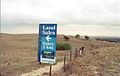
Riddells Road Ring (on far left) with sign indicating future residential development
↑ Meyer Eidelson, The Melbourne Dreaming: A Guide to the Aboriginal Places of Melbourne, Aboriginal Studies Press, Canberra, (1997; 2000). ISBN0-85575-306-4
↑ Parkland Partners (September 2022). Jacksons Creek biik wurrdha Regional Parklands Plan 2022(PDF). Wurundjeri Woi-wurrung Cultural Heritage Aboriginal Corporation, Department of Land, Water and Planning, Hume City Council, Parks Victoria, Melbourne Water, Greater Western Water. Department of Environment, Energy and Climate Action – via www.exploreoutdoors.vic.gov.au.
↑ Frankel, David 1982 Earth rings at Sunbury, Victoria. Archaeology in Oceania 17:83-89. Frankel, David 1991 remains to be Seen (Longman Cheshire). David Frankel, 2017 Between the Murray and the Sea (Sydney University Press)
This page is based on this Wikipedia article Text is available under the CC BY-SA 4.0 license; additional terms may apply. Images, videos and audio are available under their respective licenses.