Berville | |
---|---|
The church in Berville | |
Coordinates: 49°42′36″N0°50′00″E / 49.71°N 0.8333°E Coordinates: 49°42′36″N0°50′00″E / 49.71°N 0.8333°E | |
Country | France |
Region | Normandy |
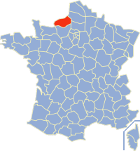
Department | Seine-Maritime |
Arrondissement | Rouen |
Canton | Yvetot |
Intercommunality | CC Plateau de Caux-Doudeville-Yerville |
Government | |
• Mayor (2012-2014) | François-Marie Berger |
Area 1 | 6.72 km2 (2.59 sq mi) |
Population (2009)2 | 544 |
• Density | 81/km2 (210/sq mi) |
Time zone | UTC+01:00 (CET) |
• Summer (DST) | UTC+02:00 (CEST) |
INSEE/Postal code | 76087 /76560 |
Elevation | 123–164 m (404–538 ft) (avg. 150 m or 490 ft) |
1 French Land Register data, which excludes lakes, ponds, glaciers > 1 km2 (0.386 sq mi or 247 acres) and river estuaries. 2 Population without double counting : residents of multiple communes (e.g., students and military personnel) only counted once. |
Berville, also Berville-en-Caux, is a commune in the Seine-Maritime department in the Normandy region in north-western France.
The commune is a level of administrative division in the French Republic. French communes are analogous to civil townships and incorporated municipalities in the United States and Canada, Gemeinden in Germany or comuni in Italy. The United Kingdom has no exact equivalent, as communes resemble districts in urban areas, but are closer to parishes in rural areas where districts are much larger. Communes are based on historical geographic communities or villages and are vested with significant powers to manage the populations and land of the geographic area covered. The communes are the fourth-level administrative divisions of France.
Seine-Maritime is a department of France in the Normandy region of northern France. It is situated on the northern coast of France, at the mouth of the Seine, and includes the cities of Rouen and Le Havre. Until 1955 it was named Seine-Inférieure.
In the administrative divisions of France, the department is one of the three levels of government below the national level, between the administrative regions and the commune. Ninety-six departments are in metropolitan France, and five are overseas departments, which are also classified as regions. Departments are further subdivided into 334 arrondissements, themselves divided into cantons; the last two have no autonomy, and are used for the organisation of police, fire departments, and sometimes, elections.
A farming village situated in the Pays de Caux, some 30 miles (48 km) northwest of Rouen, at the junction of the D67 and the D27 roads.
The Pays de Caux is an area in Normandy occupying the greater part of the French département of Seine Maritime in Normandy. It is a chalk plateau to the north of the Seine Estuary and extending to the cliffs on the English Channel coast; its coastline is known as the Côte d'Albâtre. In the east, it borders on the Pays de Bray where the strata below the chalk show through.
Rouen (
Year | 1962 | 1968 | 1975 | 1982 | 1990 | 1999 | 2006 | 2009 |
---|---|---|---|---|---|---|---|---|
Population | 369 | 380 | 411 | 419 | 473 | 480 | 541 | 544 |
From the year 1962 on: No double counting—residents of multiple communes (e.g. students and military personnel) are counted only once. |
The following is a list of the 711 communes of the French department of Seine-Maritime.
Normandy is one of the 18 regions of France, roughly referring to the historical Duchy of Normandy.
Saint-Riquier-ès-Plains is a commune in the Seine-Maritime department in the Normandy region in northern France.
Ancretiéville-Saint-Victor is a commune in the Seine-Maritime department in the Normandy region in northern France.
Saint-Maclou-de-Folleville is a commune in the Seine-Maritime department in the Normandy region in northern France.
Saint-Mards is a commune in the Seine-Maritime department in the Normandy region in northern France.
Saint-Martin-aux-Arbres is a commune in the Seine-Maritime department in the Normandy region in northern France.
Saint-Ouen-du-Breuil is a commune in the Seine-Maritime department in the Normandy region in northern France.
Saint-Sauveur-d’Émalleville is a commune in the Seine-Maritime department in the Normandy region in northern France.
Saint-Vaast-Dieppedalle is a commune in the Seine-Maritime department in the Normandy region in northern France.
Saint-Aubin-de-Crétot is a commune in the Seine-Maritime department in the Normandy region in northern France.
Bertreville-Saint-Ouen is a commune in the Seine-Maritime department in the Normandy region in northern France.
Berville-sur-Seine is a commune in the Seine-Maritime department in the Normandy region in northern France.
Saint-Gilles-de-la-Neuville is a commune in the Seine-Maritime department in the Normandy region in northern France.
Saint-Hellier is a commune in the Seine-Maritime department in the Normandy region in northern France.
Saint-Jacques-d’Aliermont is a commune in the Seine-Maritime department in the Normandy region in northern France.
Saint-Laurent-en-Caux is a commune in the Seine-Maritime department in the Normandy region in northern France.
Saint-Denis-d’Aclon is a commune in the Seine-Maritime department in the Normandy region in north-western France.
Hautot-Saint-Sulpice is a commune in the Seine-Maritime département in the Normandy region in northern France.
Saint-Léonard is a commune in the Seine-Maritime department in the Normandy region in northern France.
The Canton of Yvetot is a canton situated in the Seine-Maritime département and in the Normandy region of northern France.
The communauté de communes Plateau de Caux-Fleur de Lin was created on December 31, 2001 and is located in the Seine-Maritime département of the Normandy region of northern France. It was merged into the new Communauté de communes Plateau de Caux-Doudeville-Yerville in January 2017.
Wikimedia Commons has media related to Berville-en-Caux . |
This Rouen geographical article is a stub. You can help Wikipedia by expanding it. |