
Oregon City is the county seat of Clackamas County, Oregon, United States, located on the Willamette River near the southern limits of the Portland metropolitan area. As of the 2020 census, the city population was 37,572. Established in 1829 by the Hudson's Bay Company, in 1844 it became the first U.S. city west of the Rocky Mountains to be incorporated.
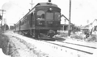
The Oregon Electric Railway (OE) was an interurban railroad line in the U.S. state of Oregon that linked Portland to Eugene. Service from Portland to Salem began in January 1908. The Spokane, Portland and Seattle Railway purchased the system in 1910, and extended service to Eugene in 1912. Regular passenger service in the Willamette Valley ended in May 1933. Freight operations continued and the railway survived into the 1990s, ultimately as a Burlington Northern feeder. Operation as an electric railroad ended July 10, 1945.

Thomas Jay Potter is a former American politician and law enforcement officer in the U.S. state of Oregon. He served as Mayor of Portland from 2005 to 2009, and had been the chief of the Portland Police Bureau. As mayor he continued his advocacy of community policing and expressed interest in other reforms of the Portland police department. He marched against the Iraq War on the first anniversary of American involvement in March 2004 and was dismayed at the black uniforms and the militarized appearance of the Portland police he saw. He made it part of his campaign to rid the police of such a militarized appearance.

Like transportation in the rest of the United States, the primary mode of local transportation in Portland, Oregon is the automobile. Metro, the metropolitan area's regional government, has a regional master plan in which transit-oriented development plays a major role. This approach, part of the new urbanism, promotes mixed-use and high-density development around light rail stops and transit centers, and the investment of the metropolitan area's share of federal tax dollars into multiple modes of transportation. In the United States, this focus is atypical in an era when automobile use led many areas to neglect their core cities in favor of development along interstate highways, in suburbs, and satellite cities.
Portland is "an international pioneer in transit orientated developments."

Downtown Portland is the central business district of Portland, Oregon, United States. It is on the west bank of the Willamette River in the northeastern corner of the southwest section of the city and where most of the city's high-rise buildings are found.

Oregon Route 43 is an Oregon state highway that runs between the cities of Oregon City and Portland, mostly along the western flank of the Willamette River. While it is technically known by the Oregon Department of Transportation as the Oswego Highway No. 3, on maps it is referred to by its route number or by the various street names it has been given.

Woodstock is a neighborhood located in inner southeast Portland, Oregon, United States.
South Portland is a long, narrow neighborhood just south of Downtown Portland, Oregon, hemmed in between the Willamette River and the West Hills. It stretches from I-405 and the Marquam Bridge on the north, to SW Canby St. and the Sellwood Bridge in the south. The Willamette forms the eastern boundary, and SW Barbur Blvd. most of the western boundary. In addition to Downtown to the north, other bordering neighborhoods are Southwest Hills, Homestead, Hillsdale, and South Burlingame to the west, and Hosford-Abernethy, Brooklyn, and Sellwood-Moreland across the river on the east.

Albina is a historical American city that was consolidated into Portland, Oregon in 1891.

East Portland was a city in the U.S. state of Oregon that was consolidated into Portland in 1891. In modern usage, the term generally refers to the portion of present-day Portland that lies east of 82nd Avenue, most of which the City of Portland annexed in the 1980s and 1990s.

Buckman is a neighborhood in the Southeast section of Portland, Oregon. The neighborhood is bounded by the Willamette River on the west, E Burnside St. on the north, SE 28th Ave. on the east, and SE Hawthorne Blvd. on the south.

The Lents neighborhood in the Southeast section of Portland, Oregon is bordered by SE Powell Blvd. on the north, the Clackamas County line or City of Portland line on the south, SE 82nd Ave. to the west, and roughly SE 112th on the east. The NE corner overlaps with the Powellhurst-Gilbert neighborhood. In addition to Powellhurst-Gilbert on the north and east, Lents also borders Foster-Powell, Mt. Scott-Arleta, and Brentwood-Darlington on the west and Pleasant Valley on the east.
University Park is a neighborhood in the north section of Portland, Oregon on the east shore of the Willamette River. University Park is bounded by North Lombard Street and the Portsmouth neighborhood to the north, North Chautauqua Boulevard and the Arbor Lodge neighborhood to the east, The Willamette River and Mock's Bottom industrial area to the south, and the North Portland railroad cut with Cathedral Park and St. Johns neighborhoods to the west.

Foster-Powell is a neighborhood in the Southeast section of Portland, Oregon. The triangular neighborhood is bounded by three major transit arteries: Powell Boulevard to the north, Foster Road to the south, and 82nd Avenue to the east.

Johnson Creek is a 25-mile (40 km) tributary of the Willamette River in the Portland metropolitan area of the U.S. state of Oregon. Part of the drainage basin of the Columbia River, its catchment consists of 54 square miles (140 km2) of mostly urban land occupied by about 180,000 people as of 2012. Passing through the cities of Gresham, Portland, and Milwaukie, the creek flows generally west from the foothills of the Cascade Range through sediments deposited by glacial floods on a substrate of basalt. Though polluted, it is free-flowing along its main stem and provides habitat for salmon and other migrating fish.

The Springwater Corridor Trail is a bicycle and pedestrian rail trail in the Portland metropolitan area in Oregon, United States. It follows a former railway line from Boring through Gresham to Portland, where it ends south of the Eastbank Esplanade. Most of the corridor, about 21 miles (34 km) long, consists of paved, off-street trail, though about 1 mile (1.6 km) overlaps city streets in Portland's Sellwood neighborhood. A large segment roughly follows the course of Johnson Creek and crosses it on bridges many times. Much of the corridor was acquired by the City of Portland in 1990; remaining segments were acquired by Metro thereafter.

Balch Creek is a 3.5-mile (5.6 km) tributary of the Willamette River in the U.S. state of Oregon. Beginning at the crest of the Tualatin Mountains, the creek flows generally east down a canyon along Northwest Cornell Road in unincorporated Multnomah County and through the Macleay Park section of Forest Park, a large municipal park in Portland. At the lower end of the park, the stream enters a pipe and remains underground until reaching the river. Danford Balch, after whom the creek is named, settled a land claim along the creek in the mid-19th century. After murdering his son-in-law, he became the first person legally hanged in Oregon.
The East Portland Grand Avenue Historic District, located in southeast Portland, Oregon, is listed on the National Register of Historic Places. The district includes approximately 20 city blocks on or near Southeast Grand Avenue on the east side of the Willamette River, roughly bounded on the south by SE Main Street, north by SE Ankeny Street, west by SE Martin Luther King Jr. Boulevard, and east by SE Seventh Avenue. Most structures in the district are commercial buildings rising two to three stories. Immediately to the west of the historic district is Portland's east side industrial area, and to the east are industrial and residential areas.
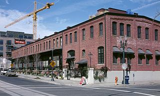
The North Bank Depot Buildings, in central Portland, Oregon, United States, are a pair of buildings formerly used as a freight warehouse and passenger terminal for the Spokane, Portland and Seattle Railway (SP&S). Formed in 1905, the SP&S was commonly known as the North Bank Road during the period in which these buildings were in use. The Portland buildings' passenger facilities were also used by the Oregon Electric Railway after that railway was acquired by the SP&S. Located in what is now known as the Pearl District, the buildings were listed on the National Register of Historic Places in 1996. They were in use by the SP&S and its successor, Burlington Northern Railroad, from 1908 until the 1980s. Only the east building was used as a passenger station, and this usage lasted from 1908 until 1931.
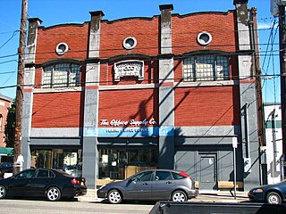
The Henry Kuehle Investment Property, also known as the Gottsacker Grocery Building, in southeast Portland in the U.S. state of Oregon is a two-story commercial building listed on the National Register of Historic Places. Built in Bungalow/Craftsman style in 1909, it was added to the register in 1989.
