Saint Andrews Bay is a bight 2 miles (3.2 km) wide, indenting the north coast of South Georgia immediately south of Mount Skittle. Probably first sighted by the British expedition under Cook which explored the north coast of South Georgia in 1775. The name dates back to at least 1920 and is now well established. On charts where abbreviations are used, the name may be abbreviated to St. Andrews Bay.

Salisbury Plain is a broad coastal plain found with the Bay of Isles on the north coast of South Georgia. It lies between the mouths of Grace and Lucas glaciers on the southern coast of the bay, with Mount Ashley south of it. Best known as the breeding site for as many as 60,000 King penguins, its beaches are also covered with many Southern elephant seals and Antarctic fur seals.
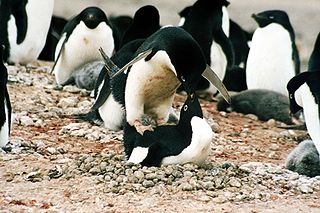
Foyn Island, also known as Svend Foyn Island, is the second largest island in the Possession Islands, East Antarctica, lying 6 kilometres (4 mi) south-west of Possession Island. An Adélie penguin rookery covers much of the island, which is often included in the itinerary of Antarctic cruises.

Dibble Glacier in Antarctica is a prominent channel glacier flowing from the continental ice and terminating in a prominent tongue at the east side of Davis Bay. It was delineated from air photos taken by U.S. Navy Operation Highjump (1946–47), and named by the Advisory Committee on Antarctic Names for Jonas Dibble, ship's carpenter on the sloop Peacock of the United States Exploring Expedition (1838–42) under Charles Wilkes. Dibble is credited with leaving his sick bed and working 24 hours without relief with other carpenters to repair a broken rudder on the Peacock, when the ship was partially crushed in an ice bay in 151°19′E and forced to retire northward.
Lucinda Catherine "Cindy" Buxton FRGS is a British wildlife film-maker, photographer and author.

Baudissin Glacier is a tidewater glacier on the north side of Heard Island. in the southern Indian Ocean. Located 1 nautical mile (1.9 km) west of Challenger Glacier, Baudissin Glacier is 1.5 nautical miles (2.8 km) wide and flows into the western part of Corinthian Bay. The terminus of Baudissin Glacier is located at the western side of Corinthian Bay, at Sealers Cove. To the east of Baudissin Glacier is Challenger Glacier, whose terminus is located at the eastern side of Corinthian Bay, close west to Saddle Point. To the south of Baudissin Glacier is Schmidt Glacier, and to the northwest is Atlas Cove. Kildalkey Head is west of Schmidt Glacier. To the south of Schmidt Glacier is Vahsel Glacier, whose terminus is at South West Bay, between Erratic Point and Cape Gazert. Immediately south of Vahsel Glacier is Allison Glacier. Click here to see a map of Baudissin Glacier and the northwestern coast of Heard Island.
Bogen Glacier is a small glacier on the north side of Drygalski Fjord between Trendall Crag and Hamilton Bay, at the southeast end of South Georgia. It was named by the UK Antarctic Place-Names Committee in 1979 after Arne Bogen, Norwegian sealer working in South Georgia after 1950; Master of the sealing vessel Albatross and Station Foreman, Grytviken.
Challenger Glacier is a tidewater glacier on the north side of Heard Island in the southern Indian Ocean. Located 1 nautical mile (2 km) east of Baudissin Glacier, Challenger Glacier is 0.8 nautical miles (1.5 km) wide and flows into the eastern side of Corinthian Bay, close west to Saddle Point. To the east of Challenger Glacier is Downes Glacier, whose terminus is located at Mechanics Bay, between Saddle Point and Cape Bidlingmaier. To the west of Challenger Glacier is Baudissin Glacier, whose terminus is located at the western side of Corinthian Bay, near Sealers Cove.
Stephenson Glacier is a glacier close west of Dovers Moraine on the east side of Heard Island in the southern Indian Ocean. Its terminus is between Dovers Moraine and Stephenson Lagoon, with part of the glacier flowing to Doppler Hill and Sealers Beach. To the north of Stephenson Glacier is Brown Glacier, whose terminus is located at Brown Lagoon. To the southwest of Stephenson Glacier is Winston Glacier, whose terminus is located at Winston Lagoon, between Cape Lockyer and Oatt Rocks.
Deacock Glacier is a glacier close west of Lavett Bluff on the south side of Heard Island in the southern Indian Ocean. Its terminus is between Cape Labuan and Long Beach. To the east of Deacock Glacier is Fiftyone Glacier, whose terminus is located between Lavett Bluff and Lambeth Bluff. To the west of Deacock Glacier is Gotley Glacier, whose terminus is located between Cape Arkona and Cape Labuan.
Winston Glacier is a glacier flowing to Winston Lagoon on the southeast side of Heard Island in the southern Indian Ocean. Its terminus is at Winston Lagoon, between Cape Lockyer and Oatt Rocks. To the northeast of Winston Glacier is Stephenson Glacier, the terminus of which is located between Dovers Moraine and Stephenson Lagoon. To the southwest of Winston Glacier is Fiftyone Glacier, whose terminus is located between Lavett Bluff and Lambeth Bluff.
Fiftyone Glacier is a large glacier flowing southwards, on the south side of Heard Island in the southern Indian Ocean. Its terminus is located between Lavett Bluff and Lambeth Bluff. To the northeast of Fiftyone Glacier is Winston Glacier, whose terminus is located at Winston Lagoon, between Cape Lockyer and Oatt Rocks. To the west of Fiftyone Glacier is Deacock Glacier, whose terminus is located between Cape Labuan and Long Beach.
Downes Glacier is a broad tidewater glacier on the north side of Heard Island in the southern Indian Ocean. It flows north on both sides of Cape Bidlingmaier to the north coast of Heard Island. To the east of Downes Glacier is Ealey Glacier, whose terminus is located close southeast of Cape Bidlingmaier. To the west of Downes Glacier is Challenger Glacier, whose terminus is located at the eastern side of Corinthian Bay, close west to Saddle Point. Saddle Point separates Downes Glacier from Challenger Glacier.
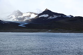
Heaney Glacier is a glacier, 4 nautical miles (7 km) long, which lies close northwest of Cook Glacier and flows northeast and then east toward Saint Andrews Bay on the north coast of South Georgia. It was surveyed by the South Georgia Survey, 1951–52, and named by the UK Antarctic Place-Names Committee for John B. Heaney, a surveyor with that expedition.
Vahsel Glacier is a glacier on the northwestern side of Heard Island in the southern Indian Ocean. It flows west into South West Bay, between Erratic Point and Cape Gazert. Immediately to the north of Vahsel Glacier is Schmidt Glacier, whose terminus is located between Mount Drygalski and North West Cornice. To the south of Vahsel Glacier is Allison Glacier, whose terminus is located south of Cape Gazert, which separates Allison Glacier from Vahsel Glacier.
Schmidt Glacier is a glacier, 0.7 nautical miles (1.3 km) long, flowing west from Baudissin Glacier between Mount Drygalski and North West Cornice, on the west side of Heard Island in the southern Indian Ocean. To the north of Schmidt Glacier is Baudissin Glacier, whose terminus is located at the western side of Corinthian Bay, near Sealers Cove. Kildalkey Head is west of Schmidt Glacier. To the south of Schmidt Glacier is Vahsel Glacier, whose terminus is at South West Bay, between Erratic Point and Cape Gazert. Immediately south of Vahsel Glacier is Allison Glacier. Click here to see a map of Schmidt Glacier and the northwestern coast of Heard Island.
Ealey Glacier is a glacier, flowing northeast from the lower slopes of the Big Ben massif to the northeast side of Heard Island in the southern Indian Ocean. Its terminus is located close southeast of Cape Bidlingmaier, between Melbourne Bluff and North Barrier. The glacier terminates in ice cliffs. To the southeast of Ealey Glacier is Compton Glacier, whose terminus is located at Compton Lagoon, between Gilchrist Beach and Fairchild Beach. To the west of Ealey Glacier is Downes Glacier, whose terminus is located at Mechanics Bay, between Saddle Point and Cape Bidlingmaier.
Arthurson Ridge is a short coastal ridge or promontory, a northern extension from the Wilson Hills, rising between Cook Ridge and the terminus of McLeod Glacier at the head of Davies Bay, Antarctica. It was photographed from aircraft of U.S. Navy Operation Highjump, 1946–47, and first visited by an Australian National Antarctic Research Expeditions (ANARE) airborne field party in March 1961. It was named for J. Arthurson, helicopter pilot with ANARE on the MV Magga Dan in 1961.

The Edwards Islands are a group of about 20 small islands, mostly ice free in summer, lying off the south-western tip of the Canisteo Peninsula, which projects into the eastern Amundsen Sea between Cranton and Ferrero Bays, on the Walgreen Coast of Marie Byrd Land, Antarctica. They were plotted from air photos taken by U.S. Navy Squadron VX-6 in January 1960, and were named by the Advisory Committee on Antarctic Names for Z T Edwards, chief quartermaster on the USS Glacier during the U.S. Navy Bellingshausen Sea Expedition to this area in February 1960.
Thurston Glacier is a glacier about 28 km (17 mi) long which drains the south-eastern slopes of Mount Siple on Siple Island. The glacier trends eastward and then east-north-eastward to reach the northern shore of the island. It was mapped by the United States Geological Survey (USGS) from surveys and United States Navy aerial photography, 1959–65.
