"},"population_est":{"wt":"10254"},"population_rank":{"wt":""},"population_density_km2":{"wt":"871.65"},"population_density_sq_mi":{"wt":"2257.57"},"population_metro_footnotes":{"wt":""},"population_metro":{"wt":""},"population_density_metro_km2":{"wt":""},"population_density_metro_sq_mi":{"wt":""},"population_density":{"wt":""},"population_density_rank":{"wt":""},"population_blank1_title":{"wt":""},"population_blank1":{"wt":""},"population_density_blank1_km2":{"wt":""},"population_density_blank1_sq_mi":{"wt":""},"population_blank2_title":{"wt":""},"population_blank2":{"wt":""},"population_density_blank2_km2":{"wt":""},"population_density_blank2_sq_mi":{"wt":""},"population_demonym":{"wt":""},"population_note":{"wt":""},"demographics_type1":{"wt":""},"demographics1_footnotes":{"wt":""},"demographics1_title1":{"wt":""},"demographics1_info1":{"wt":""},"demographics_type2":{"wt":""},"demographics2_footnotes":{"wt":""},"demographics2_title1":{"wt":""},"demographics2_info1":{"wt":""},"timezone1":{"wt":"[[North American Eastern Time Zone|Eastern (EST)]]"},"utc_offset1":{"wt":"−5"},"timezone1_DST":{"wt":"Eastern Daylight Time"},"utc_offset1_DST":{"wt":"−4"},"timezone2":{"wt":""},"utc_offset2":{"wt":""},"timezone2_DST":{"wt":""},"utc_offset2_DST":{"wt":""},"postal_code_type":{"wt":"[[ZIP Code]]s"},"postal_code":{"wt":"14424, 14425"},"postal2_code_type":{"wt":""},"postal2_code":{"wt":""},"area_code_type":{"wt":""},"area_code":{"wt":"[[Area code 585|585]]"},"geocode":{"wt":""},"iso_code":{"wt":""},"blank_name":{"wt":"[[Federal Information Processing Standards|FIPS code]]"},"blank_info":{"wt":"36-069-12144"},"blank1_name":{"wt":""},"blank1_info":{"wt":""},"blank2_name":{"wt":""},"blank2_info":{"wt":""},"blank_name_sec2":{"wt":"[[Federal Information Processing Standards|FIPS code]]"},"blank_info_sec2":{"wt":"36-12144"},"blank1_name_sec2":{"wt":"[[Geographic Names Information System|GNIS]] feature ID"},"blank1_info_sec2":{"wt":"0945739"},"blank2_name_sec2":{"wt":"Wikimedia Commons"},"blank2_info_sec2":{"wt":"Canandaigua (city), New York"},"website":{"wt":"[http://canandaigua.govoffice.com City of Canandaigua]"},"footnotes":{"wt":""}},"i":0}}]}" id="mwAw">City in New York, United States
Canandaigua | |
---|---|
![]() View north along Main Street, 2014 | |
Etymology: "Ganandogan", Tuscarora for "the chosen spot" | |
Coordinates: 42°53′15″N77°16′54″W / 42.88750°N 77.28167°W Coordinates: 42°53′15″N77°16′54″W / 42.88750°N 77.28167°W | |
Country | United States |
State | New York |
County | Ontario |
Incorporation as village | 1815 |
Incorporation as city | 1913 |
Government | |
• Type | Council–Manager |
• City Manager | John Goodwin |
• Mayor | Ellen Polimeni (D) |
Area | |
• Total | 4.85 sq mi (12.55 km2) |
• Land | 4.59 sq mi (11.90 km2) |
• Water | 0.25 sq mi (0.66 km2) |
Elevation | 750 ft (230 m) |
Lowest elevation | 690 ft (210 m) |
Population (2010) | |
• Total | 10,545 |
• Estimate (2018) [2] | 10,254 |
• Density | 2,257.57/sq mi (871.65/km2) |
Time zone | UTC−5 (Eastern (EST)) |
• Summer (DST) | UTC−4 (Eastern Daylight Time) |
ZIP Codes | 14424, 14425 |
Area code(s) | 585 |
FIPS code | 36-069-12144 |
FIPS code | 36-12144 |
GNIS feature ID | 0945739 |
Wikimedia Commons | Canandaigua (city), New York |
Website | City of Canandaigua |
Canandaigua /ˌkænənˈdeɪɡwə/ (Utaʼnaráhkhwaʼ [3] in Tuscarora) is a city in Ontario County, New York, United States. The population was 10,545 at the 2010 census. It is the county seat of Ontario County; some administrative offices are at the county complex in the adjacent town of Hopewell. [4] [5]
The name Canandaigua is derived from the Seneca name of its historic village here, spelled variously Kanandarque, Ganandogan, Ga-nun-da-gwa, or Konondaigua, which was established long before any European Americans came to the area. In a modern transcription, the historic village is rendered as tganǫdæ:gwęh, which means "the chosen spot", or "at the chosen town". [6]
The city lies within the Town of Canandaigua. The City of Canandaigua is on the northern end of Canandaigua Lake, 24 miles (39 km) southeast of Rochester, 68 miles (109 km) west of Syracuse and 93 miles (150 km) east of Buffalo. Parts of six neighboring towns also share the Canandaigua mailing address and 14424 ZIP code.
This section needs additional citations for verification . (January 2017) (Learn how and when to remove this template message) |
Developed near Canandaigua Lake at the site of the historic Seneca village Ganandogan, by the mid-19th century Canandaigua was an important railroad junction and home port for several steamboats that operated on the lake. After the Civil War, local industries included two brick works, the Lisk Manufacturing Company, several mills, and the regionally prominent McKechnie Brewery. The shire town of the original county of western New York, Canandaigua was the site of the trial of Susan B. Anthony in 1873 on charges of voting illegally because only men were allowed to vote.
In the 21st century, the town is a center for business, government, health care, and education. Canandaigua is the home of Constellation Brands, founded as Canandaigua Wine Company which produces Manischewitz wine; Finger Lakes Community College; Thompson Health System; the Constellation Brands – Marvin Sands Performing Arts Center (CMAC); Granger Homestead; The Canandaigua Lady Paddle wheel tour boat; and Sonnenberg Gardens and Mansion State Historic Park. It is also home to one of the largest Wegmans Food Markets [ citation needed ] and the New York Kitchen.
This section needs additional citations for verification . (January 2017) (Learn how and when to remove this template message) |
French explorers Robert de La Salle and René de Bréhant de Galinée visited the region in 1669. They recorded seeing a burning spring known to the Seneca in what is now known as the nearby Town of Bristol. [7] The water of the spring appears to burn as a flame; this is caused by escaping natural gas, and several such burning springs have been noted in the Canandaigua area. [8] [9]
The city was the historic site of Kanandaigua, a Seneca village. The village site was later used for West Avenue Cemetery. The village was formed by former residents of the Ganondagan Seneca village, destroyed by the French in 1687.
The Kanandaigua Seneca village, consisting of 23 longhouses, was destroyed during the American Revolutionary War by the Sullivan Expedition on September 10, 1779. [10] American rebels had mounted this attack in reprisal for an attack by Mohawk and other British allies on Cherry Valley in the eastern part of the territory. The American forces attacked Iroquois villages throughout western New York, destroying 40 and burning the winter stores of the people. The Iroquois fled to Fort Niagara as refugees, and many died of starvation that winter.
After the war, pioneer settlers came from eastern New York and New England. They founded the city's public high school, Canandaigua Academy, in 1791. On November 11, 1794, the Treaty of Canandaigua was signed in the town by representatives of the United States of America and the Six Nations of the Iroquois; the British had ceded Iroquois lands without consulting them, and the US forced most of the Iroquois Native Americans out of the state. It established two small reservations for the Seneca and Oneida, who had been allies of the American rebels, but they suffered considerable enmity and discrimination after the war.
What is now the city separated from the Town of Canandaigua to become the Village of Canandaigua in 1815 and a city in 1913.
In 1807-1808, Jessie Hawley, a flour merchant from Geneva, served 20 months in the Canandaigua debtors' prison. He was an early proponent of building a canal through the Mohawk Valley to improve shipping and connect the Hudson River with Lake Erie. During his time in prison, he published 14 influential essays on the canal concept.[ citation needed ]
Stephen A. Douglas was a student at Canandaigua Academy between 1830 and January 1833; he later moved west and was elected as US senator from Illinois. He was the 1860 Democratic Party presidential nominee, losing to Republican Abraham Lincoln. [11]
This area of New York was a center of activism for women's suffrage and other progressive movements. In 1873, the Ontario County Courthouse, located in the City of Canandaigua, was the site of the trial of Susan B. Anthony, a leader of the women's suffrage movement who was arrested for voting at a time when only men were allowed to vote. She was found guilty and fined $100, which she did not pay. [12]
John Willys was born in Canandaigua in 1873 and operated a bicycle sales and repair shop there, before later becoming a successful automobile manufacturer. [13]
On October 30th, 1900 Theodore Roosevelt Made a brief stop in Canandaigua to give a campaign speech at Atwater park. [14] .
In 1945, Marvin Sands founded Canandaigua Wine Company. With a growing American market for wine in the late 20th century, the company expanded rapidly through acquisitions in the 1980s and 1990s. It joined other companies in forming Constellation Brands and became the world's largest wine and spirits distributor. In 2006, Canandaigua Wine Company rebranded as Centerra Wine Co., a subsidiary of Constellation Wines, U.S., Inc. [15]
On March 14, 2006, President George W. Bush visited Canandaigua, giving speeches at Canandaigua Academy and at Ferris Hills, an assisted-living community for seniors. He was describing Medicare Part D for senior citizens. [16] The text of his speech at Ferris Hills can be found here.
According to the United States Census Bureau, Canandaigua has an area of 4.8 square miles (12.5 km²), of which 4.6 square miles (11.9 km²) is land and 0.2 square mile (0.6 km²) (4.75%) is water.
The city is at the northern end of Canandaigua Lake, in the Finger Lakes region, the largest wine-producing area in New York State.
The city is on U.S. Route 20 and NY Routes 5 and 21.
Climate data for Canandaigua | |||||||||||||
---|---|---|---|---|---|---|---|---|---|---|---|---|---|
Month | Jan | Feb | Mar | Apr | May | Jun | Jul | Aug | Sep | Oct | Nov | Dec | Year |
Average high °F (°C) | 34 (1) | 36 (2) | 43 (6) | 55 (13) | 68 (20) | 77 (25) | 81 (27) | 79 (26) | 72 (22) | 61 (16) | 48 (9) | 37 (3) | 58 (14) |
Daily mean °F (°C) | 27 (−3) | 27 (−3) | 36 (2) | 46 (8) | 57 (14) | 66 (19) | 72 (22) | 70 (21) | 63 (17) | 52 (11) | 43 (6) | 30 (−1) | 49 (9) |
Average low °F (°C) | 18 (−8) | 19 (−7) | 27 (−3) | 36 (2) | 46 (8) | 57 (14) | 63 (17) | 61 (16) | 54 (12) | 43 (6) | 34 (1) | 25 (−4) | 40 (5) |
Average precipitation inches (mm) | 1.81 (46.0) | 1.65 (41.9) | 2.52 (64.0) | 3.12 (79.2) | 2.96 (75.2) | 3.50 (88.9) | 3.80 (96.5) | 3.22 (81.8) | 3.36 (85.3) | 2.99 (75.9) | 2.82 (71.6) | 2.22 (56.4) | 33.96 (862.7) |
Source: [17] |
Historical population | |||
---|---|---|---|
Census | Pop. | %± | |
1810 | 450 | — | |
1830 | 1,830 | — | |
1840 | 2,790 | 52.5% | |
1850 | 3,200 | 14.7% | |
1860 | 4,822 | 50.7% | |
1870 | 4,862 | 0.8% | |
1880 | 5,726 | 17.8% | |
1890 | 5,868 | 2.5% | |
1900 | 6,151 | 4.8% | |
1910 | 7,217 | 17.3% | |
1920 | 7,299 | 1.1% | |
1930 | 7,541 | 3.3% | |
1940 | 8,321 | 10.3% | |
1950 | 8,332 | 0.1% | |
1960 | 9,370 | 12.5% | |
1970 | 10,488 | 11.9% | |
1980 | 10,419 | −0.7% | |
1990 | 10,725 | 2.9% | |
2000 | 11,264 | 5.0% | |
2010 | 10,545 | −6.4% | |
Est. 2018 | 10,254 | [2] | −2.8% |
U.S. Decennial Census [18] |
As of the census of 2010, there were 10,545 people, 4,789 households, and 2,470 families residing in the city. [19]
As of the census [20] of 2000, there were 11,264 people, 4,762 households, and 2,666 families residing in the city in the year 2000 census. The population density was 2,447.5 people per square mile (945.4/km²). There were 5,066 housing units at an average density of 1,100.8 per square mile (425.2/km²). The city's racial makeup was 96.04% White, 1.53% Black or African American, 0.22% Native American, 0.66% Asian, 0.06% Pacific Islander, 0.26% from other races, and 1.23% from two or more races. Hispanic or Latino of any race were 1.02% of the population.
There were 4,762 households out of which 27.1% had children under the age of 18 living with them, 40.7% were married couples living together, 12.2% had a female householder with no husband present, and 44.0% were non-families. 35.4% of all households were made up of individuals and 16.0% had someone living alone who was 65 years of age or older. The average household size was 2.25 and the average family size was 2.95.
In the city, the age distribution of the population shows 23.3% under the age of 18, 8.1% from 18 to 24, 27.7% from 25 to 44, 22.0% from 45 to 64, and 18.9% who were 65 years of age or older. The median age was 39 years. For every 100 females, there were 91.8 males. For every 100 females age 18 and over, there were 87.5 males.
The median income for a household in the city was $37,197, and the median income for a family was $47,388. Males had a median income of $31,950 versus $26,538 for females. The per capita income for the city was $20,153. About 5.9% of families and 9.5% of the population were below the poverty line, including 8.9% of those under age 18 and 8.9% of those age 65 or over.
The Canandaigua City School District serves Canandaigua and the surrounding region. The district includes Canandaigua Academy as its high school.
Within the City of Canandaigua, the following buildings, properties and districts are listed on the National Register of Historic Places:
This section does not cite any sources . (July 2015) (Learn how and when to remove this template message) |
The Finger Lakes are a group of 11 long, narrow, roughly north–south lakes in an area informally called the Finger Lakes region in Central New York, in the United States. This region straddles the northern and transitional edge, known as the Finger Lakes Uplands and Gorges ecoregion, of the Northern Allegheny Plateau and the Ontario Lowlands ecoregion of the Great Lakes Lowlands.
Seneca Lake is the largest of the glacial Finger Lakes of the U.S. state of New York, and the deepest lake entirely within the state. It is promoted as being the lake trout capital of the world, and is host of the National Lake Trout Derby. Because of its depth and relative ease of access, the US Navy uses Seneca Lake to perform test and evaluation of equipment ranging from single element transducers to complex sonar arrays and systems. The lake takes its name from the Seneca nation of Native Americans. At the north end of Seneca Lake is the city of Geneva, New York, home of Hobart and William Smith Colleges and the New York State Agricultural Experiment Station, a division of Cornell University. At the south end of the lake is the village of Watkins Glen, New York, famed for auto racing and waterfalls.
Seneca may refer to:
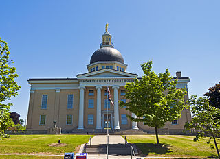
Ontario County is a county in the U.S. State of New York. As of the 2010 census, the population was 107,931. The county seat is Canandaigua.
Seneca County is a county located in the U.S. state of New York. As of the 2010 census, the population was 35,251. The primary county seat is Waterloo, moved there from the original county seat of Ovid in 1819. It became a two-shire county in 1822, which currently remains in effect, using both locations as county seats although the majority of Seneca County administrative offices are located in Waterloo. Therefore, most political sources only list Waterloo as the county seat. The county's name is from the Iroquois (Seneca) that occupied part of the region.
Brockport is a village in the Town of Sweden, with two tiny portions in the Town of Clarkson, in Monroe County, New York, United States. The population was 8,366 at the 2010 census. The name is derived from Heil Brockway, an early settler. It is the home of The College at Brockport, State University of New York (SUNY-Brockport)
Gorham is a town in Ontario County, New York, United States. The population was 4,274 at the 2010 census. The town is named after Nathaniel Gorham.
Hopewell is a town in Ontario County, New York, United States. The population was 3,747 at the 2010 census.
Montour Falls is a village located in Schuyler County, New York, United States. A population of 1,711 was reported by the US Census of 2010. A waterfall at the end of West Main Street gives the village its name. The name "Montour" is derived from Queen Catharine Montour, a prominent Native American woman of Seneca Indian heritage who lived at the village site in the 18th century.
Varick is a town in Seneca County, New York, United States. The population was 1,857 at the 2010 census. The town is named after Richard Varick, an officer in the American Revolution, mayor of New York City, and uncle of the first Town Supervisor, Anthony Dey.
Geneva is a city in Ontario and Seneca counties in the U.S. state of New York. It is at the northern end of Seneca Lake; all land portions of the city are within Ontario County; the water portions are in Seneca County. The population was 13,261 at the 2010 census. The city is supposedly named after the city and canton of Geneva in Switzerland. The main settlement of the Seneca was spelled Zoneshio by early white settlers, and was described as being 2 miles north of Seneca Lake.
Canandaigua is a town in Ontario County, New York, United States. The population was 10,020 at the 2010 census. The name is a native word ("Kah-nan-dah-kwe") for "the chosen spot" or "the chosen place."
Lodi is a town in Seneca County, New York, United States. The population was 1,550 at the 2010 census.
Ovid is a village in and one of the two county seats of Seneca County, New York, United States. The population was 602 at the 2010 census. The town was named by a clerk interested in the classics.
Canandaigua Lake is the fourth largest of the Finger Lakes in the U.S. state of New York. The City of Canandaigua is located at the northern end of the lake and the village of Naples is several miles south of the southern end. Traveling west to east in the Finger Lakes region, it is the first of the major Finger Lakes.
The Cayuga was one of the five original constituents of the Haudenosaunee (Iroquois), a confederacy of Native Americans in New York. The Cayuga homeland lies in the Finger Lakes region along Cayuga Lake, between their league neighbors, the Onondaga to the east and the Seneca to the west. Today Cayuga people belong to the Six Nations of the Grand River First Nation in Ontario, and the federally recognized Cayuga Nation of New York and the Seneca-Cayuga Tribe of Oklahoma.
Victor is a town in Ontario County, New York, United States. The population was 14,275 at the 2010 census. The town is named after Claudius Victor Boughton, an American hero of the War of 1812.
Ganondagan State Historic Site, also known as Boughton Hill, is a Native American historic site in Ontario County, New York in the United States. Location of the largest Seneca village of the 17th century, the site is in the present-day Town of Victor, southwest of the Village of Victor. The village was also referred to in various spellings as Gannagaro, Canagora, Gandagora, and Gandagaro.
Kanadaseaga, was a major village, perhaps a capital, of the Seneca nation of the Iroquois Confederacy in west-central New York State, United States. It was located between the northern ends of Seneca and Canandaigua lakes, one and a half miles northwest of the present-day city of Geneva in the township of Seneca. The village was situated on both sides of Kanadaseaga Creek. The Seneca established this village at least as early as 1687. It was likely established by the former residents of Ganondagan, after its destruction by the French.
Squaw Island is located at the north end of Canandaigua Lake, near the city of Canandaigua, New York, United States. It is one of two islands in the 11 Finger Lakes. Frequently it is described as New York's smallest state park; however, while it is one of the state's smallest protected areas, it is not formally designated as a state park, but rather it is a "unique area" managed by the New York State Department of Environmental Conservation.
![]() | Wikimedia Commons has media related to Canandaigua (city), New York . |
![]() | Wikisource has the text of the 1911 Encyclopædia Britannica article Canandaigua . |
![]() | Wikivoyage has a travel guide for Canandaigua . |