The North London line (NLL) is a railway line which passes through the inner suburbs of west, north-west, north, and north-east London, England between Richmond in the south-west and Stratford in the east, avoiding central London. Its route is a rough semicircle.

The Taff Vale Railway (TVR) was a standard gauge railway in South Wales, built by the Taff Vale Railway Company to serve the iron and coal industries around Merthyr Tydfil and to connect them with docks in Cardiff. It was opened in stages in 1840 and 1841.

Euston is a London Underground station. It directly connects with its National Rail railway station above it. The station is in Travelcard Zone 1.

Watford Junction is a railway station that serves Watford, Hertfordshire. The station is on the West Coast Main Line (WCML), 17 miles 34 chains (28 km) from London Euston and the Abbey Line, a branch line to St Albans. Journeys to London take between 16 and 52 minutes, depending on the service. Trains also run to Clapham Junction and East Croydon, via the West London line. The station is a major hub for local bus services and the connecting station for buses to Warner Bros. Studio Tour London – The Making of Harry Potter. The station is located north of a viaduct over the Colne valley and immediately south of Watford Tunnel.

JFK/UMass station is a Massachusetts Bay Transportation Authority (MBTA) intermodal transfer station, located adjacent to the Columbia Point area of Dorchester, Boston, Massachusetts. It is served by the rapid transit Red Line; the Greenbush Line, Kingston/Plymouth Line, and Middleborough/Lakeville Line of the MBTA Commuter Rail system, and three MBTA bus routes. The station is named for the John F. Kennedy Presidential Library and Museum and the University of Massachusetts Boston, both located nearby on Columbia Point.

Milton, formerly known as Tokomairiro or Tokomairaro, is a town of over 2,000 people, located on State Highway 1, 50 kilometres to the south of Dunedin in Otago, New Zealand. It lies on the floodplain of the Tokomairaro River, one branch of which loops past the north and south ends of the town. This river gives its name to many local features, notably the town's only secondary school, Tokomairiro High School.

Aylesbury railway station is a railway station in Aylesbury, Buckinghamshire, England, on the London–Aylesbury line from London Marylebone via Amersham. It is 38 miles (61 km) from Aylesbury to Marylebone. A branch line from Princes Risborough on the Chiltern Main Line terminates at the station. It was the terminus for London Underground's Metropolitan line until the service was cut back to Amersham in 1961. The station was also known as Aylesbury Town under the management of British Railways from c. 1948 until the 1960s.

Exmouth railway station serves the town of Exmouth in Devon, England and is 11.25 miles (18 km) south of Exeter St Davids, the terminus of the Avocet Line. The station is managed by Great Western Railway, who operate all trains serving it.
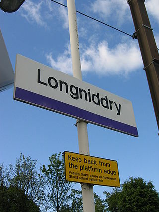
Longniddry railway station is located at the southeast corner of the coastal village of Longniddry, East Lothian, Scotland. The station is on the East Coast Main Line, 13+1⁄4 miles (21.3 km) east of Edinburgh Waverley, and is served by stopping passenger trains on the North Berwick Line.

Oxford railway station is a mainline railway station, one of two serving the city of Oxford, England. It is about 0.5 miles (800 m) west of the city centre, north-west of Frideswide Square and the eastern end of Botley Road. It is the busiest station in Oxfordshire, and the fourth busiest in South East England.

Weston-super-Mare railway station serves the seaside town of Weston-super-Mare in North Somerset, England. It is situated on a loop off the main Bristol to Taunton Line, 137 miles 33 chains from the zero point at London Paddington via Box.

Beaumont is a small town in inland Otago, in the South Island of New Zealand. It is located on the Clutha River / Mata-Au six kilometres southeast of Raes Junction, between Roxburgh and Balclutha. Beaumont is connected to Milton and Roxburgh by State Highway 8.
The Tuatapere Branch, including the Orawia Branch, was a branch line railway in Southland, New Zealand. Although the Tuatapere and Orawia Branches look like a single line, operationally they were considered separate lines. The first section opened to Riverton in 1879 and reached Tuatapere three decades later. The extension from Tuatapere to Orawia operated from 1925 until 1970. In 1976 the Tuatapere Branch was truncated to Riverton, and was known as the Riverton Branch until 1978, when it closed beyond Thornbury. The remaining portion of the line is now part of the Wairio Branch.
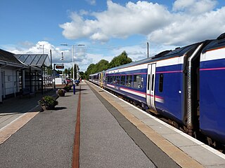
Keith railway station is a railway station serving the town of Keith, Moray, Scotland. The station is managed by ScotRail and is on the Aberdeen to Inverness Line, between Huntly and Elgin, measured 53 miles 8 chains (85.5 km) from Aberdeen, or 30 miles 20 chains (48.7 km) from Forres.
The Roxburgh Branch was a branch line railway built in the Otago region of New Zealand's South Island that formed part of the country's national rail network. Originally known as the Lawrence Branch, it was one of the longest construction projects in New Zealand railway history, beginning in the 1870s and not finished until 1928. The full line was closed in 1968.

The Chertsey branch line is a 5-mile-40-chain (8.9 km) railway line in Surrey, England. It runs from the Waterloo–Reading line at Virginia Water station to a triangular junction with the South West Main Line near Weybridge. There are intermediate stations at Chertsey and Addlestone. All of the stations are managed by South Western Railway, which operates all passenger trains. Most services run between Weybridge and London Waterloo via Hounslow and Clapham Junction. For much of the day, passengers can change to faster services at Virginia Water and Weybridge to reach the capital more quickly.
The Waitara Branch is a 7.245 km long branch line railway in the Taranaki region of New Zealand's North Island. It was built as part of the region's first railway, linking New Plymouth with the closest suitable port, then the river port of Waitara. In 1884 the Breakwater port was opened in New Plymouth, but the line was saved when a (meat) freezing works was opened at Waitara in 1885.

Longburn railway station was a station in Longburn, on the North Island Main Trunk in New Zealand. The platform, which is across from the Fonterra Factory, remains but the structure has been demolished.

Makino Road railway station was a station on the North Island Main Trunk in New Zealand. It was a request stop, 49 mi (79 km) south of Wanganui and 2 mi (3.2 km) north of Feilding.
Paerātā railway station is a railway station under construction in Auckland, New Zealand. It is due to open in 2025 as part of the Auckland railway electrification project. It will serve the Paerata area, linking with the new Paerata Rise housing development. The station will be located on the existing North Island Main Trunk railway line, adjacent to the planned eastern extent of the development.