
Mount Waddington, once known as Mystery Mountain, is the highest peak in the Coast Mountains of British Columbia, Canada. Although it is lower than Mount Fairweather and Mount Quincy Adams, which straddle the United States border between Alaska and British Columbia, Mount Waddington is the highest peak that lies entirely within British Columbia. It and the subrange which surround it, known as the Waddington Range, stand at the heart of the Pacific Ranges, a remote and extremely rugged set of mountains and river valleys.

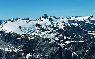
The Waddington Range is a subrange of the Pacific Ranges of the Coast Mountains in southwestern British Columbia, Canada. It is only about 4,000 km2 (1,500 sq mi) in area, relatively small in area within the expanse of the range, but it is the highest area of the Pacific Ranges and of the Coast Mountains, being crowned by its namesake Mount Waddington 4,019 m (13,186 ft). The Waddington Range is also extremely rugged and more a complex of peaks than a single icefield, in contrast to the other huge icefield-massifs of the southern Coast Mountains, which are not so peak-studded and tend to have more contiguous icemasses.

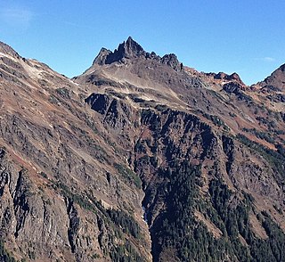
Mount Munday is one of the principal summits of the Pacific Ranges of the Coast Mountains in British Columbia, Canada. It is 3,356 m (11,010 ft) in elevation and stands in the Waddington Range six kilometres southeast of Mount Waddington 4,019 m (13,186 ft), which is the highest summit in the Coast Mountains.

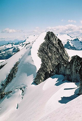
Mount Tiedemann 3,838 m (12,592 ft), prominence 848 m (2,782 ft), is one of the principal summits of the Pacific Ranges subdivision of the Coast Mountains of British Columbia. It is located 3 km (1.9 mi) northeast of Mount Waddington in the Waddington Range massif between the Homathko and Klinaklini Rivers.

Mount Judge Howay, originally the Snow Peaks, is a distinctive twin summit located 10 km (6 mi) from the Central Fraser Valley and, close up, the north end of Stave Lake. Being one of the highest peaks in the region, it is visible from many of the peaks around Vancouver, British Columbia. It is in the eastern part of Golden Ears Provincial Park. Mount Robie Reid is to the south.
Phyllis Beatrice Munday was a Canadian mountaineer, explorer, naturalist and humanitarian. She was famed for being the first woman to reach the summit of Mount Robson in 1924, and with her husband Don for discovering Mount Waddington, and exploring the area around it via the Franklin River and the Homathko River. Munday was awarded the Order of Canada in 1972 for her work with the Girl Guides of Canada and St. John Ambulance, as well as for her mountaineering career.
Walter Alfred Don Munday (1890–1950) was a Canadian explorer, naturalist and mountaineer famous for his explorations of the Coast Mountains with his wife Phyllis, and especially for the exploration of the Waddington Range.
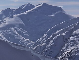
Asperity Mountain is a mountain located in British Columbia, Canada, rising to 3,716 metres (12,192 ft). It is located between Tellot and Tiedemann Glaciers on the north and south respectively, in the Waddington Range, a subrange of the Pacific Ranges. The gorge of the Homathko River runs north to south on the east side of the mountain, carrying runoff from the mountain and glaciers to the Pacific Ocean.

Mount Benvolio is a 2,613-metre (8,573-foot) glacier-clad peak located in the Garibaldi Ranges of the Coast Mountains, in Garibaldi Provincial Park of southwestern British Columbia, Canada. It is the second-highest point of the Fitzsimmons Range, which is a subset of the Garibaldi Ranges. It is situated 15 km (9 mi) southeast of Whistler, and its nearest higher peak is Overlord Mountain, 0.7 km (0 mi) to the northwest. The Benvolio Glacier is set on the western slope of the peak, the Diavolo Glacier spreads out below the eastern aspect of the summit, and the Fitzsimmons Glacier descends the north slope. Precipitation runoff from the peak and meltwater from its glaciers drains into tributaries of the Cheakamus River.
Baby Munday Peak is a 2,250-meter-elevation (7,382-foot) mountain summit located in the Cheam Range of British Columbia, Canada.
Mount Tinniswood is a 2,606-metre (8,550-foot) mountain summit located in British Columbia, Canada.

Grenelle Mountain is a 3,047-metre (9,997-foot) mountain summit located in British Columbia, Canada.

Bravo Peak is a 3,105-metre (10,187-foot) summit located in British Columbia, Canada.

Spearman Peak is a 3,365-metre (11,040-foot) summit located in British Columbia, Canada.
Mount Carr is a 2,590-metre (8,497-foot) mountain summit located in British Columbia, Canada.
Isosceles Peak is a 2,488-metre (8,163-foot) mountain summit located in British Columbia, Canada.
Parapet Peak is a 2,463-metre (8,081-foot) mountain summit located in British Columbia, Canada.

Jubilee Mountain is a 2,751-metre (9,026-foot) mountain summit in British Columbia, Canada.

Mount Sir Richard is a 2,681-metre (8,796-foot) glaciated summit in British Columbia, Canada.

Mount Neal is a 2,552-metre (8,373-foot) glaciated summit in British Columbia, Canada.


