Crookes (ward)

Last updated

Coordinates: 53°23′17″N1°30′18″W / 53.388°N 1.505°W / 53.388; -1.505

Geographic coordinate system Coordinate system

A geographic coordinate system is a coordinate system that enables every location on Earth to be specified by a set of numbers, letters or symbols. The coordinates are often chosen such that one of the numbers represents a vertical position and two or three of the numbers represent a horizontal position; alternatively, a geographic position may be expressed in a combined three-dimensional Cartesian vector. A common choice of coordinates is latitude, longitude and elevation. To specify a location on a plane requires a map projection.

Contents

Crookes & Crosspool
Sheffield-wards-Crooks.png
Shown within Sheffield
Population 16,800 
District
Ceremonial county
Region
Country England
Sovereign state United Kingdom
EU Parliament Yorkshire and the Humber
UK Parliament
Councillors Sheffield City Council
Anne Murphy (Labour Party)
Adam Hanrahan (Liberal Democrats)
Mohammed Mahroof (Liberal Democrats)
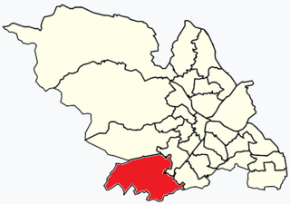
List of places
UK
England
Yorkshire

Crookes & Crosspool wardwhich includes the districts of Crookes , Steelbank, Crosspool, and Sandygate [1] is one of the 28 electoral wards in City of Sheffield, England. It is located in the western part of the city and covers an area of 3.9 km2. The population of this ward in 2011 was 17,700 people in 7,266 households. [2]

Crookes a town in Sheffield, United Kindom

Crookes is a suburb of the City of Sheffield, England, about 1.5 miles (2.4 km) west of the city centre. It borders Broomhill to the south, Walkley and Crookesmoor to the east and open countryside around the River Rivelin to the north. The population of the ward of the same name was 17,700 at the 2011 Census.

Sheffield City and Metropolitan borough in England

Sheffield is a city and metropolitan borough in South Yorkshire, England. Historically part of the West Riding of Yorkshire, its name derives from the River Sheaf, which runs through the city. With some of its southern suburbs annexed from Derbyshire, the city has grown from its largely industrial roots to encompass a wider economic base. The population of the City of Sheffield is 577,800 (mid-2017 est.) and it is one of the eight largest regional English cities that make up the Core Cities Group. Sheffield is the third-largest English district by population. The metropolitan population of Sheffield is 1,569,000.

England Country in north-west Europe, part of the United Kingdom

England is a country that is part of the United Kingdom. It shares land borders with Wales to the west and Scotland to the north-northwest. The Irish Sea lies west of England and the Celtic Sea lies to the southwest. England is separated from continental Europe by the North Sea to the east and the English Channel to the south. The country covers five-eighths of the island of Great Britain, which lies in the North Atlantic, and includes over 100 smaller islands, such as the Isles of Scilly and the Isle of Wight.

The current councillors for Crookes Ward are Labour's Anne Murphy, and the Liberal Democrats’ Adam Hanrahan and Mohammed Mahroof. In the 2004 local elections Sylvia Anginotti, John Hesketh, and Brian Holmes, all Liberal Democrats, were returned as councillors for the newly drawn ward. John Hesketh was defeated by Labour's Geoff Smith in 2011. Crookes ward is located within Sheffield Hallam Parliamentary constituency. The local MP is Labour's Jared O'Mara, who won the seat from Nick Clegg in the general election of June 2017.

Liberal Democrats (UK) Political party in the United Kingdom

The Liberal Democrats are a liberal political party in the United Kingdom. They presently have 11 Members of Parliament in the House of Commons, 96 members of the House of Lords, and one member of the European Parliament. They also have five Members of the Scottish Parliament and a member each in the Welsh Assembly and London Assembly. The party reached the height of its influence in the early 2010s, forming a junior partner in a coalition government from 2010 to 2015. It is presently led by Vince Cable.

Sheffield Hallam (UK Parliament constituency) Parliamentary constituency in the United Kingdom

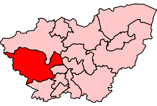
Sheffield Hallam is a constituency represented in the House of Commons of the UK Parliament since 2017 by Jared O'Mara.

Jared OMara British politician

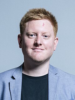
Jared Cain O'Mara is a British politician. He has been the Member of Parliament (MP) for the constituency of Sheffield Hallam since 8 June 2017, and was elected as the Labour candidate.

Districts of Crookes ward

Crookes

Crookes (grid reference SK328877 ) is a suburb of the City of Sheffield, England, about 1.6 miles (2.6 km) west of the city centre. It borders Broomhill to the south, Walkley and Crookesmoor to the east and open countryside around the River Rivelin to the north. It is home to a large student population from the nearby University of Sheffield, and contained the university's Tapton Hall of Residence until this was demolished in 2014.

Ordnance Survey National Grid System of geographic grid references used in Great Britain

The Ordnance Survey National Grid reference system is a system of geographic grid references used in Great Britain, distinct from latitude and longitude. It is often called British National Grid (BNG).

Suburb Human settlement that is part of or near to a larger city

A suburb is a mixed-use or residential area, existing either as part of a city or urban area or as a separate residential community within commuting distance of a city. In most English-speaking countries, suburban areas are defined in contrast to central or inner-city areas, but in Australian English and South African English, suburb has become largely synonymous with what is called a "neighborhood" in other countries and the term extends to inner-city areas. In some areas, such as Australia, India, China, New Zealand, the United Kingdom, and a few U.S. states, new suburbs are routinely annexed by adjacent cities. In others, such as Saudi Arabia, Canada, France, and much of the United States, many suburbs remain separate municipalities or are governed as part of a larger local government area such as a county.

Walkley human settlement in United Kingdom

Walkley is a suburb in the north west of Sheffield in England. It lies west of Burngreave, south of Hillsborough and north-east of Crookes.

Steel Bank

An area of terraced housing in Crookes, Sheffield. Steel Bank is a steep hill that starts from Springvale Road to the South and Northfield Road to the North. It stretches from Western Road to Heavygate Road which borders on the S6 postcode and the Walkley council ward. Roads on Steel Bank are Western Road, Brighton Terrace Road, Melbourn Road, Mona Road, and the very steep Townend Street and Bates Street. Slinn Street sits at the top of Steel Bank. Aldred Road and Bradley Street are also part of the Steel Bank area of Crookes. The name 'Steel Bank' is rarely used, and most would just call the area 'Crookes'. Steel Bank has one pub named 'The Princess Royal'. This is an old local pub situated on Slinn Street.

Sandygate

Sandygate (grid reference SK310867 ) is a residential area on the western tip of Sheffield. It is home to the oldest football ground in the world, Sandygate Road, which has been home to Hallam C.C since 1804 and Hallam F.C. since 1860. Hallamshire Golf Course is also located in the area.

Sandygate Road football and cricket stadium Crosspool, South Yorkshire, England

Sandygate Road is a football and cricket stadium in the Sheffield suburb of Crosspool, South Yorkshire, England. It is home to Hallam F.C. and Hallam C.C.

Hallam F.C. association football club

Hallam Football Club is an English football club based in Crosspool, Sheffield, South Yorkshire. They play in the Northern Counties East League Division One, at level 10 of the English football league system. Founded in 1860, it is second only to local rivals Sheffield F.C. in the list of the oldest association football clubs in the world. Games between these two clubs are known as the Rules derby.

Crosspool

Crosspool is a residential area on the western outskirts of Sheffield. It contains four large schools, Lydgate Junior School, Lydgate Infant School, Tapton School, and King Edward VII Lower School.

Tapton Secondary School is a secondary school with academy status located in Crosspool, in Sheffield, South Yorkshire, England. It is sited next to another secondary, King Edward VII School, and near to Lydgate Junior School, Lydgate Infant School and Notre Dame High School. Tapton School has approximately 1,650 pupils, aged between 11 and 18 years old. Tapton officially opened in 1960, however in 2000, the school was rebuilt under the Private Finance Initiative. Students and faculties officially moved to the new building in September 2001.

Related Research Articles

Ecclesall electoral ward of Sheffield City Council

Ecclesall Ward—which includes the neighbourhoods of Bents Green, Ecclesall, Greystones, Millhouses, and Ringinglow—is one of the 28 electoral wards in City of Sheffield, England. It is located in the southwestern part of the city and covers an area of 3.6 square miles. The population of this ward in 2007 was 19,211 people in 7,626 households, reducing to 6,657 at the 2011 Census. Ecclesall ward is one of the four wards that make up the South West Community Assembly and one of five wards that make up the Sheffield Hallam Parliamentary constituency. The Member of Parliament is Jared O'Mara, member of the Labour Party. Ecclesall is one of the least socially deprived wards in the entire country, with a 2002 deprivation score of 4.7—making it the 8,105th most deprived ward out of 8,414 wards in the country. The demographic consists largely of white, middle-class families.

Broomhill and Sharrow Vale electoral ward of Sheffield City Council

Broomhill and Sharrow Vale — which includes the districts of Broomhill, Broomhall, Crookesmoor, Endcliffe, Sharrow Vale and Tapton Hill — is one of the 28 electoral wards in City of Sheffield, England. The ward was created following the 2015 local government boundary review out of parts of the old Broomhill, Central and Nether Edge wards. It is located in the western part of the city. The population of the Broomhill ward in 2011 was 16,966 people in 5,708 households, covering an area of 2.7 km2. Broomhill & Sharrow Vale is one of the wards that make up the Sheffield Central Parliamentary Constituency.

Walkley (ward) electoral ward of Sheffield City Council


Walkley is an electoral ward in Sheffield, South Yorkshire, England.

BBC Radio Sheffield

BBC Radio Sheffield is the BBC Local Radio service for English metropolitan county of South Yorkshire and North Derbyshire. This includes the city of Sheffield, plus Rotherham, Doncaster, Barnsley, Chesterfield and surrounding areas. It was the second BBC local radio station, beginning on 15 November 1967 broadcasting from a large Victorian house in Westbourne Road in the Broomhill area of the city. It now broadcasts from a new studio complex at 54 Shoreham Street in Sheffield city centre, on 88.6, 94.7, 104.1 FM, 1035 AM, DAB and DTR. It is also available through live streaming on the internet.

Crosspool

Crosspool is a suburb of the City of Sheffield, South Yorkshire, England, located 2.5 miles (4 km) west of the city centre. The suburb falls within the Crookes ward of the City of Sheffield. It is a Middle class residential area in an elevated position above the Porter and Rivelin valleys and stands at around 200 metres above sea level. Crosspool is situated on the A57 road and is the last suburb on that highway before the City boundary and open countryside is reached. In 2011 Crosspool had a population of 6,703.

Sheffield Hillsborough (UK Parliament constituency) past constituency of the UK Parliament

Sheffield Hillsborough was a Parliamentary constituency in the City of Sheffield. It was considered a safe Labour seat and was represented by Helen Jackson from 1992 to 2005. She did not stand again in the 2005 general election and was succeeded by Angela Smith.

Sheffield Central (UK Parliament constituency) Parliamentary constituency in the United Kingdom

Sheffield Central is a constituency represented in the House of Commons of the UK Parliament since 2010 by Paul Blomfield, a member of the Labour Party.

Gleadless Valley (ward) electoral ward of Sheffield City Council

Gleadless Valley ward—which includes the districts of Gleadless Valley, Heeley, Lowfield, and Meersbrook—is one of the 28 electoral wards in City of Sheffield, England. It is located in the southern part of the city and covers an area of 4.5 km2. The population of this ward in 2011 was 21,089 people in 9,516 households. It is one of the five wards that form the Sheffield Heeley parliamentary constituency whose Member of Parliament elected at the 2001 general election was Meg Munn. Gleadless Valley actually describes the valley that separates Hemsworth from Herdings, and is a broad area that covers several housing estates: Hemsworth, Herdings and Rollestone. Gleadless Valley is bordered by Gleadless and Norton.

Dore and Totley electoral ward of Sheffield City Council

Dore and Totley ward—which includes the districts of Bradway , Dore, Totley, and Whirlow—is one of the 28 electoral wards in City of Sheffield, England. It is currently represented by three Liberal Democrat councillors. It is located in the southwestern part of the city and covers an area of 26.3 km2. The population of this ward in 2001 was 16,404 people in 7,037 households. Dore and Totley ward is one of the five wards that make up the Sheffield Hallam Parliamentary constituency. The population of Dore and Totley is 16,740 (2011) with 7,334 Households.

Fulwood (ward), South Yorkshire electoral ward of Sheffield City Council

Fulwood ward—which includes the districts of Fulwood, Lodge Moor, and Ranmoor—is one of the 28 electoral wards in City of Sheffield, England. It is located in the far western part of the city and covers an area of 23.2 km2. The population of this ward in 2011 was 18,233 people in 6,476 households. Fulwood ward is one of the five wards that make up the Sheffield Hallam Parliamentary constituency. In the 2004 local elections John Knight, Janice Sidebottom, and Andrew Sangar, all Liberal Democrats, were returned as councillors for the newly drawn ward. The current Member of Parliament is Labour's Jared O'Mara, who ousted Nick Clegg former leader of the Liberal Democrats.

Areas of Sheffield

The areas of Sheffield, a city and metropolitan borough in the north of England, vary widely in size and history. Some of the areas developed from villages or hamlets, that were absorbed into Sheffield as the city grew, and thus their centres are well defined, but the boundaries of many areas are ambiguous. The areas of Sheffield do not play a significant administrative role, but the city is divided into 28 electoral wards for local elections and 6 parliamentary constituencies for national elections.

Upperthorpe, Sheffield human settlement in United Kingdom

Upperthorpe is a suburb of the City of Sheffield, England. It lies 1.2 miles (2 km) west of the city centre. The suburb falls within the Walkley ward of the City. It is an area of residential housing and is bounded by the suburbs of Walkley to the north, Crookes to the west and Netherthorpe to the south.

Long Causeway

Long Causeway or Long Causey was a Medieval packhorse route in England, which ran between Sheffield in South Yorkshire and Hathersage in Derbyshire. In the past the route has been marked on maps as a Roman Road as it was believed it followed part of the route of Batham Gate between Templeborough and Buxton although in recent years some scholars have cast doubt on this.

References

  1. http://www.sheffield.gov.uk/your-city-council/elections/ward-boundaries/crookes
  2. "Key Figures for 2011 Census: Key Statistics – Area: Crookes (Ward)". Neighbourhood Statistics. Office for National Statistics. Retrieved 9 August 2016.