Beighton ward, Sheffield

Last updated
Beighton
Sheffield-wards-Beighton.png
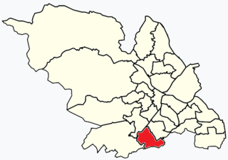
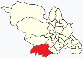
Shown within Sheffield
Population17,939 (2011)
District
Ceremonial county
Region
Country England
Sovereign state United Kingdom
EU Parliament Yorkshire and the Humber
UK Parliament
CouncillorsHelen Mirfin-Boukouris (Labour Party)
Christopher Rosling-Josephs (Labour Party)
Ian Saunders (Labour Party)
List of places
UK
England
Yorkshire

Beighton ward ( /ˈbtən, ˈb-/ ) [1] which includes the districts of Beighton, Hackenthorpe, Owlthorpe, and Sothallis one of the 28 electoral wards in City of Sheffield, England. It is located in the eastern part of the city, on the border with Rotherham and covers an area of 5.7 km2. The population of this ward in 2011 was 17,939 people in 7,538 households. [2]

Sheffield City and Metropolitan borough in England

Sheffield is a city and metropolitan borough in South Yorkshire, England. Historically part of the West Riding of Yorkshire, its name derives from the River Sheaf, which runs through the city. With some of its southern suburbs annexed from Derbyshire, the city has grown from its largely industrial roots to encompass a wider economic base. The population of the City of Sheffield is 577,800 (mid-2017 est.) and it is one of the eight largest regional English cities that make up the Core Cities Group. Sheffield is the third-largest English district by population. The metropolitan population of Sheffield is 1,569,000.

England Country in north-west Europe, part of the United Kingdom

England is a country that is part of the United Kingdom. It shares land borders with Wales to the west and Scotland to the north-northwest. The Irish Sea lies west of England and the Celtic Sea lies to the southwest. England is separated from continental Europe by the North Sea to the east and the English Channel to the south. The country covers five-eighths of the island of Great Britain, which lies in the North Atlantic, and includes over 100 smaller islands, such as the Isles of Scilly and the Isle of Wight.

Rotherham town in South Yorkshire, England

Rotherham is a town in South Yorkshire, England, which together with its conurbation and outlying settlements to the north, south and south-east forms the Metropolitan Borough of Rotherham, with a recorded population of 257,280 in the 2011 census. Historically in the West Riding of Yorkshire, its central area is on the banks of the River Don below its confluence with the Rother on the traditional road between Sheffield and Doncaster. Rotherham was well known as a coal mining town as well as a major contributor to the steel industry.

Contents

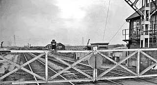
Before 1967, the districts of this ward formed part of Derbyshire. In that year an extension of the then County Borough of Sheffield took in the area, which was consequently transferred to the West Riding of Yorkshire. [3] In 1974 the area became part of the City of Sheffield, in the metropolitan and ceremonial county of South Yorkshire. [4]

Derbyshire ceremonial county in East Midlands, England

Derbyshire is a county in the East Midlands of England. A substantial portion of the Peak District National Park lies within Derbyshire, containing the southern extremity of the Pennine range of hills which extend into the north of the county. The county contains part of the National Forest, and borders on Greater Manchester to the northwest, West Yorkshire to the north, South Yorkshire to the northeast, Nottinghamshire to the east, Leicestershire to the southeast, Staffordshire to the west and southwest and Cheshire also to the west. Kinder Scout, at 636 metres (2,087 ft), is the highest point in the county, whilst Trent Meadows, where the River Trent leaves Derbyshire, is its lowest point at 27 metres (89 ft). The River Derwent is the county's longest river at 66 miles (106 km), and runs roughly north to south through the county. In 2003 the Ordnance Survey placed Church Flatts Farm at Coton in the Elms as the furthest point from the sea in Great Britain.

County borough is a term introduced in 1889 in the United Kingdom of Great Britain and Ireland, to refer to a borough or a city independent of county council control. They were abolished by the Local Government Act 1972 in England and Wales, but continue in use for lieutenancy and shrievalty in Northern Ireland. In the Republic of Ireland they remain in existence but have been renamed cities under the provisions of the Local Government Act 2001. The Local Government (Wales) Act 1994 re-introduced the term for certain "principal areas" in Wales. Scotland did not have county boroughs but instead counties of cities. These were abolished on 16 May 1975. All four Scottish cities of the time — Aberdeen, Dundee, Edinburgh, and Glasgow — were included in this category. There was an additional category of large burgh in the Scottish system, which were responsible for all services apart from police, education and fire.

West Riding of Yorkshire one of the historic subdivisions of Yorkshire, England

The West Riding of Yorkshire is one of the three historic subdivisions of Yorkshire, England. From 1889 to 1974 the administrative county, County of York, West Riding, was based closely on the historic boundaries. The lieutenancy at that time included the City of York and as such was named West Riding of the County of York and the County of the City of York.

Districts of Beighton ward

Looking down High Street of Beighton as it falls quite steeply from the area around the church into the bottom of the Rother Valley. Beighton.jpg
Looking down High Street of Beighton as it falls quite steeply from the area around the church into the bottom of the Rother Valley.

Beighton

Beighton (grid reference SK440835 ) is now a suburb of Sheffield after much expansion from a village in the last 100 years. The village was mentioned three times in the Domesday Book of 1086 as Bectun [5] the name meaning a farmstead beside a stream (or beck). Some remnants of the old village have survived including the church of Saint Mary the Virgin, which was built in the 12th century. The population in 1931 was 5,553.

Ordnance Survey National Grid System of geographic grid references used in Great Britain

The Ordnance Survey National Grid reference system is a system of geographic grid references used in Great Britain, distinct from latitude and longitude. It is often called British National Grid (BNG).

Suburb Human settlement that is part of or near to a larger city

A suburb is a mixed-use or residential area, existing either as part of a city or urban area or as a separate residential community within commuting distance of a city. In most English-speaking countries, suburban areas are defined in contrast to central or inner-city areas, but in Australian English and South African English, suburb has become largely synonymous with what is called a "neighborhood" in other countries and the term extends to inner-city areas. In some areas, such as Australia, India, China, New Zealand, the United Kingdom, and a few U.S. states, new suburbs are routinely annexed by adjacent cities. In others, such as Saudi Arabia, Canada, France, and much of the United States, many suburbs remain separate municipalities or are governed as part of a larger local government area such as a county.

Domesday Book 11th-century survey of landholding in England as well as the surviving manuscripts of the survey

Domesday Book is a manuscript record of the "Great Survey" of much of England and parts of Wales completed in 1086 by order of King William the Conqueror. The Anglo-Saxon Chronicle states:

Then, at the midwinter [1085], was the king in Gloucester with his council .... After this had the king a large meeting, and very deep consultation with his council, about this land; how it was occupied, and by what sort of men. Then sent he his men over all England into each shire; commissioning them to find out "How many hundreds of hides were in the shire, what land the king himself had, and what stock upon the land; or, what dues he ought to have by the year from the shire."

Being primarily a coal mining area, many of the houses erected in the first part of the 20th century were by the National Coal Board. Later expansion in the last 30 years has been in private housing.

Coal mining process of getting coal out of the ground

Coal mining is the process of extracting coal from the ground. Coal is valued for its energy content, and, since the 1880s, has been widely used to generate electricity. Steel and cement industries use coal as a fuel for extraction of iron from iron ore and for cement production. In the United Kingdom and South Africa, a coal mine and its structures are a colliery, a coal mine a pit, and the above-ground structures the pit head. In Australia, "colliery" generally refers to an underground coal mine. In the United States, "colliery" has been used to describe a coal mine operation but nowadays the word is not commonly used.

National Coal Board organization

The National Coal Board (NCB) was the statutory corporation created to run the nationalised coal mining industry in the United Kingdom. Set up under the Coal Industry Nationalisation Act 1946, it took over the United Kingdom's collieries on "vesting day", 1 January 1947. In 1987, the NCB was renamed the British Coal Corporation, and its assets were subsequently privatised.

The Rother Valley Country Park is just outside the eastern edge of the village and is a local centre for water sports. A number of artificial lakes have been created for this purpose.

Rother Valley Country Park

The Rother Valley Country Park is a country park in the Metropolitan Borough of Rotherham, South Yorkshire, close to Rotherham's border with Sheffield and Derbyshire. It covers 3 square kilometres, has four artificial lakes, recreational activities and nature reserves. The majority of the park is on the site of a former quarry, with the main excavation sites filled by the artificial lakes. There is still much of the original quarry machinery below the water.

Beighton railway station was on the Great Central Main Line.

Beighton railway station

Beighton railway station is a former railway station near the village of Beighton on the border between Derbyshire and South Yorkshire, England.

Great Central Main Line former railway line in the United Kingdom

The Great Central Main Line (GCML), also known as the London Extension of the Manchester, Sheffield and Lincolnshire Railway (MS&LR), is a former railway line in the United Kingdom. The line was opened in 1899 being built by the Great Central Railway running from Sheffield in the North of England, southwards through Nottingham and Leicester to Marylebone in London.

The parish church St. Mary the Virgin was restored in 1868 and a clock was erected in the tower in 1921 as a memorial to parishioners who gave their lives in the Great War.

Beighton Miners Welfare F.C. and Beighton Recreation F.C. both represented the area in the FA Cup

Sothall

grid reference SK440825 Sothall also includes the Meadowgate estate.

Brook House Junior School is the main junior school in Sothall, with 304 pupils. It serves from Year 3 to Year 6 (7-11 year olds). Beighton Nursery Infant School is the main nursery and the main infant school in the area. The nursery section serves 0-4 year olds and the infant school serves Reception to Year 2 (4-7 year olds).

Owlthorpe

grid reference SK418825

Owlthorpe [6] is a mainly residential area with the areas of Hackenthorpe, Birley and Waterthorpe. Sheffield Supertram circulates around the estate and can be easily accessed depending on your location at three tram stops: Birley Moor Road, Hackenthorpe or Donetsk Way. It was mostly rural until the late 1980s when major development was planned and followed through for the area.

Hackenthorpe

grid reference SK408838
Hackenthorpe is a village 5 miles south east of Sheffield’s city centre, now classed as a historic township of the city. Due to much expansion, the village became a part of Sheffield city during the 1950s. During much of the late 19th and 20th centuries the village was noted for its steelmaking, with the Thomas Staniforth & Co sickle works being based at Main Street. Another prominent feature of the village is the 17th century Hackenthorpe Hall, built by John Newbould for the Hounsfield family, with James Hounsfield being a prominent land owner. The building is today used as a nursery. [7] Hackenthope was once a part of Derbyshire in the parish of Beighton but is now part of South Yorkshire.

Related Research Articles

Ecclesall electoral ward of Sheffield City Council

Ecclesall Ward—which includes the neighbourhoods of Bents Green, Ecclesall, Greystones, Millhouses, and Ringinglow—is one of the 28 electoral wards in City of Sheffield, England. It is located in the southwestern part of the city and covers an area of 3.6 square miles. The population of this ward in 2007 was 19,211 people in 7,626 households, reducing to 6,657 at the 2011 Census. Ecclesall ward is one of the four wards that make up the South West Community Assembly and one of five wards that make up the Sheffield Hallam Parliamentary constituency. The Member of Parliament is Jared O'Mara, member of the Labour Party. Ecclesall is one of the least socially deprived wards in the entire country, with a 2002 deprivation score of 4.7—making it the 8,105th most deprived ward out of 8,414 wards in the country. The demographic consists largely of white, middle-class families.

Birley Spa

Birley Spa is a community bath hall and a Victorian bathhouse in the Hackenthorpe district of the City of Sheffield, England. It was built for Charles Herbert Pierrepont, 2nd Earl Manvers and the Lord of the Manor of Beighton in 1842, and initially was a hotel with spa baths beneath. Subsequently, it was used for many years as private dwellings. In the 1973 it was given Grade II listed building status.

Southey, South Yorkshire electoral ward of Sheffield City Council

Southey ward—which includes the districts of Fox Hill, New Parson Cross, Southey, Wadsley Bridge, and part of Old Parson Cross—is one of the 28 electoral wards in City of Sheffield, England. It is located in the northern part of the city and covers an area of 1.8 square miles. The population of this ward in 2011 was 19,086 people in 8,295 households. It is one of the wards that make up the Sheffield Brightside constituency.

Beauchief and Greenhill electoral ward of Sheffield City Council

Beauchief and Greenhill ward—which includes the districts of Batemoor, Beauchief, Chancet Wood, Greenhill, Jordanthorpe, and Lowedges—is one of the 28 electoral wards in City of Sheffield, England. It is located in the southern part of the city and covers an area of 2.4 square miles (6.2 km2). The population of this ward in 2011 was 18,815 people in 8,882 households.

Gleadless Valley (ward) electoral ward of Sheffield City Council

Gleadless Valley ward—which includes the districts of Gleadless Valley, Heeley, Lowfield, and Meersbrook—is one of the 28 electoral wards in City of Sheffield, England. It is located in the southern part of the city and covers an area of 4.5 km2. The population of this ward in 2011 was 21,089 people in 9,516 households. It is one of the five wards that form the Sheffield Heeley parliamentary constituency whose Member of Parliament elected at the 2001 general election was Meg Munn. Gleadless Valley actually describes the valley that separates Hemsworth from Herdings, and is a broad area that covers several housing estates: Hemsworth, Herdings and Rollestone. Gleadless Valley is bordered by Gleadless and Norton.

Dore and Totley electoral ward of Sheffield City Council

Dore and Totley ward—which includes the districts of Bradway , Dore, Totley, and Whirlow—is one of the 28 electoral wards in City of Sheffield, England. It is currently represented by three Liberal Democrat councillors. It is located in the southwestern part of the city and covers an area of 26.3 km2. The population of this ward in 2001 was 16,404 people in 7,037 households. Dore and Totley ward is one of the five wards that make up the Sheffield Hallam Parliamentary constituency. The population of Dore and Totley is 16,740 (2011) with 7,334 Households.

Hackenthorpe settlement in Sheffield, South Yorkshire, England

Hackenthorpe is a village 5 miles south east of Sheffield’s city centre, now classed as a historic township of the city. Due to much expansion, the village became a part of Sheffield city during the 1950s. During much of the late 19th and 20th centuries the village was noted for its steelmaking, with the Thomas Staniforth & Co Sickle works being based at Main Street. Another prominent feature of the village is the 17th century Hackenthorpe Hall, built by John Newbould for the Hounsfield family, with James Hounsfield being a prominent land owner. The building is today used as a nursery.

Graves Park (ward) electoral ward of Sheffield City Council

Graves Park ward—which includes the districts of Norton, Norton Lees, Norton Woodseats, and Woodseats—is one of the 28 electoral wards in City of Sheffield, England. It is located in the southern part of the city and covers an area of 5.8 km2. The population of this ward in 2011 was 16,705 people in 7,464 households. It is one of the five wards that form the Sheffield Heeley parliamentary constituency whose Member of Parliament elected at the 2001 general election was Meg Munn. The districts of this ward were in the historic county of Derbyshire, but they have now been absorbed into the metropolitan borough of Sheffield, thus placing them in the ceremonial county of South Yorkshire.

Birley electoral ward of Sheffield City Council

Birley ward — which includes the districts of Base Green, Birley Estate, Charnock, Frecheville, Scowerdons and part of Hackenthorpe — is one of the 28 electoral wards in City of Sheffield, England. It is located in the southeastern part of the city and covers an area of 5.1 km2. The population of this ward in 2011 was 16,943 people in 7,393 households. It is one of the five wards that make up the Sheffield Attercliffe constituency.

Areas of Sheffield

The areas of Sheffield, a city and metropolitan borough in the north of England, vary widely in size and history. Some of the areas developed from villages or hamlets, that were absorbed into Sheffield as the city grew, and thus their centres are well defined, but the boundaries of many areas are ambiguous. The areas of Sheffield do not play a significant administrative role, but the city is divided into 28 electoral wards for local elections and 6 parliamentary constituencies for national elections.

Burngreave (ward) Electoral ward in the City of Sheffield, England

Burngreave ward—which includes the districts of Burngreave, Fir Vale, Grimesthorpe, Pitsmoor, and Shirecliffe—is one of the 28 electoral wards in City of Sheffield, England. It is located in the northern part of the city and covers an area of 2.8 square miles. The population of this ward in 2011 was 27,481 people in 9,906 households. It is one of the wards that make up the Sheffield, Brightside and Hillsborough constituency. Most of the ward is served by a free community newspaper, the Burngreave Messenger.

Mosborough (ward) electoral ward of Sheffield City Council

Mosborough ward — which includes the districts of Halfway, Mosborough village, Waterthorpe, Westfield, as well as the rural area of Plumbley— is one of the 28 electoral wards in City of Sheffield, England. It is located in the eastern part of the city, on the border with Rotherham, and covers an area of 8.9 km2. The population of this ward in 2001 was 16,300 people in 7,000 households, the ward population increasing to 17,097 at the 2011 Census. It is one of the wards that make up the Sheffield South East constituency. The area is often referred to as Mosborough Townships. The population of the town increased to 17,097 in 2011 and is made up of 7,579 Households.

The Sheffield Coal Company was a colliery owning and coal selling company with its head office situated in South Street, Sheffield, South Yorkshire, England.

Shire Brook

Shire Brook is a small stream in the south eastern part of the City of Sheffield in South Yorkshire, England. It rises in the suburb of Gleadless Townend and flows in a general easterly direction for 4 miles (6.5 km) to its confluence with the River Rother between Beighton and Woodhouse Mill. In the past the brook has been both the border of Yorkshire and Derbyshire and between the sees of Canterbury and York. The course of the stream has been influenced by human intervention in the 20th century with the brook being diverted underground and flowing through culverts on three occasions as it traverses locations which were formerly landfill sites and extensive railway sidings.

Hackenthorpe Hall Listed building in Yorkshire, England

Hackenthorpe Hall is a 17th-century manor house located in Hackenthorpe, Sheffield, England. The building dates back to 1653, and was built by John Jermyn and his wife Alice Newbould, and was the historic residence of the Hounsfield family thereafter.

Birley Hay

Birley Hay is a hamlet in North East Derbyshire in the county of Derbyshire in England.

Hackenthorpe Cricket Club was a cricket club in Hackenthorpe, Sheffield, England. Although the team is now a local Yorkshire team, prior to Hackenthorpe being incorporated into Sheffield in the 1930s, the village and team was located in Derbyshire county.

Normanton Spring hamlet in Sheffield, South Yorkshire, England

Normanton Spring is a suburb and former hamlet located 4 miles east of Sheffield's City Centre, now classed as a historic township of the city. Due to expansion during the 1960s, the hamlet became a part of Sheffield City.

James Hounsfield

James Hounsfield was a British Squire, and landowner notable for rebuilding Hackenthorpe Hall.

References

  1. G.M. Miller, BBC Pronouncing Dictionary of British Names (Oxford UP, 1971), p. 13.
  2. "Key Figures for 2011 Census: Key Statistics – Area: Beighton (Ward)". Neighbourhood Statistics. Office for National Statistics. Retrieved 9 August 2016.
  3. Youngs, Frederic A., Jr (1991). Guide to the Local Administrative Units of England, Vol. II: Northern England. London: Royal Historical Society. p. 512. ISBN   0-11-750847-0.
  4. Local government in England and Wales: A Guide to the New System. London: HMSO. 1974. p. 21. ISBN   0-11-750847-0.
  5. Domesday Book: A Complete Translation. London: Penguin, 2003. ISBN   0-14-143994-7 p.1313
  6. Owlsthorpe is spelt Dwestorp in Domesday where is it briefly mentioned in a list of manors belonging, in Yorkshire, to the Bishop of Durham
  7. http://www.picturesheffield.com/frontend.php?keywords=Ref_No_increment;EQUALS;s05325&pos=1&action=zoom&id=8737

Coordinates: 53°21′N01°13′W / 53.350°N 1.217°W / 53.350; -1.217