The Georges Head Battery, also called the Georges Head Military Fortifications, is a heritage-listed former military fortification located on the Georges Head on Chowder Bay Road, Georges Heights, New South Wales, Australia.

The Detached Mole is a breakwater located at the western aspect of the middle section of Gibraltar Harbour, in the British Overseas Territory of Gibraltar, at the southern end of the Iberian Peninsula. The Detached Mole, with the rest of harbour, is just north of the east entrance to the Strait of Gibraltar and was the site of the Detached Mole Battery. In addition to the role the breakwater plays in the defence of and access to the harbour, the Detached Mole provides berths for ships. The area adjacent to the mole is also a source of recreational and research opportunities, with dive sites at the wrecks of sunken ships.

The North Mole is a breakwater located in the northern section of Gibraltar Harbour, in the British Overseas Territory of Gibraltar, at the southern end of the Iberian Peninsula. The North Mole, with the rest of harbour, is just north of the east entrance to the Strait of Gibraltar. The breakwater was formerly known as the Commercial Mole, and is the site of the commercial port in the harbour. It was the consequence of a late nineteenth century plan by the British Admiralty to create a modern dockyard and large defensive harbour in Gibraltar.

Parson's Lodge Battery is a coastal battery and fort in the British Overseas Territory of Gibraltar.

Rosia Bay is the only natural harbour in Gibraltar, the British Overseas Territory at the southern end of the Iberian Peninsula. Formerly referred to as Rosia Harbour, it is located on the southwest side of Gibraltar. Rosia Bay was the site of the Royal Navy Victualling Yard complex which was constructed in the early 19th century, allowing vessels to anchor and obtain provisions, including food and water. Vice Admiral Horatio Nelson obtained supplies for his Mediterranean Fleet at Rosia Bay. It was to that same anchorage that his vessel HMS Victory was towed after Nelson's death in the 1805 Battle of Trafalgar. The area is also the location of gun batteries, including Parson's Lodge Battery at the south end of the bay and Napier of Magdala Battery at the north end. In the 21st century, Rosia Bay was the focus of controversy following the government's demolition of the historic Rosia Water Tanks and construction of the affordable housing development Nelson's View, which necessitated the relocation of the owners of the adjacent 19th century Rosia Cottages.
The Line Wall Curtain is a defensive curtain wall that forms part of the fortifications of the British Overseas Territory of Gibraltar.

The Victualling Yard was a victualling facility in the British Overseas Territory of Gibraltar built for supplying Royal Navy ships while anchored at Rosia Bay.

Flat Bastion is a bastion which projects southward from the Charles V Wall in the British Overseas Territory of Gibraltar. Once known as the St. Jago's Bastion or the Baluarte de Santiago in Spanish, the fortification was built by the Spanish in the mid 16th century and formed part of the southern defences of the city of Gibraltar, together with Charles V Wall, Southport Gates, Southport Ditch, and South Bastion. In 1859, six guns, four 12-pounders and two 12-pound carronades, were installed on the bastion, and four years later, five 32-pounders were mounted on the fortification.
Devil's Gap Battery is a coastal battery in the British Overseas Territory of Gibraltar, overlooking the Bay of Gibraltar near the westernmost limits of the Upper Rock Nature Reserve.

The North Bastion, formerly the Baluarte San Pablo was part of the fortifications of Gibraltar, in the north of the peninsula, protecting the town against attack from the mainland of Spain. The bastion was based on the older Giralda tower, built in 1309. The bastion, with a mole that extended into the Bay of Gibraltar to the west and a curtain wall stretching to the Rock of Gibraltar on its east, was a key element in the defenses of the peninsula. After the British took Gibraltar in 1704 they further strengthened these fortifications, flooding the land in front and turning the curtain wall into the Grand Battery.

Green's Lodge Battery is an artillery battery in the British Overseas Territory of Gibraltar. It is located on the North Face of the Rock of Gibraltar at the northern end of the Upper Rock Nature Reserve, above Farringdon's Battery. Also known as the Superior Battery, it was named after General Sir William Green, who served in Gibraltar for twenty-two years, most of them as the chief engineer of Gibraltar. In 1776, guns were first mounted on the battery, which also saw action during the Great Siege of Gibraltar. The emplacement also underwent reconstruction in the early and mid twentieth century. Green's Lodge Battery is listed with the Gibraltar Heritage Trust.

King's Bastion is a coastal bastion on the western front of the fortifications of the British overseas territory of Gibraltar, protruding from the Line Wall Curtain. It is located between Line Wall Road and Queensway and overlooks the Bay of Gibraltar. It played a crucial role in defending The Rock during the Great Siege of Gibraltar. In more recent history the bastion was converted into a generating station which powered Gibraltar's electricity needs. Today it continues to serve the community as Gibraltar's leisure centre.

Buena Vista Battery was an artillery battery near the Buena Vista Barracks at the southern end of the British Overseas Territory of Gibraltar. It is located on a slight ridge in front of the nearby Buena Vista Barracks, which was once the base of the Royal Gibraltar Regiment.

Couvreport Battery is an artillery battery in the British Overseas Territory of Gibraltar.

Hanover Battery was an artillery battery on the north west part of the British Overseas Territory of Gibraltar. The battery is casemated. Beneath the battery was a tunnel known as Hanover Gallery.

King's Lines Battery is an artillery battery in the British Overseas Territory of Gibraltar. It was originally built along the access path up to the Gate of Granada.
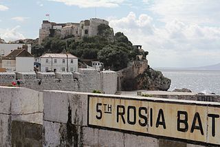
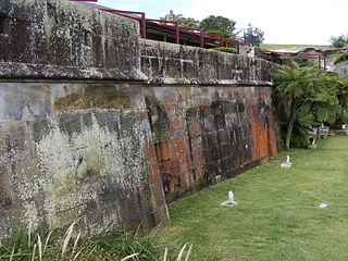
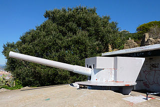
The Rosia Batteries are a group of artillery batteries in the British Overseas Territory of Gibraltar.

The Gibraltar peninsula, located at the far southern end of Iberia, has great strategic importance as a result of its position by the Strait of Gibraltar where the Mediterranean Sea meets the Atlantic Ocean. It has repeatedly been contested between European and North African powers and has endured fourteen sieges since it was first settled in the 11th century. The peninsula's occupants – Moors, Spanish, and British – have built successive layers of fortifications and defences including walls, bastions, casemates, gun batteries, magazines, tunnels and galleries. At their peak in 1865, the fortifications housed around 681 guns mounted in 110 batteries and positions, guarding all land and sea approaches to Gibraltar. The fortifications continued to be in military use until as late as the 1970s and by the time tunnelling ceased in the late 1960s, over 34 miles (55 km) of galleries had been dug in an area of only 2.6 square miles (6.7 km2).

The Great North Road is a large road tunnel in the British Overseas Territory of Gibraltar. It was constructed by the British military during World War II inside the Rock of Gibraltar and remains property of the Ministry of Defence to this day. The road allowed lorries to travel from the north to the south of Gibraltar entirely within the Rock. The tunnel still contains the remains of World War II buildings such as Nissen huts, kitchens, offices as well as a generating station and period anti-submarine nets.

The Lines of Contravallation of Gibraltar, known in English as the "Spanish Lines", were a set of fortifications built by the Spanish across the northern part of the isthmus linking Spain with Gibraltar. They later gave their name to the Spanish town of La Línea de la Concepción. The Lines were constructed after 1730 to establish a defensive barrier across the peninsula, with the aim of preventing any British incursions, and to serve as a base for fresh Spanish attempts to retake Gibraltar. They played an important role in the Great Siege of Gibraltar between 1779 and 1783 when they supported the unsuccessful French and Spanish assault on the British-held fortress. The siege was ended after the lines of contravallation were attacked by British and Dutch forces under the command of the Governor of Gibraltar, General Augustus Eliot. The attack caused the Spanish forces to retreat and abandon the fortifications and the combined British led forces virtually destroyed all the Spanish gun batteries and the enemy cannon and munitions either captured or destroyed. This attack is still commemorated to this day and is known as 'Sortie Day'.


