Mechanicsville is an unincorporated community and census-designated place (CDP) in Hanover County, Virginia, United States. The population was 39,482 during the 2020 census, up from 36,348 in the 2010 census.

Bull Run is a census-designated place (CDP) in Prince William County, Virginia. The population was 14,983 at the 2010 census.

Falmouth is a census-designated place (CDP) in Stafford County, Virginia, United States. Situated on the north bank of the Rappahannock River at the falls, the community is north of and opposite the city of Fredericksburg. Recognized by the U.S. Census Bureau as a census-designated place (CDP), Falmouth's population was 4,956 as of the 2020 census.

Brandy Station is an unincorporated community and census-designated place (CDP) in Culpeper County, Virginia, United States. It was first listed as a CDP in the 2020 census with a population of 191. Its original name was Brandy. The name Brandy Station comes from a local tavern sign that advertised brandy.
Heathsville is a census-designated place (CDP) in and the county seat of Northumberland County, Virginia, United States. Heathsville is in the easternmost county of the Northern Neck of Virginia, which was the birthplace of three of the first five Presidents of the United States - George Washington, James Madison, and James Monroe. It is the county seat of Northumberland County, and has housed four county courthouses since the first was built in 1663.

Aldie is an unincorporated community and census-designated place (CDP) located between Chantilly and Middleburg in Loudoun County, Virginia, United States. The historic village of Aldie is located on the John Mosby Highway in a gap between the Catoctin Mountains and Bull Run Mountains, through which the Little River flows. Aldie traditionally serves as the gateway to the Loudoun Valley and beyond.
Falling Waters is a census-designated place (CDP) on the Potomac River in Berkeley County, West Virginia, United States. It is located along Williamsport Pike north of Martinsburg. An 1887 Scientific American article claimed that the first U.S. railroad was built in Falling Waters in 1814.

Meadows of Dan is an unincorporated community and census-designated place in Patrick County, Virginia, where the Blue Ridge Parkway crosses U.S. Route 58. It was first listed as a CDP in the 2020 census with a population of 72.

Hanover is an unincorporated community and census-designated place (CDP) in Hanover County, Virginia, United States. It is the county seat and is located at the junction of U.S. Route 301 and State Route 54 south of the Pamunkey River. While historically known as Hanover Courthouse, the U.S. Geological Survey, Census Bureau, Postal Service and residents refer to it as "Hanover". The population as of the 2010 census was 252.

Johnsonburg is an unincorporated community and census-designated place (CDP) located within Frelinghuysen Township in Warren County, in the U.S. state of New Jersey, that was created as part of the 2010 United States Census. As of the 2020 Census, the CDP's population was 381, up from 101 in the 2010 Census.

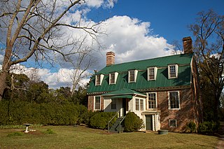
King William is a census-designated place (CDP) in and the county seat of King William County, Virginia, United States. The population as of the 2010 census was 252. Located in King William is the oldest courthouse in continuous use in the United States, built in 1725. The community is also known as King William Courthouse or, by an alternative spelling, King William Court House.

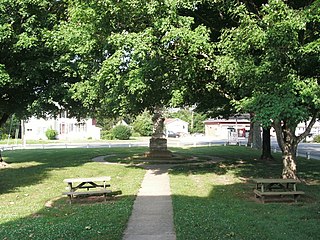
Lancaster is an unincorporated community and census-designated place (CDP) in Lancaster County, Virginia, United States. It is the county seat, and is also known as Lancaster Courthouse or by an alternative spelling, Lancaster Court House. The community was first drawn as a CDP prior to the 2020 census and had a population of 105 at the said census.
Beech Island is an unincorporated community and census-designated place (CDP) in Aiken County, South Carolina, United States. It was first listed as a CDP in the 2020 census with a population of 1,421.

Brookside is a historic unincorporated community and census-designated place (CDP) located within Mendham Township in Morris County, in the U.S. state of New Jersey. It is located approximately 6 mi (9.7 km) west of Morristown, the county seat.

Sanford is a census-designated place (CDP) in Accomack County, Virginia, United States. It was first listed as a CDP in 2010. Per the 2020 census, the population was 168.

Franktown is an unincorporated community and census-designated place in Northampton County, Virginia, United States. It was first listed as a CDP in the 2020 census with a population of 61.
Founded in 1886, Weems is an unincorporated community and census-designated place (CDP) in Lancaster County in the U. S. state of Virginia. It was first drawn as a CDP prior to the 2020 census.

Croom is an unincorporated community and census-designated place in Southern Prince George's County, Maryland, United States. As of the 2020 census it had a population of 2,720. Croom largely consists of former tobacco farms and forests converted to Washington bedroom subdivisions such as nearby Marlton. The main part of Patuxent River Park is in Croom.

New Edinburg is an unincorporated census-designated place in Cleveland County, Arkansas, United States. Per the 2020 census, the population was 134.
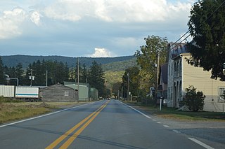
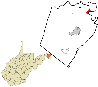
Bartow is a census-designated place (CDP) in Pocahontas County, West Virginia, United States. The population was 111 at the 2010 census.


