Egger Highlands, San Diego | |
---|---|
Egger Highlands | |
Coordinates: 32°35′14″N117°05′47″W / 32.587103°N 117.096278°W | |
Country | United States of America |
State | California |
County | San Diego |
City | San Diego |
Named for | Robert Egger Sr. |
Elevation | 2 m (7 ft) |
Population (2020) | |
• Total | 12,102 |
ZIP code | 92154 |
Area code | 619 |
Egger Highlands is a residential neighborhood in the southern section of San Diego. It neighbors Palm City and Nestor to the east, San Diego Bay to the north, Imperial Beach to the southwest and Chula Vista to the northeast. Major thoroughfares include Coronado Avenue, Saturn Boulevard, and Palm Avenue.
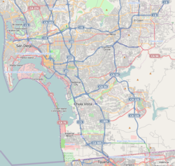
Egger Highlands is named for the Egger family, which donated land in 1946 to house St. Charles Catholic Church, the area's first Roman Catholic church. [1] Egger Highlands, along with other portions of South San Diego, was annexed by the city of San Diego from San Diego County in 1957. [2] In 1993, The murders of Jonathan Sellers and Charlie Keever were believed to have occurred on the Otay River Valley Bike Trail behind the Southland Shopping Center. [3]
Egger Highlands is home to the Robert Egger, Sr. Community Park, located at Coronado Avenue and Saturn Boulevard.
Private schools in Egger Highlands include the St. Charles School. [4] The area is served by Sweetwater Union High School District and it currently houses just one Middle School which includes Mar Vista Academy.
San Ysidro is a district of the City of San Diego, immediately north of the Mexico–United States border. It neighbors Otay Mesa West to the north, Otay Mesa to the east, and Nestor and the Tijuana River Valley to the west; together these communities form South San Diego, a practical exclave of the City of San Diego. Major thoroughfares include Beyer Boulevard and San Ysidro Boulevard.
Mar Vista is a neighborhood on the Westside of Los Angeles, California. In 1927, Mar Vista became the 70th community to be annexed to Los Angeles. It was designated as an official city neighborhood in 2006.
Linda Vista is a community in San Diego, California, United States. Located east of Mission Bay, north of Mission Valley, and south-east of Tecolote Canyon, it lies on a mesa overlooking Mission Valley to the south and Mission Bay and the Pacific Ocean to the west. It is also home to the University of San Diego.
State Route 75 (SR 75) is a 13-mile (21 km) north-south state highway in San Diego County in the U.S. state of California. It is a loop route of Interstate 5 (I-5) that begins near Imperial Beach, heading west on Palm Avenue. The route continues north along the Silver Strand, a thin strip of land between the Pacific Ocean and San Diego Bay, through Silver Strand State Beach. SR 75 then passes through the city of Coronado as Orange Avenue and continues onto the San Diego–Coronado Bay Bridge, which traverses the bay, before joining back with I-5 near downtown San Diego.
City Heights is a dense urban community in central San Diego, California, known for its ethnic diversity. The area was previously known as East San Diego. City Heights is located south of Mission Valley and northeast of Balboa Park.
Normal Heights is a neighborhood of the mid-city region of San Diego, California.
Paradise Hills is an urban neighborhood in the southeastern area of the city of San Diego, California. It is an outlying neighborhood adjacent to the independent city of National City and the unincorporated communities of Lincoln Acres and certain portions of Bonita. The neighborhood is part of the Skyline-Paradise Hills Community Planning Area.
Clairemont is a community within the city of San Diego, California, United States. It has a population of about 81,600 residents and an area of roughly 13.3 square miles (34 km2). Clairemont Mesa is bordered by Interstate 805 on the east, Interstate 5 to the west, State Route 52 to the north, and the community of Linda Vista to the south. The community of Clairemont Mesa can be subdivided into the neighborhoods of North Clairemont, Clairemont Mesa East, Clairemont Mesa West, Bay Park, and Bay Ho.
South San Diego is a district within the City of San Diego, and is in the larger South Bay region of southwestern San Diego County, California. South San Diego is a practical exclave of San Diego, having no land connection with the rest of the city. It is the only part of the city which borders Mexico. South San Diego includes four of the city's official community planning areas: Otay Mesa, Otay Mesa-Nestor, San Ysidro, and the Tijuana River Valley.
Rolando is a neighborhood of the Mid-City region of San Diego, California. Rolando is mostly residential with the exception of El Cajon Boulevard, which features the Campus Plaza shopping center. Rolando is divided by University Avenue into two sections: Rolando Village to the north, and Rolando Park to the south.
Cortez Hill is a neighborhood located in the northeast part of Downtown San Diego, California.
Mater Dei Catholic (MDCHS) is a private, Roman Catholic TK-12 school in Chula Vista, California, United States. It is located in the Roman Catholic Diocese of San Diego.
Roseville-Fleetridge is a neighborhood in Point Loma, San Diego, California. It is bounded by San Diego Bay and Rosecrans Street on the east, Cañon Street on the south, Catalina Boulevard on the west and Chatsworth and Nimitz Boulevards on the north. Neighboring communities are Point Loma Heights and Loma Portal to the north, Point Loma Village and Liberty Station to the east, La Playa and the Wooded Area to the south, and Sunset Cliffs to the west. It is actually two separate neighborhoods, Roseville and Fleetridge, which the city lumps together for policing purposes.
Nestor is a residential neighborhood in the southern section of San Diego, and part of the Otay Mesa-Nestor community planning area. It neighbors Palm City and Otay Mesa West to the east, Egger Highlands to the north, San Ysidro to the southeast and the Tijuana River Valley to the south. Major thoroughfares include Coronado Avenue, Saturn Boulevard, Hollister Street, and Tocayo Avenue.
Palm City is a neighborhood in the southern section of San Diego. Its neighbors are Otay Mesa West to the south and east, Egger Highlands and Nestor to the west, and Chula Vista to the north. It also serves as a gateway to the beach cities of Imperial Beach, and Coronado, by way of the Silver Strand isthmus, due to it being where California State Route 75 meets Interstate 5. Major thoroughfares include Coronado Avenue, Hollister Street, Beyer Boulevard, and Palm Avenue.
Otay Mesa West is a residential neighborhood in the southern section of San Diego. It borders Interstate 805 to the east, Interstate 5 to the west, and California State Route 905 to the south. It neighbors Ocean View Hills to the east, Nestor and Palm City to the west and Chula Vista to the north. The northern boundary of Otay Mesa West roughly coincides with the Otay River. Just north of the Otay River the community of Otay resides within the city of Chula Vista. Major thoroughfares include Palm Avenue, Coronado Avenue, Picador Boulevard, Del Sol Boulevard, Beyer Boulevard, and Beyer Way.
Mountain View is an urban community in the southeastern section of the city of San Diego. It is bordered by Mount Hope and Greenwood Memorial Park on the north, Interstate 15 and the neighborhoods of Stockton and Logan Heights on the west, Interstate 805 and Lincoln Park on the east, and Southcrest and National City on the south. Major thoroughfares include Imperial Avenue and Ocean View Boulevard.
Valencia Park is an urban community in the southeastern section of the city of San Diego, California, United States. It is bordered by Emerald Hills and Market Street on the north, Lincoln Park and Euclid Avenue on the west, Encanto on the east, and Alta Vista and National City, California on the south. Major thoroughfares include Imperial Avenue, Churchward Street, and Valencia Parkway.
Point Loma Heights is a neighborhood in Point Loma, San Diego, California. It is bounded by Froude Street on the west, Point Loma Avenue and Chatsworth Boulevard on the south, Nimitz Boulevard on the east and Midway Drive and the San Diego River on the north. Neighboring communities are Ocean Beach to the west, Sunset Cliffs and Roseville-Fleetridge to the south, Loma Portal to the east, and Midway and Mission Bay Park to the north.