Fairport Harbor, Ohio

Last updated

Fairport Harbor, Ohio
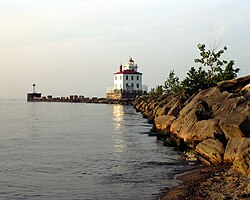
Fairport Harbor West Breakwater Light.jpg
Fairport Harbor West Breakwater Light viewed from the Headlands Dunes State Nature Preserve
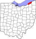
OHMap-doton-Fairport Harbor.png
Location of Fairport Harbor, Ohio
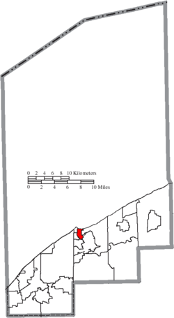
Map of Lake County Ohio Highlighting Fairport Harbor Village.png
Location of Fairport Harbor in Lake County
Coordinates: 41°44′52″N81°16′23″W / 41.74778°N 81.27306°W / 41.74778; -81.27306
Country United States
State Ohio
County Lake
Township Painesville
Government
  Type Mayor–council
  MayorTimothy Manross (D) [1]
Area
[2]
  Total1.11 sq mi (2.87 km2)
  Land1.03 sq mi (2.66 km2)
  Water0.08 sq mi (0.21 km2)
Elevation
[3]
610 ft (190 m)
Population
 (2020)
  Total3,108
  Estimate 
(2023) [4]
3,081
  Density3,026.29/sq mi (1,168.37/km2)
Time zone UTC-5 (Eastern (EST))
  Summer (DST) UTC-4 (EDT)
ZIP code
44077
Area code 440
FIPS code 39-26306 [5]
GNIS feature ID2398857 [3]
Website www.fairportharbor.org

Fairport Harbor is a village in Lake County, Ohio, United States, along Lake Erie at the mouth of the Grand River. The population was 3,108 at the 2020 census. A far-eastern suburb of Cleveland, it is part of the Cleveland metropolitan area.

Contents

Fairport Harbor is home to two lighthouses: the Fairport Harbor West Breakwater Light in Painesville Township, operated by the United States Coast Guard and the Grand River (Fairport Harbor) Light operated by the Fairport Harbor Historical Society. It is also the home of the Finnish Heritage Museum.

History

Fairport Harbor's location at the mouth of the Grand River made it an ideal place for a settlement. After being claimed as part of the Connecticut Western Reserve by the Connecticut Land Company in 17961797, the town of Grandon was platted there on May 16, 1812. When the town incorporated in 1836, the name was changed to "Fairport." [6] Fairport is a commendatory name. [7] The current name was adopted in 1959. [8]

After receiving federal sponsorship, the village's port flourished, and an influx of Finns, Hungarians, and Slovaks arrived there. The port also imported iron ore for use at area steel mills. The port continues operation at a more limited capacity. [6]

Later in the village's history, the Diamond Alkali Company operated from 1912 to 1976. [6]

In recent years Fairport Harbor has hosted the Lake County Perch Fest [9] [10] and opened the Finnish Heritage Museum.

On January 24, 2011, an overpressurized Dominion East Ohio natural gas pipeline caused devices in at least 17 dwellings to explode, causing the structures to burn and leading to a mass evacuation. [11] [12] The excess pressure has been attributed to ice present in a sensor line causing a false reading in a pressure regulator. [13] The backup regulator for the pipeline also failed. [14] While no injuries were reported in the community, [12] [15] the cost of damage was placed at approximately $1.2 million. [16]

Geography

Fairport Harbor is located within Painesville Township. [17]

According to the United States Census Bureau, the village has a total area of 1.11 square miles (2.87 km2), of which 1.03 square miles (2.67 km2) are land and 0.08 square miles (0.21 km2) are water. [18]

Demographics

Hungarian Reformed Church in Fairport Harbor Hungarian Reformed Church Fairport Harbor.jpg
Hungarian Reformed Church in Fairport Harbor
Historical population
CensusPop.Note
1880 296
1890 1,171295.6%
1900 2,07377.0%
1910 2,2639.2%
1920 4,21186.1%
1930 4,97218.1%
1940 4,528−8.9%
1950 4,519−0.2%
1960 4,267−5.6%
1970 3,665−14.1%
1980 3,357−8.4%
1990 2,978−11.3%
2000 3,1806.8%
2010 3,109−2.2%
2020 3,1080.0%
2023 (est.)3,081 [4] −0.9%
U.S. Decennial Census [19] [20]

2010 census

As of the census [21] of 2010, there were 3,109 people, 1,427 households, and 764 families living in the village. The population density was 3,018.4 inhabitants per square mile (1,165.4/km2). There were 1,677 housing units at an average density of 1,628.2 per square mile (628.7/km2). The racial makeup of the village was 94.7% White, 2.1% African American, 0.2% Native American, 0.3% Asian, 0.6% from other races, and 2.1% from two or more races. Hispanic or Latino of any race were 2.2% of the population.

There were 1,427 households, of which 25.1% had children under the age of 18 living with them, 35.8% were married couples living together, 13.0% had a female householder with no husband present, 4.8% had a male householder with no wife present, and 46.5% were non-families. 38.6% of all households were made up of individuals, and 12.4% had someone living alone who was 65 years of age or older. The average household size was 2.17 and the average family size was 2.90.

The median age in the village was 41 years. 20.7% of residents were under the age of 18; 9% were between the ages of 18 and 24; 25.7% were from 25 to 44; 29.8% were from 45 to 64; and 14.8% were 65 years of age or older. The gender makeup of the village was 48.6% male and 51.4% female.

2000 census

As of the census [5] of 2000, there were 3,180 people, 1,404 households, and 839 families living in the village. The population density was 3,052.2 inhabitants per square mile (1,178.5/km2). There were 1,546 housing units at an average density of 1,483.8 per square mile (572.9/km2). The racial makeup of the village was 97.96% White, 0.57% African American, 0.09% Native American, 0.16% Asian, 0.03% Pacific Islander, 0.13% from other races, and 1.07% from two or more races. Hispanic or Latino of any race were 1.38% of the population. 15.9% were of German, 12.3% Finnish, 11.5% Hungarian, 11.2% Irish, 9.3% Italian and 5.2% English ancestry according to Census 2000. 95.5% spoke English, 2.4% Finnish and 2.1% Hungarian as their first language.

There were 1,404 households, out of which 26.9% had children under the age of 18 living with them, 41.6% were married couples living together, 12.3% had a female householder with no husband present, and 40.2% were non-families. 34.3% of all households were made up of individuals, and 11.1% had someone living alone who was 65 years of age or older. The average household size was 2.26 and the average family size was 2.90.

In the village, the population was spread out, with 23.0% under the age of 18, 8.8% from 18 to 24, 31.4% from 25 to 44, 22.1% from 45 to 64, and 14.7% who were 65 years of age or older. The median age was 37 years. For every 100 females there were 98.0 males. For every 100 females age 18 and over, there were 95.2 males.

The median income for a household in the village was $35,205, and the median income for a family was $45,142. Males had a median income of $31,971 versus $24,657 for females. The per capita income for the village was $20,722. About 5.9% of families and 7.4% of the population were below the poverty line, including 7.8% of those under age 18 and 6.6% of those age 65 or over. [22]
Related Research Articles

<span class="mw-page-title-main">Jonesville, Michigan</span> City in Michigan, United States

Jonesville is a city in Hillsdale County in the U.S. state of Michigan. The population was 2,176 at the 2020 census.

<span class="mw-page-title-main">Aberdeen, Ohio</span> Village in Ohio, United States

Aberdeen is a village in Huntington Township, Brown County, Ohio, United States, along the Ohio River 50 miles (80 km) southeast of Cincinnati. The population was 1,515 at the 2020 census.

<span class="mw-page-title-main">Yorkshire, Ohio</span> Village in Ohio, United States

Yorkshire is a village in Darke County, Ohio, United States. The population was 95 at the 2020 census.

<span class="mw-page-title-main">Baltimore, Ohio</span> Village in Ohio, United States

Baltimore is a village in Fairfield County, Ohio, United States. The population was 2,981 at the 2020 census.

<span class="mw-page-title-main">Bremen, Ohio</span> Village in Ohio, United States

Bremen is a village in Fairfield County, Ohio, United States. The population was 1,479 at the 2020 census.

<span class="mw-page-title-main">Riverlea, Ohio</span> Village in Ohio, United States

Riverlea is a village in Franklin County, Ohio, United States, surrounded by Worthington on its north, south, and east sides, and bordered on the west by the Olentangy River, across which is Columbus. Riverlea was incorporated in 1939, a small community that formed on former farmland. The population was 599 at the 2020 census.

<span class="mw-page-title-main">Vinton, Ohio</span> Village in Ohio, United States

Vinton is a village in Gallia County, Ohio, United States. The population was 224 at the 2020 census. It is part of the rural Point Pleasant micropolitan area.

<span class="mw-page-title-main">Addyston, Ohio</span> Village in Ohio, United States

Addyston is a village in Miami Township, Hamilton County, Ohio, United States. Located along the Ohio River, it is a western suburb of the neighboring city of Cincinnati. The population was 927 at the 2020 census.

<span class="mw-page-title-main">Newtown, Ohio</span> Village in Ohio, United States

Newtown is a village in southeastern Hamilton County, Ohio, United States, near Cincinnati. The population was 2,702 at the 2020 census. Newtown was settled in 1792 and incorporated as a village in 1901.

<span class="mw-page-title-main">Harbor Hills, Ohio</span> Census-designated place in Ohio, United States

Harbor Hills is a census-designated place (CDP) in southern Licking County, Ohio, United States. The population was 1,565 at the 2020 census.

<span class="mw-page-title-main">Harbor View, Ohio</span> Village in Ohio, United States

Harbor View is a village in Lucas County, Ohio, United States. The population was 89 at the 2020 census.

<span class="mw-page-title-main">Clarington, Ohio</span> Village in Ohio, United States

Clarington is a village in Monroe County, Ohio, United States, along the Ohio River. The population was 280 at the 2020 census.

<span class="mw-page-title-main">Shiloh, Richland County, Ohio</span> Village in Ohio, United States

Shiloh is a village in Richland County in the U.S. state of Ohio. It is part of the Mansfield, Ohio Metropolitan Statistical Area. The population was 619 at the 2020 census.

<span class="mw-page-title-main">Port Jefferson, Ohio</span> Village in Ohio, United States

Port Jefferson is a village in Salem Township, Shelby County, Ohio, United States. The population was 308 at the 2020 census.

<span class="mw-page-title-main">McArthur, Ohio</span> Village in Ohio, United States

McArthur is a village in and the county seat of Vinton County, Ohio, United States. It is located 27 miles (43 km) southeast of Chillicothe. The population was 1,783 at the 2020 census.

<span class="mw-page-title-main">Lower Salem, Ohio</span> Village in Ohio, United States

Lower Salem is a village in Washington County, Ohio, United States. The population was 75 at the 2020 census.

<span class="mw-page-title-main">Macksburg, Ohio</span> Village in Ohio, United States

Macksburg is a village in Washington County, Ohio, United States, along the West Fork of Duck Creek. The population was 120 at the 2020 census. The village is about 28 miles (45 km) south of Cambridge, Ohio.

<span class="mw-page-title-main">Yorkville, Ohio</span> Village in Ohio, United States

Yorkville is a village in Belmont and Jefferson counties in the U.S. state of Ohio. The population was 968 at the 2020 census. Yorkville lies within two Metropolitan Statistical Areas; the Belmont County portion is part of the Wheeling metropolitan area, while the Jefferson County portion is part of the Weirton–Steubenville metropolitan area.

<span class="mw-page-title-main">Gratiot, Ohio</span> Village in Ohio, United States

Gratiot is a village in Licking and Muskingum counties in the U.S. state of Ohio. The population was 215 at the 2020 census.

<span class="mw-page-title-main">Egg Harbor, Wisconsin</span> Village in Wisconsin, United States

Egg Harbor is a village in Door County, Wisconsin, United States. The population was 201 at the 2010 census. The village was incorporated in 1964, and is adjacent to the Town of Egg Harbor and the Town of Gibraltar.

References

  1. "Elected Officials" (PDF). Retrieved August 1, 2024.
  2. "ArcGIS REST Services Directory". United States Census Bureau. Retrieved September 20, 2022.
  3. 1 2 U.S. Geological Survey Geographic Names Information System: Fairport Harbor, Ohio
  4. 1 2 "Annual Estimates of the Resident Population for Incorporated Places in Ohio: April 1, 2020 to July 1, 2023". United States Census Bureau. Retrieved June 24, 2024.
  5. 1 2 "U.S. Census website". United States Census Bureau . Retrieved January 31, 2008.
  6. 1 2 3 History of Fairport Harbor Village of Fairport Harbor website. Retrieved on August 16, 2019.
  7. Overman, William Daniel (1958). Ohio Town Names. Akron, OH: Atlantic Press. p. 44.
  8. Fertal, Caitlin (May 12, 2012). "Fairport Harbor Marks 200th Birthday". The News-Herald . Retrieved May 13, 2012.
  9. Lake County Perch Fest website. Retrieved on April 26, 2011.
  10. Frischkorn, Jeffery L. (May 22, 2012). "Lake County Visitors Bureau Ends PerchFest". The News-Herald. Retrieved May 23, 2012.
  11. Carrabine, Nick (January 24, 2011). "Officials say high gas pressure led to multiple fires in Fairport Harbor". The News-Herald. Retrieved January 26, 2011.
  12. 1 2 "Natural gas blast, fires disrupt life in Ohio town". Associated Press. January 24, 2011. Retrieved January 26, 2011.[ dead link ]
  13. Carrabine, Nick; Caitlin Fertal (January 26, 2011). "Investigators going door to door in Fairport Harbor checking gas lines". The News-Herald . Retrieved January 26, 2011.
  14. Funk, John (January 25, 2011). "Fairport Harbor fires prompt investigation of Dominion East Ohio pipeline safety equipment". The Plain Dealer . Retrieved February 3, 2011.
  15. Garrett, Amanda (February 6, 2011). "A small town, a gas surge and chaos: This is the story of what happened in Fairport Harbor" . The Plain Dealer. Retrieved June 15, 2024. Article excerpt
  16. Funk, John (February 23, 2011). "Fairport Harbor damages estimated at $1.2 million in gas explosions". The Plain Dealer. Retrieved February 26, 2011.
  17. Detailed Census Bureau map
  18. "U.S. Gazetteer Files: 2019: Places: Ohio". U.S. Census Bureau Geography Division. Retrieved July 1, 2020.
  19. "Census of Population and Housing". Census.gov. Retrieved June 4, 2015.
  20. "Total Population: 2010 Census DEC Summary File 1 (P1), Fairport Harbor village, Ohio". data.census.gov. U.S. Census Bureau. Retrieved July 1, 2020.
  21. "U.S. Census website". United States Census Bureau . Retrieved January 6, 2013.
  22. "U.S. Census Bureau Fact Sheet: Fairport Harbor, Ohio". Archived from the original on February 12, 2020. Retrieved February 10, 2007.

Further reading