Franciscan Assemblage

Last updated
Franciscan Assemblage
Stratigraphic range: Late Jurassic to Late Cretaceous
Chevron fold ribbon cherts.jpg
Chevron folds in ribbon chert of the Marin Headlands, California. Geologist Christie Rowe for scale.
Typevaried; primarily metamorphic (low grade), but also sedimentary, igneous and high-pressure metamorphic
Underliesvarious
Overliesbasement; Coast Range Ophiolite in some areas
Lithology
Primary schist (incl. serpentinite), sandstone, basalt, greywackes
Other shale, chert
Location
Region California Coast Ranges, northern Transverse Ranges
CountryUnited States
Type section
Named for San Francisco, California

Franciscan Assemblage or Franciscan Complex is a geologic term for a late Mesozoic terrane of heterogeneous rocks found throughout the California Coast Ranges, and particularly on the San Francisco Peninsula. It was named by geologist Andrew Lawson, who also named the San Andreas fault that defines the western extent of the assemblage. [1]

Geology The study of the composition, structure, physical properties, and history of Earths components, and the processes by which they are shaped.

Geology is an earth science concerned with the solid Earth, the rocks of which it is composed, and the processes by which they change over time. Geology can also include the study of the solid features of any terrestrial planet or natural satellite such as Mars or the Moon. Modern geology significantly overlaps all other earth sciences, including hydrology and the atmospheric sciences, and so is treated as one major aspect of integrated earth system science and planetary science.

The Mesozoic Era is an interval of geological time from about 252 to 66 million years ago. It is also called the Age of Reptiles and the Age of Conifers.

A terrane in geology, in full a tectonostratigraphic terrane, is a fragment of crustal material formed on, or broken off from, one tectonic plate and accreted or "sutured" to crust lying on another plate. The crustal block or fragment preserves its own distinctive geologic history, which is different from that of the surrounding areas—hence the term "exotic" terrane. The suture zone between a terrane and the crust it attaches to is usually identifiable as a fault.

Contents

The Franciscan Complex is dominated by greywacke sandstones, shales and conglomerates which have experienced low-grade metamorphism.  Other important lithologies include chert, basalt, limestone, serpentinite, and high-pressure, low-temperature metabasites (blueschists and eclogites) and meta-limestones. Fossils like radiolaria are found in chert beds of the Franciscan Complex. These fossils have been used to provide age constraints on the different terranes that constitute the Franciscan. The mining opportunities within the Franciscan is restricted to deposits of cinnabar and limestone.

Greywacke A hard, dark sandstone with poorly sorted angular grains in a compact, clay-fine matrix

Greywacke or graywacke is a variety of sandstone generally characterized by its hardness, dark color, and poorly sorted angular grains of quartz, feldspar, and small rock fragments or lithic fragments set in a compact, clay-fine matrix. It is a texturally immature sedimentary rock generally found in Paleozoic strata. The larger grains can be sand- to gravel-sized, and matrix materials generally constitute more than 15% of the rock by volume. The term "greywacke" can be confusing, since it can refer to either the immature aspect of the rock or its fine-grained (clay) component.

Sandstone A clastic sedimentary rock composed mostly of sand-sized particles

Sandstone is a clastic sedimentary rock composed mainly of sand-sized mineral particles or rock fragments.

Shale A fine-grained, clastic sedimentary rock

Shale is a fine-grained, clastic sedimentary rock, composed of mud that is a mix of flakes of clay minerals and tiny fragments of other minerals, especially quartz and calcite. Shale is characterized by breaks along thin laminae or parallel layering or bedding less than one centimeter in thickness, called fissility. It is the most common sedimentary rock.

The outcrops of the formation have a very large range, extending from Douglas County, Oregon to Santa Barbara County, California. [2] Franciscan-like formations may be as far south as Santa Catalina Island. The formation lends its name to the term describing high-pressure regional metamorphic facies, the Franciscan facies series. [3]

Douglas County, Oregon U.S. county in Oregon

Douglas County is a county in the U.S. state of Oregon. As of the 2010 census, the population was 107,667. The county seat is Roseburg. It is named after Stephen A. Douglas, an American politician who supported Oregon statehood.

Santa Barbara County, California County in California

Santa Barbara County, California, officially the County of Santa Barbara, is a county located in the southern region of the U.S. state of California. As of the 2010 census, the population was 423,895. The county seat is Santa Barbara, and the largest city is Santa Maria.

The Catalina Schist is a metamorphic rock complex primarily exposed on Santa Catalina Island of the Channel Islands of California.

Geologic history

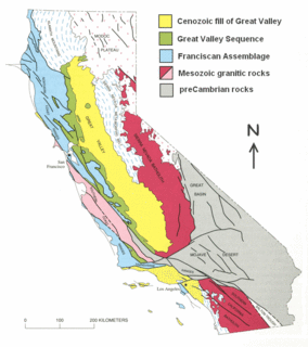
Map modified from Irwin (1990) showing distribution of Great Valley Sequence and Franciscan Assemblage (in blue). Great Valley Sequence map.gif
Map modified from Irwin (1990) showing distribution of Great Valley Sequence and Franciscan Assemblage (in blue).
Diagram (modified from Fig 3.11 in Irwin, 1990) showing the depositional setting of the Franciscan Assemblage and the contemporaneous Great Valley Sequence,. Franciscan subduction model.gif
Diagram (modified from Fig 3.11 in Irwin, 1990) showing the depositional setting of the Franciscan Assemblage and the contemporaneous Great Valley Sequence,.

The Franciscan Complex is an assemblage of metamorphosed and deformed rocks, associated with east-dipping subduction zone at the western coast of North America. [6] Although most of the Franciscan is Early/Late Jurassic through Cretaceous in age (150-66 Ma), [7] some Franciscan rocks are as old as early Jurassic (180-190 Ma) age and as young as Miocene (15 Ma). [8] The different age distribution represents the temporal and spatial variation of mechanisms that operated within the subduction zone. [9] Franciscan rocks are thought to have formed prior to the creation of the San Andreas Fault when an ancient deep-sea trench existed along the California continental margin. This trench, the remnants of which are still active in the Cascadia and Cocos subduction zone, resulted from subduction of oceanic crust of the Farallon tectonic plate beneath continental crust of the North American Plate. As oceanic crust descended beneath the continent, ocean floor basalt and sediments were subducted and then tectonically underplated to the upper plate. [10] This resulted in widespread deformation with the generation of thrust faults and folding, and caused high pressure-low temperature regional metamorphism. [10] In the Miocene, the Farallon-Pacific spreading center reached the Franciscan trench and the relative motion between Pacific-North America caused the initiation of the San Andreas Fault. Transform motion along the San Andreas Fault obscured and displaced the subduction related structures, resulting in overprinting of two generations of structures. [11]

Subduction zone metamorphism Changes of rock due to pressure and heat near a subduction zone

A subduction zone is a region of the earth's crust where one tectonic plate moves under another tectonic plate; oceanic crust gets recycled back into the mantle and continental crust gets created by the formation of arc magmas. Arc magmas account for more than 20% of terrestrially produced magmas and are produced by the dehydration of minerals within the subducting slab as it descends into the mantle and are accreted onto the base of the overriding continental plate. Subduction zones host a unique variety of rock types created by the high-pressure, low-temperature conditions a subducting slab encounters during its descent. The metamorphic conditions the slab passes through in this process creates and destroys water bearing (hydrous) mineral phases, releasing water into the mantle. This water lowers the melting point of mantle rock, initiating melting. Understanding the timing and conditions in which these dehydration reactions occur, is key to interpreting mantle melting, volcanic arc magmatism, and the formation of continental crust.

The Late Jurassic is the third epoch of the Jurassic period, and it spans the geologic time from 163.5 ± 1.0 to 145.0 ± 0.8 million years ago (Ma), which is preserved in Upper Jurassic strata.

The Cretaceous is a geologic period and system that spans from the end of the Jurassic Period 145 million years ago (mya) to the beginning of the Paleogene Period 66 mya. It is the last period of the Mesozoic Era, and the longest period of the Phanerozoic Eon. The Cretaceous Period is usually abbreviated K, for its German translation Kreide.

Shale matrix melange with clasts of sandstone and greenstone on Marshall's Beach, San Francisco, USA Shale matrix melange with clasts of sandstone and greenstone on Marshall's Beach, San Francisco, USA.jpg
Shale matrix mélange with clasts of sandstone and greenstone on Marshall's Beach, San Francisco, USA

Description

Ribbon Chert of the Marin Headlands Terrane, exposed at Marshall's Beach, San Francisco. Ribbon chert of the Marin Headlands Terrane, exposed at Marshall's Beach, San Francisco.jpg
Ribbon Chert of the Marin Headlands Terrane, exposed at Marshall's Beach, San Francisco.
Pillow structures preserved in greenschist-facies metamorphosed basalts of the Franciscan Complex, Black Sands Beach, Marin Headlands, California. Field of view is approximately 2 m wide. Pillow Basalts.jpg
Pillow structures preserved in greenschist-facies metamorphosed basalts of the Franciscan Complex, Black Sands Beach, Marin Headlands, California. Field of view is approximately 2 m wide.
Folded blue metacherts with glaucophane-rich layers, exposed in outcrops on Kayak Beach, Angel Island, northern San Francisco Bay. Blue folded metacherts with glaucophane-rich (ashy%3F) layers.jpg
Folded blue metacherts with glaucophane-rich layers, exposed in outcrops on Kayak Beach, Angel Island, northern San Francisco Bay.
Sheared block-in-matrix fabric composed of serpentinite blocks in serpentinite matrix, exposed on Perles Beach, Angel Island, Marin County, California. Pencil for scale. The strong anastomosing foliation is folded, sub-vertical in the lower part of the photo and more gently dipping in the upper part of the photo. Sheared Serpentinite.jpg
Sheared block-in-matrix fabric composed of serpentinite blocks in serpentinite matrix, exposed on Perles Beach, Angel Island, Marin County, California. Pencil for scale. The strong anastomosing foliation is folded, sub-vertical in the lower part of the photo and more gently dipping in the upper part of the photo.
Shale matrix melange of the Franciscan Complex at Marshall's Beach, San Francisco, California. Sandstone blocks (light grey) contain white mineral veins. Dark grey shale matrix displays strongly foliated anastomosing scaly fabric. Geologist John Wakabayashi for scale. Shale matrix melange.jpg
Shale matrix mélange of the Franciscan Complex at Marshall's Beach, San Francisco, California. Sandstone blocks (light grey) contain white mineral veins. Dark grey shale matrix displays strongly foliated anastomosing scaly fabric. Geologist John Wakabayashi for scale.

The units of the Franciscan complex are aligned parallel to the active margin between the North American and Pacific plates. [12] The Franciscan Complex is in contact with the Great Valley Sequence, with a continuous sheet of serpentinite at its base, along its eastern side. [13] [14] The type area of Franciscan rocks in San Francisco consists of metagraywackes, gray claystone and shale, thin bedded ribbon chert with abundant radiolarians, altered submarine pillow basalts (greenstone) and blueschists. [15] Broadly, the Franciscan can be divided into two groups of rocks. Coherent terranes are internally consistent in metamorphic grade and includes folded and faulted clastic sediments, cherts and basalts, ranging from sub-metamorphic to prehnite-pumpellyite or low-temperature blueschist (jadeite-bearing) grades of metamorphism. Mélange terranes are much smaller, found between or within the larger coherent terranes and sometimes contain large blocks of metabasic rocks of higher metamorphic grade (amphibolite, eclogite, and garnet-blueschist). [10] The mélange zones in the Franciscan usually have a block in matrix appearance with higher grade metamorphic blocks (blueschist, amphibolite, greenschist, eclogite) embedded within the mélange matrix. [16] The matrix material of the mélanges are mudstone or serpentinite. Geologists have argued for either a tectonic or olistostormal origin. [17] In the northern Coast Ranges, the Franciscan has been divided into the Eastern, Central and Coastal Belts based on metamorphic age and grade, with the rocks younging and the metamorphic grade decreasing to the west. [18] [19] [10] The Franciscan varies along strike, because individual accreted elements (packets of trench sediment, seamounts, etc.) did not extend the full length of the trench. Different depths of underplating, distribution of post-metamorphic faulting, and level of erosion produced the present-day surface distribution of high P/T metamorphism. [9] [10]

North American Plate Large tectonic plate including most of North America, Greenland and a bit of Siberia

The North American Plate is a tectonic plate covering most of North America, Greenland, Cuba, the Bahamas, extreme northeastern Asia, and parts of Iceland and the Azores. With an area of 76,000,000 km2 (29,000,000 sq mi), it is the Earth's second largest tectonic plate, behind the Pacific Plate.

Pacific Plate An oceanic tectonic plate under the Pacific Ocean

The Pacific Plate is an oceanic tectonic plate that lies beneath the Pacific Ocean. At 103 million square kilometres (40,000,000 sq mi), it is the largest tectonic plate.

Great Valley Sequence A group of late Mesozoic formations in the Cental Valley of California

The Great Valley Sequence of California is a 40,000-foot (12 km)-thick group of related geologic formations that are Late Jurassic through Cretaceous in age on the geologic time scale. These sedimentary rocks were deposited during the late Mesozoic Era in an ancient seaway that corresponds roughly to the outline of the modern Great Valley of California.

Fossils

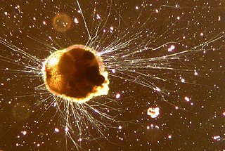
Franciscan sediments contain a sparse, but diverse assemblage of fossils. The most abundant fossils by far are microfossils, particularly in the cherts, which contain single-celled organisms called radiolarians that have exoskeletons of silica. There are also in some of the shales microfossils of planktonic foraminifera that have exoskeletons of carbonate. These microfossils, by and large, indicate deposition in an open-water setting where deep-water conditions exist. [20] Vertebrate fossils in the Franciscan are extremely rare, but include three Mesozoic marine reptiles that are shown in the table below. [21] Again, these indicate an open-water, and therefore deep-marine setting. Although rare, a few shallow-marine fossils have been found as well, and include extinct oysters (Inoceramus) and clams (Buchia). [20] Microfossils in the Calera Limestone member of the Franciscan exposed at the Permanente and Pacifica cement quarries also indicate a shallow-marine setting, with deposition on top of a seamount in the tropical Pacific Ocean and subsequent transport and accretion by the Pacific Plate onto the California continental margin. [22] Thus, even though most of the Franciscan appears to have been deposited in a deep-water setting, it is a complex and diverse assemblage of rocks, and shallow-water settings, though not the norm, existed as well.

Exoskeleton External skeleton of an organism

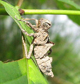
An exoskeleton is the external skeleton that supports and protects an animal's body, in contrast to the internal skeleton (endoskeleton) of, for example, a human. In usage, some of the larger kinds of exoskeletons are known as "shells". Examples of animals with exoskeletons include insects such as grasshoppers and cockroaches, and crustaceans such as crabs and lobsters, as well as the shells of certain sponges and the various groups of shelled molluscs, including those of snails, clams, tusk shells, chitons and nautilus. Some animals, such as the tortoise, have both an endoskeleton and an exoskeleton.

Foraminifera Phylum of amoeboid protists

Foraminifera are members of a phylum or class of amoeboid protists characterized by streaming granular ectoplasm for catching food and other uses; and commonly an external shell of diverse forms and materials. Tests of chitin are believed to be the most primitive type. Most foraminifera are marine, the majority of which live on or within the seafloor sediment, while a smaller variety float in the water column at various depths. Fewer are known from freshwater or brackish conditions, and some very few (nonaquatic) soil species have been identified through molecular analysis of small subunit ribosomal DNA.

Carbonate Salt or ester of carbonic acid

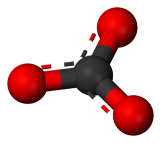
In chemistry, a carbonate is a salt of carbonic acid (H2CO3), characterized by the presence of the carbonate ion, a polyatomic ion with the formula of CO2−
3
. The name may also refer to a carbonate ester, an organic compound containing the carbonate group C(=O)(O–)2.

Mesozoic Vertebrate Fossils of the Franciscan Assemblage
GenusSpeciesNotes
Ichthyosaurus californicus [23] Name means "fish-lizard of California." Found in 1935 in Stanislaus County in a piece of Franciscan chert from the Coast Ranges washed into the Great Valley.
franciscanus [23] Name means "fish-lizard of the Franciscan." Found in 1940 in San Joaquin County in a piece of Franciscan chert from the Coast Ranges washed into the Great Valley.
Plesiosaurus hesternus [23] Name means "one who is near to being a lizard of the West coast." Found in 1949 in San Luis Obispo County in a limestone concretion in Franciscan-Knoxville shales.

Economic importance

Although no significant accumulations of oil or gas have been found in the Franciscan, other opportunities have been exploited over the years. During the 19th century when gold mining was one of the main industries in California, cinnabar associated with serpentine in the Franciscan was mined for quicksilver (mercury) needed to process gold ore and gold-bearing gravels. Some of the more important mines were those at New Idria and New Almaden, the Sulphur Bank Mine at Clearlake Oaks, and the Knoxville Mine (cf. McLaughlin Mine) and others at Knoxville. The Franciscan also contains large bodies of limestone pure enough for making cement, and the Permanente Quarry near Cupertino, California is a giant open-pit mine in a body of Franciscan limestone that supplied most of the cement for building the Shasta Dam across the Sacramento River. [24] The Rockaway Beach Quarry at Pacifica is another example of a major limestone quarry in the Franciscan.

See also

Notes

  1. Bailey, Irwin and Jones (1964), p. 15-17.
  2. Oregon Coast Range simplified geologic map
  3. Tulane University - Regional Metamorphism
  4. Irwin, William P. (1990). Wallace, Robert E. (ed.). "Geology and plate-tectonic Development". The San Andreas Fault System, California-U.S. Geological Survey Professional Paper. 1515: 61–82.
  5. Irwin, William P. (1990). Wallace, Robert E. (ed.). "Geology and plate-tectonic development". The San Andreas Fault System, California. U.S. Geological Survey Professional Paper. 1515: p.74.CS1 maint: extra text (link)
  6. HAMILTON, WARREN (1969). "Mesozoic California and the Underflow of Pacific Mantle". Geological Society of America Bulletin. 80 (12): 2409. doi:10.1130/0016-7606(1969)80[2409:mcatuo]2.0.co;2. ISSN   0016-7606.
  7. Bailey, Irwin and Jones (1964), p. 142-146; Blome and Irwin (1983), p. 77-89..
  8. McLaughlin (1982), p. 595-605.
  9. 1 2 Mulcahy, Sean R.; Starnes, Jesslyn K.; Day, Howard W.; Coble, Matthew A.; Vervoort, Jeffrey D. (May 2018). "Early Onset of Franciscan Subduction". Tectonics. 37 (5): 1194–1209. doi:10.1029/2017tc004753. ISSN   0278-7407.
  10. 1 2 3 4 5 Wakabayashi, John (1992-01-01). "Nappes, Tectonics of Oblique Plate Convergence, and Metamorphic Evolution Related to 140 Million Years of Continuous Subduction, Franciscan Complex, California". The Journal of Geology. 100 (1): 19–40. doi:10.1086/629569. ISSN   0022-1376.
  11. Wentworth et al. (1984), p. 163-173; Irwin (1990), p. 61-82.
  12. Wassmann, Sara; Stöckhert, Bernhard (2012-09-28). "Matrix deformation mechanisms in HP-LT tectonic mélanges — Microstructural record of jadeite blueschist from the Franciscan Complex, California". Tectonophysics. Chaos and Geodynamics: Melanges, Melange Forming Processes and Their Significance in the Geological Record. 568-569: 135–153. doi:10.1016/j.tecto.2012.01.009. ISSN   0040-1951.
  13. Ernst, W. G. (1970). "Tectonic contact between the Franciscan Mélange and the Great Valley Sequence—Crustal expression of a Late Mesozoic Benioff Zone". Journal of Geophysical Research (1896-1977). 75 (5): 886–901. doi:10.1029/JB075i005p00886. ISSN   2156-2202.
  14. Turner, Francis J. (1981). Metamorphic petrology : mineralogical, field, and tectonic aspects (2d ed ed.). Washington: Hemisphere Pub. Corp. ISBN   0070655014. OCLC   5894059.CS1 maint: extra text (link)
  15. Wahrhaftig, Clyde (1984). A Streetcar to Subduction and Other Plate Tectonic Trips by Public Transport in San Francisco. Washington, D. C.: American Geophysical Union. ISBN   0875902340.
  16. Hsü, K. Jinghwa (1968-08-01). "Principles of Mélanges and Their Bearing on the Franciscan-Knoxville Paradox". GSA Bulletin. 79 (8): 1063–1074. doi:10.1130/0016-7606(1968)79[1063:POMATB]2.0.CO;2. ISSN   0016-7606.
  17. Wakabayashi, John (August 2011), "Mélanges of the Franciscan Complex, California: Diverse structural settings, evidence for sedimentary mixing, and their connection to subduction processes", Geological Society of America Special Papers, Geological Society of America, pp. 117–141, ISBN   9780813724805 , retrieved 2019-11-16
  18. James O. Berkland (2), Loren A. Ray (1972). "What is Franciscan?". AAPG Bulletin. 56. doi:10.1306/819a421a-16c5-11d7-8645000102c1865d. ISSN   0149-1423.
  19. Blake, M.C.; Howell, D.G.; Jones, David Lawrence (1982). "Preliminary tectonostratigraphic terrane map of California". Open-File Report. doi:10.3133/ofr82593. ISSN   2331-1258.
  20. 1 2 Bailey, Irwin and Jones (1965), p. 115-123; Blome and Irwin (1983), p. 77-89.
  21. Hilton (2003), p. 223-225.
  22. Tarduno et al. (1985), p. 345-347.
  23. 1 2 3 Hilton (2003), "Appendix: Summary of the Mesozoic Reptilian Fossils of California," p. 272-273.
  24. Austin, Donna (26 June 2009). "Kaiser dug for cement and hit aluminum foil". Cupertino News (newspaper - online edition). Retrieved 14 June 2013. Also see the following online anonymous article "Henry Kaiser's Legacy Woven into Rich California Tapestry". Kasier Permanente. 26 November 2009. Retrieved 14 June 2013.

Related Research Articles

Metamorphism The change of minerals in pre-existing rocks without melting into liquid magma

Metamorphism is the change of minerals or geologic texture in pre-existing rocks (protoliths), without the protolith melting into liquid magma. The change occurs primarily due to heat, pressure, and the introduction of chemically active fluids. The chemical components and crystal structures of the minerals making up the rock may change even though the rock remains a solid. Changes at or just beneath Earth's surface due to weathering or diagenesis are not classified as metamorphism. Metamorphism typically occurs between diagenesis, and melting (~850°C).

Transverse Ranges mountain range in California

The Transverse Ranges are a group of mountain ranges of southern California, in the Pacific Coast Ranges physiographic region in North America. The Transverse Ranges begin at the southern end of the California Coast Ranges and lie within Santa Barbara, Ventura, Los Angeles, San Bernardino, Riverside and Kern counties. The Peninsular Ranges lie to the south. The name Transverse Ranges is due to their east–west orientation, making them transverse to the general northwest–southeast orientation of most of California's coastal mountains.

Eclogite A dense, mafic metamorphic rock

Eclogite is a mafic metamorphic rock. Eclogite forms at pressures greater than those typical of the crust of the Earth. An unusually dense rock, eclogite can play an important role in driving convection within the solid Earth.

Blueschist A metavolcanic rock that forms by the metamorphism of basalt and rocks with similar composition

Blueschist, also called glaucophane schist, is a metavolcanic rock that forms by the metamorphism of basalt and rocks with similar composition at high pressures and low temperatures, approximately corresponding to a depth of 15 to 30 kilometers. The blue color of the rock comes from the presence of the predominant minerals glaucophane and lawsonite.

The Antler orogeny was a tectonic event that began in the early Late Devonian with widespread effects continuing into the Mississippian and early Pennsylvanian. Most of the evidence for this event is in Nevada but the limits of its reach are unknown. A great volume of conglomeratic deposits of mainly Mississippian age in Nevada and adjacent areas testifies to the existence of an important tectonic event, and implies nearby areas of uplift and erosion, but the nature and cause of that event are uncertain and in dispute. Although it is known as an orogeny, some of the classic features of orogeny as commonly defined such as metamorphism, and granitic intrusives have not been linked to it. In spite of this, the event is universally designated as an orogeny and that practice is continued here. This article outlines what is known and unknown about the Antler orogeny and describes three current theories regarding its nature and origin.

The Nevadan orogeny occurred along the western margin of North America during the Middle Jurassic to Early Cretaceous time which is approximately from 155 Ma to 145 Ma. Throughout the duration of this orogeny there were at least two different kinds of orogenic processes occurring. During the early stages of orogenesis an "Andean type" continental magmatic arc developed due to subduction of the Farallon oceanic plate beneath the North American Plate. The latter stages of orogenesis, in contrast, saw multiple oceanic arc terranes accreted onto the western margin of North America in a "Cordilleran type" accretionary orogen. Deformation related to the accretion of these volcanic arc terranes is mostly limited to the western regions of the resulting mountain ranges and is absent from the eastern regions. In addition, the deformation experienced in these mountain ranges is mostly due to the Nevadan orogeny and not other external events such as the more recent Sevier and Laramide Orogenies. It is noted that the Klamath Mountains and the Sierra Nevada share similar stratigraphy indicating that they were both formed by the Nevadan orogeny. In comparison with other orogenic events, it appears that the Nevadan Orogeny occurred rather quickly taking only about 10 million years as compared to hundreds of millions of years for other orogenies around the World.

Mélange A large-scale breccia typically consisting of a jumble of large blocks of varied lithologies

In geology, a mélange is a large-scale breccia, a mappable body of rock characterized by a lack of continuous bedding and the inclusion of fragments of rock of all sizes, contained in a fine-grained deformed matrix. The mélange typically consists of a jumble of large blocks of varied lithologies. Both tectonic and sedimentary processes can form mélange.

Mendocino Triple Junction The point where the Gorda plate, the North American plate, and the Pacific plate meet

The Mendocino Triple Junction (MTJ) is the point where the Gorda plate, the North American plate, and the Pacific plate meet, in the Pacific Ocean near Cape Mendocino in northern California. This triple junction is the location of a change in the broad plate motions which dominate the west coast of North America, linking convergence of the northern Cascadia subduction zone and translation of the southern San Andreas Fault system. The Gorda plate is subducting, towards N50ºE, under the North American plate at 2.5 – 3 cm/yr, and is simultaneously converging obliquely against the Pacific plate at a rate of 5 cm/yr in the direction N115ºE. The accommodation of this plate configuration results in a transform boundary along the Mendocino Fracture Zone, and a divergent boundary at the Gorda Ridge.

The Farallon Trench was a subduction related tectonic formation located off the coast of the western California continental margin during the late to mid Cenozoic era, around 50 miles southeast of modern-day Monterey Bay. The time duration of subduction began from around 165 Ma when the Farallon Plate replaced the Mezczlera promontory, until the San Andreas Fault straightening around 35 Ma. As data accumulated over time, a common view developed that one large oceanic plate, the Farallon Plate, acted as a conveyor belt, conveying accreted terranes onto the North American west coast. As the continent overran the subducting Farallon Plate, the denser plate became subducted into the mantle below the continent. When the plates converged, the dense oceanic plate sank into the mantle to form a slab below the lighter continent. Rapid subduction under the southwestern North America continent began 40 to 60 million years ago (Ma), during the mid Paleocene to mid Eocene epochs. This convergent subduction margin created a distinctive geomorphologic feature called an oceanic trench, which occurs at a convergent plate boundaries as a heavy metal rich, lithospheric plate moves below a light silica rich continental plate. The trench marks the position at which the flexed subducting slab begins to descend beneath and deform the continental plate margin. By 43 Ma, during the Eocene, worldwide plate motions changed and the Pacific Plate began to move away from North America and subduction of the Farallon Plate slowed dramatically. By around 36 Ma, the easternmost part of the East Pacific Rise, located between the Pioneer and Murray fracture zones at that time, approached the trench and the young, hot, buoyant lithosphere appears to have clogged part of the subduction zone, resulting in widespread dramatic uplift on land. The eventual complete subduction of this plate, consequential contact of the Pacific Plate with the California continental margin, and creation of the Mendocino Triple Junction (MTJ), took place around 30 to 20 Ma. The partial complete subduction and division of the Farallon Plate by the Pacific Plate, created the Juan de Fuca Plate to the north and the Cocos Plate to the south. The final stages of the evolution of California's continental margin was the growth of the San Andres transform fault system, which formed as the Pacific Plate came into contact with the continental margin and the MTJ was formed. As subduction of the Pacific Plate continued along this margin, and the contact zone grew, the San Andres proportionally grew as well.

Accretionary wedge The sediments accreted onto the non-subducting tectonic plate at a convergent plate boundary

An accretionary wedge or accretionary prism forms from sediments accreted onto the non-subducting tectonic plate at a convergent plate boundary. Most of the material in the accretionary wedge consists of marine sediments scraped off from the downgoing slab of oceanic crust, but in some cases the wedge includes the erosional products of volcanic island arcs formed on the overriding plate.

The Wrangellia Terrane is a terrane extending from the south-central part of Alaska through southwestern Yukon and along the Coast of British Columbia in Canada. Some workers contend that Wrangellia extends southward to Oregon, although this is not generally accepted.

The Lachlan Fold Belt (LFB) or Lachlan Orogen is a geological subdivision of the east part of Australia. It is a zone of folded and faulted rocks of similar age. It dominates New South Wales and Victoria, also extending into Tasmania, the Australian Capital Territory and Queensland. It was formed in the Middle Paleozoic from 450 to 340 Mya. It was earlier known as Lachlan Geosyncline. It covers an area of 200,000 km2.

Ring Mountain (California) mountain in United States of America

Ring Mountain is an elevated landform on the Tiburon Peninsula in Marin County, California. This mountain was named for George E. Ring, who served as a Marin County Supervisor from 1895 to 1903.

The Sonoma orogeny was a period of mountain building in western North America. The exact age and structure of the Sonoma orogeny is controversial. The orogeny is generally thought to have occurred during the Permian / Triassic transition, around 250 million years ago, following the Late Devonian Antler orogeny. The Sonoma orogeny was one of a sequence of accretionary events along the Cordilleran margin, possibly caused by the closure of the basin between the island arc of Sonomia and the North American continent. Evidence of this event has been reported throughout western North America, but most distinctly in northwest Nevada.

High pressure metamorphic terranes along the Bangong-Nujiang Suture Zone

High pressure terranes along the ~1200 km long east-west trending Bangong-Nujiang suture zone (BNS) on the Tibetan Plateau have been extensively mapped and studied. Understanding the geodynamic processes in which these terranes are created is key to understanding the development and subsequent deformation of the BNS and Eurasian deformation as a whole.

Paired metamorphic belts are sets of parallel linear rock units that display contrasting metamorphic mineral assemblages. These paired belts develop along convergent plate boundaries where subduction is active. Each pair consists of one belt with a low-temperature, high-pressure metamorphic mineral assemblage, and another characterized by high-temperature, low-pressure metamorphic minerals.

Lhasa terrane A fragment of crustal material, sutured to the Eurasian Plate during the Cretaceous that forms present-day southern Tibet

The Lhasa terrane is a terrane, or fragment of crustal material, sutured to the Eurasian Plate during the Cretaceous that forms present-day southern Tibet. It takes its name from the city of Lhasa in the Tibet Autonomous Region, China. The northern part may have originated in the East African Orogeny, while the southern part appears to have once been part of Australia. The two parts joined, were later attached to Asia, and then were impacted by the collision of the Indian Plate that formed the Himalayas.

The geology of Alaska includes Precambrian igneous and metamorphic rocks formed in offshore terranes and added to the western margin of North America from the Paleozoic through modern times. The region was submerged for much of the Paleozoic and Mesozoic and formed extensive oil and gas reserves due to tectonic activity in the Arctic Ocean. Alaska was largely ice free during the Pleistocene, allowing humans to migrate into the Americas.

The geology of Ecuador includes ancient Precambrian basement rock and a complex tectonic assembly of new sections of crust from formerly separate landmasses, often uplifted as the Andes or transformed into basins.

References