
The Metro Blue Line is a 12-mile (19.3 km) light rail line in Hennepin County, Minnesota, that is part of the Metro network. It travels from downtown Minneapolis to Minneapolis–Saint Paul International Airport and the southern suburb of Bloomington. Formerly the Hiawatha Line prior to May 2013, the line was originally named after the Milwaukee Road's Hiawatha passenger train and Hiawatha Avenue, reusing infrastructure from the former and running parallel to the latter for a portion of the route. The line opened June 26, 2004, and was the first light rail service in Minnesota. An extension, Bottineau LRT, is planned to open in 2028.
Metro Transit is the primary public transportation operator in the Minneapolis–Saint Paul area of the U.S. state of Minnesota and the largest operator in the state. Although Metro Transit is one of the smallest transit systems for a large metropolitan area in the United States, it has previously been ranked as one of the best. In 2022, the system had a ridership of 38,794,700, or about 138,800 per weekday as of the third quarter of 2023.
The Urban Ring was a proposed project of the Massachusetts Bay Transportation Authority and the Massachusetts Department of Transportation, to develop new public transportation routes that would provide improved circumferential connections among many existing transit lines that project radially from downtown Boston. The Urban Ring Corridor is located roughly one to two miles from downtown Boston, passing through the Massachusetts cities of Boston, Chelsea, Everett, Medford, Somerville, Cambridge, and Brookline. The project was expected to convert 41,500 car trips to transit trips daily.
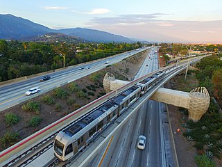
The A Line is a 48.5-mile (78.1 km) light rail line in Los Angeles County, California. The A Line runs east-west between Azusa and Pasadena, then north-south between Pasadena and Long Beach, via Downtown Los Angeles. The A Line is currently the longest light rail line in the world, surpassing the Coast Tram in Belgium.
The Capital Metropolitan Transportation Authority, officially stylized as CapMetro, is a public transportation provider located in Austin, Texas. It operates bus, paratransit services and a hybrid rail system known as CapMetro Rail in Austin and several suburbs in Travis and Williamson counties. In 2022, the system had a ridership of 21,145,300, or about 80,900 per weekday as of the third quarter of 2023.

CapMetro Rail is a hybrid rail system that serves the Greater Austin area in Texas and is owned by CapMetro, Austin's primary public transportation provider. The Red Line is CapMetro's first and currently only rail line, and connects Downtown Austin with Austin's northwestern suburbs. The line operates on 32 miles (51 km) of existing freight tracks, and serves nine stations. After a series of delays, CapMetro Rail was inaugurated in March 2010. CapMetro added Friday evening and Saturday afternoon and evening regularly scheduled service on March 23, 2012. In 2022, the line had a ridership of 466,800, or about 1,500 per weekday as of the third quarter of 2023.
The Metro Purple Line, formerly known as the Rush Line Corridor, is a proposed bus rapid transit service that would run from Union Depot in downtown Saint Paul to the northeastern suburbs of Saint Paul. Along the corridor's 21 proposed stations there are 106,000 jobs within a 10-minute walk. The project is currently in an environmental analysis phase with further development, engineering, and construction expected to take at least six more years. Service would run 7-days a week with 10-minute headways in peak periods and 15-minute service at most other times. The corridor was named the Rush Line because it was originally planned to end in Rush City, Minnesota. After using the color purple since 2017, the route was officially named the Purple Line and became part of the Metro network on July 14, 2021.

The Metro Red Line is a bus rapid transit line between the Twin Cities suburbs of Bloomington, Minnesota and Apple Valley, Minnesota. The Red Line travels primarily on Minnesota State Highway 77 and Cedar Avenue from the Apple Valley station in Apple Valley, north through Eagan, Minnesota, to the Mall of America station in Bloomington where it connects to the Metro Blue Line. The line has bus rapid transit elements including bus-only lanes, specially branded vehicles, transit signal priority, and dedicated stations.
The Minneapolis Streetcar System was a proposed streetcar system for the city of Minneapolis, Minnesota. Extensive studies and plans for the new system were completed in 2007 and presented to the Minneapolis City Council in January 2008; on April 2, 2010, the Council voted to approve the plans and seek funding. On December 21, 2010 the Federal Transit Administration granted $900,000 to further study the Nicollet and Central Avenue corridors. In June 2021, after no further development on the system, a bill authorized the Metropolitan Council to use funds collected for the Nicollet-Central line to be spent on bus rapid transit funding.

The Massachusetts Bay Transportation Authority (MBTA) operates rapid transit, light rail, and bus rapid transit services in the Boston metropolitan area, collectively referred to as the rapid transit, subway, or the T system.

The METRORapid Silver Line is a bus rapid transit line in Houston, Texas operated by METRO. Opened August 23, 2020, the line connects the Uptown area of Houston, with dedicated lanes over nearly the entire length of the corridor. It serves the Northwest Transit Center, 8 stations along Post Oak Boulevard in Uptown, and the Westpark/Lower Uptown Transit Center. On internal METRO documents, the METRORapid Silver Line is designated as Route 433.

RapidRide is a network of limited-stop bus routes with some bus rapid transit features in King County, Washington, operated by King County Metro. The network consists of seven routes totaling 76 miles (122 km) that carried riders on approximately 64,860 trips on an average weekday in 2016, comprising about 17 percent of King County Metro's total daily ridership.

Metro is a transit network in Minnesota serving the cities of Minneapolis and Saint Paul. It also provides service to some suburban areas. As of 2022, the system consists of two light rail lines and five bus rapid transit (BRT) lines all of which are operated by the local public transit company: Metro Transit. The five lines connect Downtown Minneapolis and St Paul with the Bloomington, Minneapolis-St Paul International Airport, Roseville, Richfield, Burnsville and Brooklyn Center.

CapMetro Rapid is a bus rapid transit service in Austin, Texas, owned and operated by the Capital Metropolitan Transportation Authority (CapMetro). It currently consists of two routes which run north-south served by stations designed by McKinney York Architects.
The history of the Los Angeles Metro Rail and Busway system begins in the early 1970s, when the traffic-choked region began planning a rapid transit system. The first dedicated busway opened along I-10 in 1973, and the region's first light rail line, the Blue Line opened in 1990. Today the system includes over 160 miles (260 km) of heavy rail, light rail, and bus rapid transit lines, with multiple new lines under construction as of 2019.
The Blue Line is a planned light rail line for connecting Austin–Bergstrom International Airport with downtown Austin, Texas. It is still in the planning stages as a part of CapMetro's Project Connect. It is estimated to begin revenue service as early as 2029.
Urban rail transit in Canada encompasses a broad range of rail mass transit systems, including commuter rail, rapid transit, light rail, and streetcar systems.

Project Connect is a transit expansion program by the Capital Metropolitan Transportation Authority (CapMetro) in Austin, Texas, U.S. The program was approved by voters on November 3, 2020, in a local election concurrent with the 2020 presidential election.
The Orange Line is a proposed north-south light rail line that will serve the central spine of Austin from North Lamar to Stassney Lane. It is in the planning stages as a part of CapMetro's Project Connect. It is estimated to begin revenue service as early as 2029.
The Downtown Transit Tunnel was a planned light rail tunnel in Downtown Austin, Texas. It was a core feature of the proposed initial investment of Project Connect, the transit expansion plan being undertaken by the Capital Metropolitan Transportation Authority. The transit tunnel would have served the Orange, Blue, and (eventually) Gold light rail lines. The tunnel was eventually cut from Project Connect plans after unexpected cost increases and design challenges.