
Great Sand Dunes National Park and Preserve is an American national park that conserves an area of large sand dunes up to 750 feet (230 m) tall on the eastern edge of the San Luis Valley, and an adjacent national preserve in the Sangre de Cristo Range, in south-central Colorado, United States. The park was originally designated Great Sand Dunes National Monument on March 17, 1932, by President Herbert Hoover. The original boundaries protected an area of 35,528 acres. A boundary change and redesignation as a national park and preserve was authorized on November 22, 2000, and then established on September 24, 2004. The park encompasses 107,342 acres while the preserve protects an additional 41,686 acres for a total of 149,028 acres. The recreational visitor total was 527,546 in 2019.

The Adirondack Park is a part of New York's Forest Preserve in northeastern New York, United States. The park was established in 1892 for “the free use of all the people for their health and pleasure”, and for watershed protection. The park's boundary roughly corresponds with the Adirondack Mountains. Unlike most state parks, about 52 percent of the land is privately-owned inholdings. State lands within the park are known as Forest Preserve. Land use on public and private lands in the park is regulated by the Adirondack Park Agency. This area contains 102 towns and villages, as well as numerous farms, businesses and an active timber-harvesting industry. The year-round population is 132,000, with 200,000 seasonal residents. The inclusion of human communities makes the park one of the great experiments in conservation in the industrialized world. The Forest Preserve was designated a National Historic Landmark in 1963.
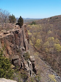
Sleeping Giant is a rugged traprock mountain with a high point of 739 feet (225 m), located eight miles (13 km) north of New Haven, Connecticut. A prominent landscape feature visible for miles, the Sleeping Giant receives its name from its anthropomorphic resemblance to a slumbering human figure as seen from either the north or south. The Giant is known for its expansive clifftop vistas, rugged topography, and microclimate ecosystems. Most of the Giant is located within Sleeping Giant State Park. The mountain is a popular recreation site: over 30 miles (48 km) of hiking trails traverse it including 5 miles (8 km) of the 23-mile (37 km) Quinnipiac Trail. Quinnipiac University is located at Mount Carmel's foot in Hamden.

Pachaug State Forest is the largest forest in the Connecticut state forest system, encompassing over 27,000 acres (110 km²) of land. It is located on the Rhode Island border in New London County, and parcels of the forest lie in the towns of Voluntown, Griswold, Plainfield, Sterling, North Stonington, and Preston. The forest was founded in 1928, but most of the land came from purchases made later during the Great Depression. It is named after the Pachaug River, which runs through the center of the forest. The forest is part of the Northeastern coastal forests ecoregion.

Bartholomew's Cobble is a 329-acre (1.33 km2) National Natural Landmark, open space preserve, agricultural preserve, and bio-reserve located in southwest Massachusetts in the village of Ashley Falls abutting Canaan, Connecticut. The preserve contains over 800 plant species, including North America's greatest diversity of ferns and the greatest overall biodiversity in Berkshire County, Massachusetts; it also contains Massachusetts' highest populations of ground nesting bobolinks. It was declared a National Natural Landmark in October 1971

The Tiger Bay State Forest is in the U.S. state of Florida. The 27,330-acre (11,060 ha) forest is located in Volusia County, Florida, between Daytona Beach and DeLand.

Santiam State Forest is one of six state forests managed by the Oregon Department of Forestry. The forest is located approximately 25 miles (40 km) southeast of Salem, Oregon, and includes 47,871 acres (193.73 km2) on the western slope of the Cascade Mountains in three Oregon counties: Clackamas, Linn, and Marion. It is bounded on the east by the Willamette National Forest and Mount Hood National Forest. Silver Falls State Park is located west of the forest. The rest of the land surrounding the forest belongs to the Bureau of Land Management or is privately owned. The forest is managed as part of the Department of Forestry's North Cascade District. It is the largest single block of state owned forest land in the Cascades.

Kohler-Andrae State Park comprises two adjacent Wisconsin state parks located in the Town of Wilson, a few miles south of the city of Sheboygan. They are managed as one unit. Terry Andrae State Park, established in 1927, and John Michael Kohler State Park, established in 1966, total 988 acres (4.00 km2). The parks contain over two miles (3 km) of beaches and sand dunes along the shore of Lake Michigan, with woods and wetlands away from the water. The Black River flows through the parks.

The Nipmuck Trail is a Blue-Blazed hiking trail "system" which meanders through 34.5 miles (55.5 km) of forests in northeast Connecticut. It is maintained by the Connecticut Forest and Park Association and is considered one of the Blue-Blazed hiking trails. There are two southern trail heads in the south of the town of Mansfield, Connecticut. The southwestern terminus is at a road shoulder parking place on Puddin Lane, and the southeastern terminus is a DEEP parking lot on North Windham Road at the southeast corner of Mansfield Hollow State Park. The northern terminus is at the north end of Breakneck Pond along the Massachusetts border in Nipmuck State Forest. Camping permits may be obtained for up to five separate locations for backpacking.

Spencer State Forest is a Massachusetts state forest and recreation reserve located in the town of Spencer, managed by the Massachusetts Department of Conservation and Recreation. The 92 mile (148 km) Midstate Trail passes through the state forest. The Commonwealth of Massachusetts also conducts logging in some parts of the property.
Noon Hill is a 204-acre (83 ha) open space preserve located in Medfield, Massachusetts and centered on 370-foot (110 m) Noon Hill, a prominent summit and scenic vista. It is managed by the land conservation non-profit organization The Trustees of Reservations and offers 4.5 miles (7.2 km) of trails available for hiking, horseback riding, mountain biking, and cross country skiing. Oak-hickory forest, wetlands, vernal pools, steep ravines, boulders, and rocky ledges characterize the preserve. Noon Hill is a link in the 200-mile (320 km) Bay Circuit Trail. Holt Pond, a constructed mill pond, is located on the property.

Shenipsit State Forest is a state forest located in northeastern Connecticut with 11 parcels scattered between the towns of Somers, Ellington, and Stafford. The forest's headquarters are home to the Civilian Conservation Corps Museum, which houses memorabilia from CCC camps throughout the eastern United States. The forest is managed for forestry products and offers various recreational pursuits.
The Meshomasic State Forest is located in East Hampton, Portland, and Marlborough, Connecticut, with smaller sections located in Glastonbury and Hebron. It is popular for mountain biking, hiking, and hunting. The Rangers Headquarters were located on Gadpouch Road in East Hampton.

The Tunxis Trail is a 79-mile (127 km) Blue-Blazed hiking trail "system" that traverses the western ridge of the central Connecticut Valley. The mainline trail is not completely contiguous, notably there are two gaps of several miles.

The Naugatuck Trail is a 6.8-mile (10.9 km) Blue-Blazed hiking trail "system" in the eastern central-lower Naugatuck River Valley in New Haven County, Connecticut, USA. It is almost entirely contained in the Naugatuck State Forest. The mainline trail is primarily east to west with three short side or spur trails. Composed of four trails, at its western end the trail ends with a section alongside Route 8 and the Naugatuck River. Duringthe 1930s and 1940s, it was much larger. But post–World War II housing developments of the Connecticut Blue-Blazed Trails, led to its drastic reduction.

The Paugussett Trail is a 14-mile (23 km) Blue-Blazed hiking trail "system" in the lower Housatonic River valley in Fairfield County and, today, is entirely in Shelton and Monroe, Connecticut. Much of the trail is in Indian Well State Park and the Town of Monroe's Webb Mountain Park. The mainline trail is primarily southeast to northwest with three short side or spur trails.

The Natchaug Trail is a Blue-Blazed hiking trail "system" which meanders through 19.5 miles (31.4 km) of forests in northeast Connecticut—primarily in Windham County. It is maintained by the Connecticut Forest and Park Association. Its southern trailhead begins in the James L. Goodwin State Forest in the towns of Chaplin, Connecticut and Hampton, Connecticut and the northern terminus is at its intersection with the Nipmuck Trail in Natchaug State Forest in Eastford, Connecticut.

The Narragansett Trail is a 16-mile (26 km) Connecticut hiking trail and is one of the Blue-Blazed hiking trails maintained by the Connecticut Forest and Park Association and the Narragansett Council, the Rhode Island chapter of the Boy Scouts of America.

The White Memorial Foundation is an organization dedicated to environmental conservation located in Litchfield, Connecticut. The Foundation owns approximately 4,000 acres of wetlands and uplands, including recreational trails, two camping areas, and a conservation center dedicated to education, research, conservation, and recreation.

The Labrador Hollow Unique Area is a 1,474-acre (5.97 km2) conservation area located in Cortland and Onondaga counties, New York, and was the first property to be designated as a Unique Area by New York. The area is located adjacent to and between Kettlebail State Forest and Morgan Hill State Forest, and is managed by the New York State Department of Environmental Conservation. The area is open to the public and includes Labrador Pond and Tinker Falls.


