Related Research Articles

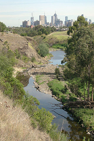
The Maribyrnong River is a perennial river of the Port Phillip catchment, located in the north–western suburbs of Melbourne, in the Australian state of Victoria.

Essendon is a suburb in Melbourne, Victoria, Australia, 8 km (5.0 mi) north-west of Melbourne's central business district, located within the City of Moonee Valley local government area. Essendon recorded a population of 21,240 at the 2021 census.

The Kulin nation is an alliance of five Aboriginal nations in south-up into the Great Dividing Range and the Loddon and Goulburn River valleys.
The Merri Creek is a waterway in southern parts of Victoria, Australia which flows through the northern suburbs of Melbourne. It begins near Wallan and flows south for 70 km until joining the Yarra River at Dights Falls. The area where the creek meets the river was traditionally the location for large gatherings of the Wurundjeri people and is suspected to have been the location for one of the earliest land treaties in Australia between Indigenous Australians and European settlers.

The Maribyrnong River Trail is a shared use path for cyclists and pedestrians, which follows the Maribyrnong River through the north western suburbs of Melbourne, Victoria, Australia.
Avondale Heights is a suburb in Melbourne, Victoria, Australia, 11 km (6.8 mi) north-west of Melbourne's Central Business District, located within the City of Moonee Valley local government area. Avondale Heights recorded a population of 12,388 at the 2021 census.

Brimbank Park is a metropolitan regional park managed by Parks Victoria situated in the north-western Melbourne suburb of Keilor East, Victoria, Australia.

Melbourne is Australia's second largest city and widely considered to be a garden city, with Victoria being nicknamed "the Garden State". Renowned as one of the most livable cities in the world, there is an abundance of parks, gardens and green belts close to the CBD with a variety of common and rare plant species amid landscaped vistas, pedestrian pathways, and tree-lined avenues, all managed by Parks Victoria.

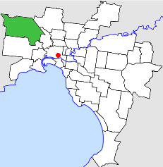
Keilor East is a suburb in Melbourne, Victoria, Australia, 13 km (8.1 mi) north-west of Melbourne's Central Business District, located within the Cities of Brimbank and Moonee Valley local government areas. Keilor East recorded a population of 15,073 at the 2021 census.
The Steele Creek Trail is a shared use path for cyclists and pedestrians, which follows Steele Creek in the Outer North Western suburbs of Keilor Park, Keilor East, Tullamarine, Airport West, Melbourne Airport, Avondale heights, Essendon West and Niddrie in Melbourne.
The Taylors Creek Trail is a shared use path for cyclists and pedestrians, which follows Taylors Creek in the outer north-west suburb of Taylors Lakes in Melbourne, Victoria, Australia.
The City of Keilor was a local government area about 13 kilometres (8 mi) northwest of Melbourne, the state capital of Victoria, Australia. The city covered an area of 99.70 square kilometres (38.49 sq mi), and existed from 1863 until 1994.
The Archaeological Society of Victoria was formed in 1964 from the efforts of University of Melbourne academic William (Bill) Culican in response to the enthusiastic response to his archaeology lectures run through the CAE. In 1976 it combined with the Anthropological Society of Victoria to create the Archaeological and Anthropological Society of Victoria or AASV. Among its contribution to the archaeology discipline in Victoria, it undertook excavations at Dry Creek, Keilor in the early 1970s, to uncover evidence of Pleistocene Aboriginal occupation.
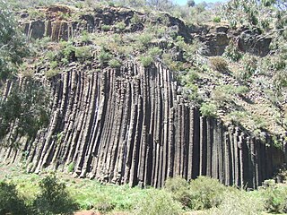
The Organ Pipes National Park, abbreviated as OPNP, is a national park located in the Central region of Victoria, Australia. The 121-hectare (300-acre) protected area was established with the focus on conservation of the native flora and fauna, and preservation of the geological features in the Jacksons Creek, a part of the Maribyrnong valley, north-west of Melbourne. It is situated in a deep gorge in the grassy, basalt Keilor Plains.

Aboriginal Victorians, the Aboriginal Australians of Victoria, Australia, occupied the land for tens of thousands of years prior to European settlement. Aboriginal people have lived a semi-nomadic existence of fishing, hunting and gathering and associated activities for at least 40,000 years.

The Sunbury Earth Rings are prehistoric Aboriginal sites located on the hills to the west of Jacksons Creek near Sunbury, Victoria, Australia.
The Keilor archaeological site was among the first places to demonstrate the antiquity of Aboriginal occupation of Australia when a cranium, unearthed in 1940, was found to be nearly 15,000 years old. Subsequent investigations of Pleistocene alluvial terraces revealed hearths about 31,000 years BP, making Keilor one of the earliest sites of human habitation in Australia. Remains of megafauna suggest a possible association with Aboriginal hunting.
Aboriginal sites of Victoria form an important record of human occupation for probably more than 40,000 years. They may be identified from archaeological remains, historical and ethnographic information or continuing oral traditions and encompass places where rituals and ceremonies were performed, occupation sites where people ate, slept and carried out their day to day chores, and ephemeral evidence of people passing through the landscape, such as a discarded axe head or isolated artefact.

The Woiwurrung, also spelt Woi-wurrung, Woi Wurrung, Woiwurrong, Woiworung, Wuywurung, are an Aboriginal Australian people of the Woiwurrung language group, in the Kulin alliance.
Sandor (Alexander) Gallus was a Melbourne archaeologist, most famous for his investigations of Pleistocene Aboriginal occupation at Koonalda Cave in South Australia and the Dry Creek archaeological site in Keilor, Australia, which helped demonstrate the great antiquity of Aboriginal occupation of Australia.
References
- ↑ Macintosh, N. W. G., 1967. Fossil man in Australia with particular reference to the 1965 discovery at Green Gully near Keilor, Victoria. Aust. J. Sci. 30: 86-98.
- ↑ "Victorian Resources Online, K14 Green Gully (Taylors Creek) - Terraces". Archived from the original on 2018-11-13. Retrieved 2018-11-13.
- ↑ Joyce, Edmund Bernard (1970), An archive of studies on the geology and archaeology of the Keilor Terraces and the Maribyrnong River Valley, archived from the original on 29 April 2024, retrieved 13 November 2018
- ↑ "J. M. Bowler ALLUVIAL TERRACES IN THE MARIBYRNONG VALLEY NEAR KEILOR, VICTORIA, Memoirs of the National Museum of Victoria 1970 p.15" (PDF). Archived (PDF) from the original on 2018-07-21. Retrieved 2018-11-13.
- ↑ "Catalogue of Fossil Hominids Database 6460+-190 BP(NZ-676)". Archived from the original on 2018-11-13. Retrieved 2018-11-13.