Light Regional Council is a local government area north of Adelaide in South Australia. It is based in the town of Kapunda, and includes the towns of Freeling, Greenock, Hansborough, Hewett, Roseworthy and Wasleys.
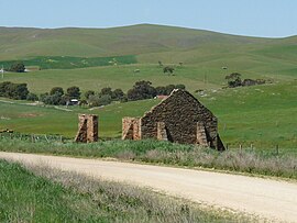
Hamilton is a small township in the Mount Lofty Ranges in South Australia. It is about 120 km northeast of Adelaide, South Australia, about 23 km north of Kapunda. Once a stop for the mining carts going from Adelaide to Burra, but now just a small agricultural district.

The Regional Council of Goyder is a local government area located in the Mid North region of South Australia. The council area is reliant on agriculture as a mainstay of its economy, with manufacturing and tourism also becoming prominent. The council seat lies at Burra, with a branch office situated at Eudunda.
Dutton is a settlement in South Australia. The small township lies approximately six kilometres (3.7 mi) north of Truro on the Eudunda Road. It was first laid out in 1866 and lots were advertised for sale in the German-language newspaper Südaustralische Zeitung.
Hynam is a town and locality in the Australian state of South Australia located in the state's south-east within the Limestone Coast region on the border with the state of Victoria about 302 kilometres south east of the state capital of Adelaide and about 11 kilometres east of the municipal seat of Naracoorte.

The Light River, commonly called the River Light, is a seasonal and significant river in the Mid North region of the Australian state of South Australia named for early surveyor William Light.
Bagot Well is a locality around 6 km north-east of Kapunda, South Australia on the road to Eudunda and was named for Captain C. H. Bagot, who owned a great deal of property in the area.

Mount Mary is a small town on the Thiele Highway between Eudunda and Morgan in South Australia. It was also served by the Morgan railway line from 1878 until 1969 and is named for the Mount Mary railway station on that line.
Beatty is a rural locality in the Australian state of South Australia located in the state's east within the Murray and Mallee region about 126 kilometres (78 mi) north-east of the state capital of Adelaide and about 99 kilometres (62 mi) north of the municipal seat of Mannum.
The District Council of Julia was a local government area in South Australia from 1874 to 1932. The council seat was located at Hampden.

Walloway is a locality in the Australian state of South Australia located about 255 kilometres (158 mi) north of the state capital of Adelaide and about 10 kilometres (6.2 mi) north of the municipal seat of Orroroo.
Buchanan is a rural locality in the Mid North region of South Australia, situated in the Regional Council of Goyder. It was established in August 2000, when boundaries were formalised for the "long established local name".
Frankton is a rural locality in the Mid North region of South Australia, situated in the Regional Council of Goyder and Mid Murray Council. The section within the Goyder council was established in August 2000, when boundaries were formalised for the "long established local name"; the section within the Mid Murray council was added in March 2003. It is believed to be named after the son of two early residents, Mr. and Mrs. Rice.
Custon is a locality in the Australian state of South Australia located in the state's south-east within the Limestone Coast region about 267 kilometres south east of the state capital of Adelaide, about 19.5 kilometres south-east of the municipal seat of Bordertown and adjoining the border with the State of Victoria.
Minburra is a locality in the Australian state of South Australia located about 265 kilometres (165 mi) north of the state capital of Adelaide and about 29 kilometres (18 mi) north-east of the municipal seat in Orroroo.

The Hundred of Kapunda is a cadastral unit of hundred in the County of Light, South Australia in the lower Mid North just north of the Barossa Valley. Named for the Kapunda copper mine in the 1850s which in turn is thought to have been a corruption of the indigenous word cappieoonda, referring to the spring which supplied water to the town. The hundred is bounded on the south by the River Light

Stephenston is a locality in the Australian state of South Australia located on the eastern side of the Flinders Ranges about 285 kilometres (177 mi) north of the state capital of Adelaide and about 15 kilometres (9.3 mi) east of the municipal seat of Quorn.
Wombats Rest is a locality in the Australian state of South Australia located in the state’s east on the western side of the Murray River about 133 kilometres (83 mi) north-east of the state capital of Adelaide and about 94 kilometres (58 mi) north-east of the municipal seat of Mannum.
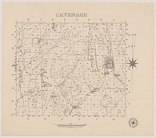
Cavenagh is a locality in the Australian state of South Australia located about 247 kilometres (153 mi) north of the state capital of Adelaide and about 37 kilometres (23 mi) north-east of the municipal seat in Peterborough.
Chiton is a locality in the Australian state of South Australia located on the south coast of Fleurieu Peninsula about 67 kilometres (42 mi) south of the state capital of Adelaide and about 11 kilometres (6.8 mi) west of the municipal seat of Goolwa.