Hipour was a master navigator from the navigational school of Weriyeng and the island of Puluwat.
He is notable for teaching author Thomas Gladwin the art of navigation for his 1970 book, East Is a Big Bird , [1] which greatly reinvigorated interest in traditional Pacific celestial navigation.
Hipour also accompanied David Henry Lewis on his ketch Isbjorn from Puluwat to Saipan and back, using traditional navigation techniques, which helped to fuel a renaissance in voyaging between the Caroline and Mariana Islands. [2]
Micronesia is a subregion of Oceania, consisting of approximately 2,000 small islands in the Northwestern Pacific Ocean. It has a close shared cultural history with three other island regions: Maritime Southeast Asia to the west, Polynesia to the east, and Melanesia to the south—as well as with the wider community of Austronesian peoples.
The Caroline Islands are a widely scattered archipelago of tiny islands in the western Pacific Ocean, to the north of New Guinea. Politically, they are divided between the Federated States of Micronesia (FSM) in the central and eastern parts of the group, and Palau at the extreme western end. Historically, this area was also called Nuevas Filipinas or New Philippines, because they were part of the Spanish East Indies and were governed from Manila in the Philippines.
The Santa Cruz Islands form an archipelago in Temotu Province, Solomon Islands. They lie approximately 250 miles to the southeast of the Solomon Islands archipelago, just north of the archipelago of Vanuatu and are considered part of the Vanuatu rain forests ecoregion. The term Santa Cruz Islands is sometimes used to encompass all the islands of Temotu Province, Solomon Islands.
The Polynesian Voyaging Society (PVS) is a non-profit research and educational corporation based in Honolulu, Hawaiʻi. PVS was established to research and perpetuate traditional Polynesian voyaging methods. Using replicas of traditional double-hulled canoes, PVS undertakes voyages throughout Polynesia navigating without modern instruments.
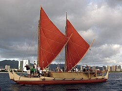
Hōkūleʻa is a performance-accurate waʻa kaulua, a Polynesian double-hulled voyaging canoe. Launched on 8 March 1975 by the Polynesian Voyaging Society, it is best known for its 1976 Hawaiʻi to Tahiti voyage completed with exclusively traditional navigation techniques. The primary goal of the voyage was to explore the anthropological theory of the Asiatic origin of native Oceanic people as the result of purposeful trips through the Pacific, as opposed to passive drifting on currents or sailing from the Americas. DNA analysis supports this theory. A secondary project goal was to have the canoe and voyage "serve as vehicles for the cultural revitalization of Hawaiians and other Polynesians."
The Micronesians or Micronesian peoples are various closely related ethnic groups native to Micronesia, a region of Oceania in the Pacific Ocean. They are a part of the Austronesian ethnolinguistic group, which has an Urheimat in Taiwan.
Taumako is the largest of the Duff Islands, in the nation of Solomon Islands in the Pacific Ocean. This 5.7-kilometre-long (3.5-mile) island has steep sides and rises to a height of 400 metres above sea level. It is composed of basaltic lavas and pyroclastics like the other islands in the Duffs.
Pius "Mau" Piailug was a Micronesian navigator from the Carolinian island of Satawal, best known as a teacher of traditional, non-instrument wayfinding methods for open-ocean voyaging. Mau's Carolinian navigation system, which relies on navigational clues using the Sun and stars, winds and clouds, seas and swells, and birds and fish, was acquired through rote learning passed down through teachings in the oral tradition. He earned the title of master navigator (palu) by the age of eighteen, around the time the first American missionaries arrived in Satawal. As he neared middle age, Mau grew concerned that the practice of navigation in Satawal would disappear as his people became acculturated to Western values. In the hope that the navigational tradition would be preserved for future generations, Mau shared his knowledge with the Polynesian Voyaging Society (PVS). With Mau's help, PVS used experimental archaeology to recreate and test lost Hawaiian navigational techniques on the Hōkūleʻa, a modern reconstruction of a double-hulled Hawaiian voyaging canoe.
Satawal is a solitary coral atoll of one island with about 500 people on just over 1 km2 located in the Caroline Islands in the Pacific Ocean. It forms a legislative district in Yap State in the Federated States of Micronesia. Satawal is the easternmost island in the Yap island group and is located approximately 70 kilometers (43 mi) east of Lamotrek.
David Henry Lewis was a sailor, adventurer, doctor, and scholar of Polynesian culture. He is best known for his studies on the traditional systems of navigation used by the Pacific Islanders. His studies, published in the book We, the Navigators, made these navigational methods known to a wide audience and helped to inspire a revival of traditional voyaging methods in the South Pacific.
Pwo is a sacred initiation ritual, in which students of traditional navigation in the Caroline Islands in Micronesia become navigators (palu) and are initiated in the associated secrets. Many islanders in the area indicate that this ceremony originated on the island of Pollap, or nearby islands.
Weriyeng is one of the last two schools of traditional navigation found in the central Caroline Islands in Micronesia, the other being Fanur. By tradition these two schools were considered to be the most high of all the schools of navigation that once dotted the islands of the central Carolines. By tradition the Weriyeng school was founded on the island of Pulap, which is today in the Pattiw region of Chuuk State, Federated States of Micronesia.
Polynesian navigation or Polynesian wayfinding was used for thousands of years to enable long voyages across thousands of kilometres of the open Pacific Ocean. Polynesians made contact with nearly every island within the vast Polynesian Triangle, using outrigger canoes or double-hulled canoes. The double-hulled canoes were two large hulls, equal in length, and lashed side by side. The space between the paralleled canoes allowed for storage of food, hunting materials, and nets when embarking on long voyages. Polynesian navigators used wayfinding techniques such as the navigation by the stars, and observations of birds, ocean swells, and wind patterns, and relied on a large body of knowledge from oral tradition. This island hopping was a solution to the scarcity of useful resources, such as food, wood, water, and available land, on the small islands in the Pacific Ocean. When an island’s required resources for human survival began to run low, the island's inhabitants used their maritime navigation skills and set sail for new islands. However, as an increasing number of islands in the South Pacific became occupied, and citizenship and national borders became of international importance, this was no longer possible. People thus became trapped on islands with the inability to support them.
The Refaluwasch people are a Micronesian ethnic group who originated in Oceania, in the Caroline Islands, with a total population of over 8,500 people in the Northern Mariana Islands. They are also known as Remathau in the Yap's outer islands. The Carolinian word means "People of the Deep Sea." It is thought that their ancestors may have originally immigrated from Asia and Melanesia to Micronesia around 2,000 years ago. Their primary language is Carolinian, called Refaluwasch by native speakers, which has a total of about 5,700 speakers. The Refaluwasch have a matriarchal society in which respect is a very important factor in their daily lives, especially toward the matriarchs. Most Refaluwasch are of the Roman Catholic faith.
Polynesia is a subregion of Oceania, made up of more than 1,000 islands scattered over the central and southern Pacific Ocean. The indigenous people who inhabit the islands of Polynesia are called Polynesians. They have many things in common, including language relatedness, cultural practices, and traditional beliefs. In centuries past, they had a strong shared tradition of sailing and using stars to navigate at night.
Wa are traditional sailing outrigger canoes of the Caroline Islands, which also includes Palau and Yap. They have a single outrigger. They are similar to the sakman of the Northern Marianas.
Namonabetiu is a group of atolls within the Federated States of Micronesia; it comprises Puluwat, Pulap, Tamatam, and Pulusuk.
We, the Navigators, The Ancient Art of Landfinding in the Pacific is a 1972 book by the British-born New Zealand doctor David Lewis, which explains the principles of Micronesian and Polynesian navigation through his experience of placing his boat under control of several traditional navigators on long ocean voyages.
etak is a word of Micronesian origin for a distinctive cognitive and mnemonic approach to oceanic navigation and orientation involving a notional reference point or "island", called etak, and triangulation based on it. The system under that name was found in the Caroline Islands, and the literal meaning of etak is "refuge". Alfred Gell described it as a way of encoding dead reckoning applied to sea journeys. It is an example of a dynamic cognitive map.
Micronesian navigation techniques are those navigation skills used for thousands of years by the navigators who voyaged between the thousands of small islands in the western Pacific Ocean in the subregion of Oceania, that is commonly known as Micronesia. These voyagers used wayfinding techniques such as the navigation by the stars, and observations of birds, ocean swells, and wind patterns, and relied on a large body of knowledge from oral tradition. These navigation techniques continued to be held by Polynesian navigators and navigators from the Santa Cruz Islands. The re-creations of Polynesian voyaging in the late 20th century used traditional stellar navigational methods that had remained in everyday use in the Caroline Islands.
Then, in 1969, David Lewis visited the Central Carolinian island of Puluwat in his auxiliary ketch, the Isbjorn, while investigating ongoing systems of navigation throughout Oceania. Lewis had heard that the navigators of Puluwat possessed the knowledge to sail the 900-mile round-trip to Saipan, and upon arrival there asked one of the navigators, Hipour, to accompany him on the Isbjorn and navigate the vessel to Saipan and return. It was understood that only the indigenous knowledge that had been taught Hipour by the navigators of Puluwat would be used. The successful completion of this voyage, plus other factors, has led to a renaissance in Carolinian-Marianas voyaging and strengthened ties between Carolinians and their cousins on Saipan.