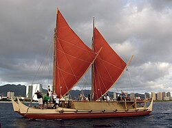
Weriyeng

Last updated

Weriyeng (also spelled Warieng) [1] is one of the last two schools of traditional navigation found in the central Caroline Islands in Micronesia, the other being Fanur. [2] By tradition these two schools were considered to be the most high of all the schools of navigation that once dotted the islands of the central Carolines. By tradition the Weriyeng school was founded on the island of Pulap, which is today in the Pattiw region of Chuuk State, Federated States of Micronesia.

Contents

Mau Piailug is one of the most famous navigators of this school. He trained the well-known modern Hawaiian wayfinder Nainoa Thompson. [3]

Palu (master navigator) in this school

Notes

  1. Gladwin, Thomas (1970). East Is a Big Bird . Cambridge, Massachusetts: Harvard University Press. pp.  200. ISBN   0-674-22425-6.
  2. Woodward, David (1998). History of Cartography. University of Chicago Press. p. 470. ISBN   0-226-90728-7 . Retrieved 2010-08-04.
  3. "Pius "Mau" Piailug". Polynesian Voyaging Society.


Related Research Articles

Federated States of Micronesia Country in the western Pacific

The Federated States of Micronesia is an island country in Oceania associated with the United States. It consists of four states – from west to east, Yap, Chuuk, Pohnpei and Kosrae – that are spread across the western Pacific Ocean. Together, the states comprise around 607 islands that cover a longitudinal distance of almost 2,700 km (1,678 mi) just north of the equator. They lie northeast of New Guinea, south of Guam and the Marianas, west of Nauru and the Marshall Islands, east of Palau and the Philippines, about 2,900 km (1,802 mi) north of eastern Australia, 3,400 km southeast of Japan, and some 4,000 km (2,485 mi) southwest of the main islands of Hawaii.

Micronesia Subregion of Oceania

Micronesia is a subregion of Oceania, composed of thousands of small islands in the western Pacific Ocean. It has a close shared cultural history with three other island regions: the Philippines to the west, Polynesia to the east, and Melanesia to the south; as well as with the wider Austronesian peoples.

Caroline Islands Archipelago

The Caroline Islands are a widely scattered archipelago of tiny islands in the western Pacific Ocean, to the north of New Guinea. Politically they are divided between the Federated States of Micronesia in the eastern part of the group, and Palau at the extreme western end. Historically, this area was also called Nuevas Filipinas or New Philippines as they were part of the Spanish East Indies and governed from Manila in the Philippines.

Pacific Islander Indigenous peoples of the Pacific Islands

Pacific Islanders, or Pasifika, are the peoples of the Pacific Islands. It is a geographic and ethnic/racial term to describe the inhabitants and diaspora of any of the three major sub-regions of Oceania. It is not used to describe non-indigenous inhabitants of the Pacific islands. Pacific Islanders are Austronesian people.

Polynesian Voyaging Society

The Polynesian Voyaging Society (PVS) is a non-profit research and educational corporation based in Honolulu, Hawaiʻi. PVS was established to research and perpetuate traditional Polynesian voyaging methods. Using replicas of traditional double-hulled canoes, PVS undertakes voyages throughout Polynesia navigating without modern instruments.

<i>Hōkūleʻa</i>

Hōkūleʻa is a performance-accurate waʻa kaulua, a Polynesian double-hulled voyaging canoe. Launched on 8 March 1975 by the Polynesian Voyaging Society, she is best known for her 1976 Hawaiʻi to Tahiti voyage completed with exclusively Polynesian navigation techniques The primary goal of the voyage was to explore the anthropological theory of the Asiatic origin of native Oceanic people, of Polynesians and Hawaiians in particular, as the result of purposeful trips through the Pacific, as opposed to passive drifting on currents, or sailing from the Americas. A secondary project goal was to have the canoe and voyage "serve as vehicles for the cultural revitalization of Hawaiians and other Polynesians".

Chuuk Lagoon A sheltered body of water in the central Pacific in the Federated States of Micronesia

Chuuk Lagoon, previously Truk Atoll, is an atoll in the central Pacific. About 1,800 kilometres north-east of New Guinea, it is located mid-ocean at 7 degrees North latitude and is part of Chuuk State within the Federated States of Micronesia (FSM). A protective reef, 225 kilometres (140 mi) around, encloses a natural harbour 79 by 50 kilometres, with an area of 2,130 square kilometres. It has a land area of 93.07 square kilometres, with a population of 36,158 people and a maximal height of 443 m (1,453 ft). Weno city on Moen Island functions as the atoll's capital and also as the state capital and is the largest city in the FSM with its 13,700 people.

Chuuk State State in Federated States of Micronesia

Chuuk State is one of the four states of the Federated States of Micronesia (FSM). The other states are Kosrae State, Pohnpei State, and Yap State. It consists of several island groups:

Mau Piailug Micronesian navigator and navigation teacher

Pius "Mau" Piailug was a Micronesian navigator from the Carolinian island of Satawal, best known as a teacher of traditional, non-instrument wayfinding methods for open-ocean voyaging. Mau's Carolinian navigation system, which relies on navigational clues using the Sun and stars, winds and clouds, seas and swells, and birds and fish, was acquired through rote learning passed down through teachings in the oral tradition. He earned the title of master navigator (palu) by the age of eighteen, around the time the first American missionaries arrived in Satawal. As he neared middle age, Mau grew concerned that the practice of navigation in Satawal would disappear as his people became acculturated to Western values. In the hope that the navigational tradition would be preserved for future generations, Mau shared his knowledge with the Polynesian Voyaging Society (PVS). With Mau's help, PVS used experimental archaeology to recreate and test lost Hawaiian navigational techniques on the Hōkūle‘a, a modern reconstruction of a double-hulled Hawaiian voyaging canoe.

Nainoa Thompson

Charles Nainoa Thompson is a Native Hawaiian navigator and the president of the Polynesian Voyaging Society. He is best known as the first Hawaiian to practice the ancient Polynesian art of navigation since the 14th century, having navigated two double-hulled canoes from Hawaiʻi to other island nations in Polynesia without the aid of western instruments.

Satawal

Satawal is a solitary coral atoll of one island with about 500 people on just over 1 km2 located in the Caroline Islands in the Pacific Ocean It forms a legislative district in Yap State in the Federated States of Micronesia. Satawal is the easternmost island in the Yap island group and is located approximately 70 kilometres (43 mi) east of Lamotrek.

Pwo is a sacred initiation ritual, in which students of traditional navigation in the Caroline Islands in Micronesia become navigators (palu) and are initiated in the associated secrets. Many islanders in the area indicate that this ceremony originated on the island of Pollap, or nearby islands.

Alingano Maisu, also known as Maisu, is a double-hulled voyaging canoe built in Kawaihae, Hawaii by members of Na Kalai Waʻa Moku o Hawaiʻi and ʻOhana Wa'a members from throughout the Pacific and abroad as a gift and tribute to Satawalese navigator Mau Piailug, who navigated the voyaging canoe Hōkūleʻa on her maiden voyage to Tahiti in 1976 and has since trained numerous native Hawaiians in the ancient art of wayfinding. The word maisu comes from the Satawalese word for breadfruit that has been knocked down by storm winds and is therefore available for anyone to take. The name is said to symbolize the knowledge of navigation that is made freely available.

Polynesian navigation Methods to navigate the Pacific ocean

Traditional Polynesian navigation was used for thousands of years to make long voyages across thousands of kilometres of the open Pacific Ocean. Navigators travelled to small inhabited islands using wayfinding techniques and knowledge passed by oral tradition from master to apprentice, often in the form of song. Generally, each island maintained a guild of navigators who had very high status; in times of famine or difficulty, they could trade for aid or evacuate people to neighbouring islands. As of 2014, these traditional navigation methods are still taught in the Polynesian outlier of Taumako in the Solomons.

Ben Rudolph Finney was an American anthropologist known for his expertise in the history and the cultural and social anthropology of surfing, Polynesian navigation, and canoe sailing, as well as in the cultural and social anthropology of human space colonization. As “surfing’s premier historian and leading expert on Hawaiian surfing going back to the 17th century” and “the intellectual mentor, driving force, and international public face” of the Hokulea project, he played a key role in the Hawaiian Renaissance following his construction of the Hokulea precursor Nalehia in the 1960s and his co-founding of the Polynesian Voyaging Society in the 1970s.

Polynesia Subregion of Oceania

Polynesia is a subregion of Oceania, made up of more than 1,000 islands scattered over the central and southern Pacific Ocean. The indigenous people who inhabit the islands of Polynesia are termed Polynesians, sharing many similar traits including language family, culture, and beliefs. Historically, they had a strong tradition of sailing and using stars to navigate at night. The largest country in Polynesia is New Zealand.

Yap Island group in the Federated States of Micronesia

Yap or Wa′ab traditionally refers to an island group located in the Caroline Islands of the western Pacific Ocean, a part of Yap State. The name "Yap" in recent years has come to also refer to the state within the Federated States of Micronesia, inclusive of the Yap Main Islands and its various outer islands. For specifying the island group, the name Yap Main Islands is most exact.

Japanese settlement in what constitutes the present-day Federated States of Micronesia (FSM) dates back to the end of the 19th century, when Japanese traders and explorers settled on the central and eastern Carolines, although earlier contacts can not be completely excluded. After Japan occupied the islands in 1914, Japanese migrated to the Carolines on a large scale in the 1920s and 1930s. The Japanese government encouraged immigration to the islands belonging to the South Seas Mandate in order to offset demographic and economic problems facing Japan at that time.

<i>Wa</i> (watercraft) Type of outrigger canoe from the Caroline Islands

Wa are traditional sailing outrigger canoes of the Caroline Islands. They have a single outrigger. They are similar to the sakman of the Northern Marianas.

Hipour was a master navigator from the navigational school of Weriyeng and the island of Puluwat.