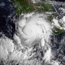
Hurricane John (2006)

Last updated
Map key
  Tropical depression (≤38 mph, ≤62 km/h)
  Tropical storm (39–73 mph, 63–118 km/h)
  Category 1 (74–95 mph, 119–153 km/h)
  Category 2 (96–110 mph, 154–177 km/h)
  Category 3 (111–129 mph, 178–208 km/h)
  Category 4 (130–156 mph, 209–251 km/h)
  Category 5 (≥157 mph, ≥252 km/h)
  Unknown
Storm type
Disc Plain black.svg Tropical cyclone
Solid black.svg Subtropical cyclone
ArrowUp.svg Extratropical cyclone, remnant low, tropical disturbance, or monsoon depression

The tropical wave that would become John moved off the coast of Africa on August 17. It entered the eastern Pacific Ocean on August 24, and quickly showed signs of organization. That night, Dvorak classifications were initiated on the system while it was just west of Costa Rica, [1] and it moved west-northwestward at 10–15 mph (16–24 km/h). [2] Conditions appeared favorable for further development, [3] and convection increased late on August 26 over the area of low pressure. [4] Early on August 27, the system became much better organized about 250 miles (400 km) south-southwest of Guatemala, [5] although convection remained minimal. [6] Early on August 28, banding increased within its organizing convection, and the system developed into Tropical Depression Eleven-E. [7]

Due to low amounts of vertical shear, very warm waters, and abundant moisture, steady intensification was forecast, [7] and the depression strengthened to Tropical Storm John later on August 28. [8] Deep convection continued to develop over the storm, [9] while an eye feature developed within the expanding central dense overcast. [10] The storm continued to intensify, and John attained hurricane status on August 29 while 190 miles (310 km) south-southeast of Acapulco. Banding features continued to increase as the hurricane moved west-northwestward around the southwest periphery of a mid- to upper-level ridge over northern Mexico. [11] The hurricane underwent rapid intensification, and John attained major hurricane status 12 hours after becoming a hurricane. [1] Shortly thereafter, the eye became obscured, and the intensity remained at 115 mph (185 km/h) [12] due to an eyewall replacement cycle. Another eye formed, [13] and based on Reconnaissance data, the hurricane attained Category 4 status on the Saffir-Simpson Hurricane Scale on August 30 about 160 miles (260 km) west of Acapulco, or 95 miles (153 km) south of Lázaro Cárdenas, Michoacán. [14] Hours later, the hurricane underwent another eyewall replacement cycle, [15] and subsequently weakened to Category 3 status as it paralleled the Mexican coastline a short distance offshore. [16]

Hurricane John rapidly intensifying off the coast of Guerrero on August 29 11E John 20060829.jpg
Hurricane John rapidly intensifying off the coast of Guerrero on August 29

Due to land interaction and its eyewall replacement cycle, Hurricane John weakened to a 105 mph (169 km/h) hurricane by late on August 31, [1] but restrengthened to a major hurricane shortly after as its eye became better defined. [17] After completing another eyewall replacement cycle, the hurricane again weakened to Category 2 status, [18] and on September 1, it made landfall on Cabo del Este on the southern tip of Baja California Sur, with winds of 110 mph (180 km/h). [19] John passed near La Paz as a weakening Category 1 hurricane on September 2, [1] and weakened to a tropical storm shortly thereafter over land. [20] John continued to weaken, and late on September 3, the system deteriorated to a tropical depression while still over land. [21] By September 4, most of the convection decoupled from the circulation towards mainland Mexico, and a clear circulation had not been discernible for 24 hours. Based on the disorganization of the system, the National Hurricane Center issued its last advisory on the system. [22]

Preparations

The Mexican army and emergency services were stationed near the coast, while classes at public schools in and around Acapulco were canceled. Officials in Acapulco advised residents in low-lying areas to be on alert, and also urged fishermen to return to harbor. Authorities in the twin resort cities of Ixtapa and Zihuatanejo closed the port to small ocean craft. [23] Government officials in the state of Jalisco declared a mandatory evacuation for 8,000 citizens in low-lying areas to 900 temporary shelters. Temporary shelters were also set up near Acapulco. [24] The state of Michoacán was on a yellow alert, the middle of a five-level alert system. [25] Carnival Cruise Lines diverted the path of one cruise ship traveling along the Pacific waters off Mexico. [26]

On August 31, the Baja California Sur state government ordered the evacuation of more than 10,000 residents. Those who refused to follow the evacuation order would have been forced to evacuate by the army. Shelters were set up to allow local residents and tourists to ride out the storm. [27] Just weeks after a major flood in the area, officials evacuated hundreds of citizens in Las Presas in northern Mexico area near a dam. All public schools in the area were closed, as well. [28]

On September 4, the United States' National Weather Service issued flood watches and warnings for portions of Texas and the southern two-thirds of New Mexico. [29]

Impact

Mexico

Hurricane John approaching Baja California Peninsula on September 1 Hurricane John 01 sept 2006 2055Z.jpg
Hurricane John approaching Baja California Peninsula on September 1

The powerful winds of Hurricane John produced heavy surf and downed trees near Acapulco. The hurricane produced a 10-foot (3.0 m) storm surge in Acapulco that flooded coastal roads. [1] In addition, John caused heavy rainfall along the western coast of Mexico, peaking at 12.5 inches (320 mm) in Los Planes, Jalisco. [1] The rainfall resulted in mudslides in the Costa Chica region of Guerrero, leaving around 70 communities isolated. [30]

In La Paz, capital of Baja California Sur, the hurricane downed 40 power poles. Authorities cut off the power supply to the city to prevent electrocutions from downed wires. Strong winds downed trees and destroyed many advertisement signs. [31] Heavy rainfall totaling more than 20 inches (510 mm) in isolated areas [29] resulted in ankle-deep flooding, closing many roads in addition to the airport in La Paz. [31] In La Paz, 300 families received damage to their homes, with another 200 families left homeless after their houses were destroyed. [32] The combination of winds and rain destroyed thousands of flimsy houses across the region. The rainfall also destroyed large areas of crops, and also killed many livestock. [33] The rainfall caused the Iguagil dam in Comondú to overflow, isolating 15 towns due to 4 feet (1.2 m) floodwaters. [34] In the coastal city of Mulegé, flash flooding caused widespread damage throughout the town and the death of a United States citizen. More than 250 homes were damaged or destroyed in the town, leaving many people homeless. [32] Severe flooding blocked portions of Federal Highway 1, and damaged an aqueduct in the region. [35]

In all, Hurricane John destroyed hundreds of houses and blew off the roofs of 160 houses on the Baja California peninsula. [36] Five people were killed, [1] and damage in Mexico amounted to $663 million (2006  MXN, $60.8 million 2006  USD). [37]

In Ciudad Juárez, Chihuahua, across the U.S. border from El Paso, Texas, rainfall from the storm's remnants flooded 20 neighborhoods, downed power lines, and resulted in several traffic accidents. [29] Rainfall from John, combined with continual precipitation during the two weeks before the storm, left thousands of people homeless. [38]

United States

John's moisture over the Southwestern United States John2006ElPasoRadar.png
John's moisture over the Southwestern United States

Moisture from the remnants of John combined with an approaching cold front to produce moderate amounts of rainfall across the southwest United States, including a total of 8 inches (200 mm) in Whitharral [39] and more than 3 inches (76 mm) in El Paso, Texas. The rainfall flooded many roads in southwestern Texas, [29] including a 12 mile (800 m) portion of Interstate 10 in El Paso. [40] A slick runway at El Paso International Airport delayed a Continental Airlines jet when its tires were stuck in mud. [29] Rainfall from John in El Paso, combined with an unusually wet year, resulted in twice the normal annual rainfall, and caused 2006 to be the ninth wettest year on record by September. [41] Damage totaled about $100,000 (2006 USD) in the El Paso area from the precipitation. [42] In northern Texas, the rainfall alleviated a severe drought, [28] caused the Double Mountain Fork Brazos River to swell and Lake Alan Henry to overflow. [43] The Texas Department of Transportation closed numerous roads due to flooding from the precipitation, including a portion of U.S. Route 385 near Levelland. Several other roads were washed out. [39]

Moisture derived from John also produced rainfall across southern New Mexico, peaking at 5.25 inches (133 mm) at Ruidoso. The rainfall overflowed rivers, forcing people to evacuate along the Rio Ruidoso. [44] The rainfall also caused isolated road flooding. [29] Rainfall in New Mexico canceled an annual wine festival in Las Cruces and caused muddy conditions at the All American Futurity at the Ruidoso Downs, the biggest day of horse racing in New Mexico. [45] Flooding was severe in Mesquite, Hatch, and Rincon, where many homes experienced 4 feet (1.2 m) of flooding and mud. [46] Some homeowners lost all they owned. [47] Tropical moisture from the storm also produced rainfall in Arizona [29] and Southern California. In California, the rainfall produced eight separate mudslides, trapping 19 vehicles, but caused no injuries. [48]

Aftermath

Branches of the Mexican Red Cross in Guerrero, Oaxaca and Michoacán were put on alert. The organization's national emergency response team was on stand-by to assist the most affected areas. [30] Navy helicopters delivered food and water to remote areas of the Baja California peninsula. [33] The Mexican Red Cross dispatched 2,000 food parcels to the southern tip of Baja California Sur. [49] In the city of Mulegé, gas supply, which was necessary to run generators, was low, drinking water was gone, and the airstrip was covered with mud. Many homeless residents initially stayed with friends or in government-run shelters. [32] Throughout the Baja California peninsula, thousands remained without water or electricity two days after the storm, [35] although a pilot from Phoenix prepared to fly to the disaster area with 100 gallons (380 litres) of water. Other pilots were expected to execute similar flights, as well. [32] The office of Baja California Sur Tourism stated that minimal damage occurred to the tourism infrastructure, with only minimal delays to airports, roads, and maritime facilities. [50] The Episcopal Relief and Development delivered food, clothing, medicine, and transportation to about 100 families, and gave mattresses to about 80 families. [38]

Many residents in Tucson, including more than 50 students, delivered supplies to flood victims in New Mexico, including clothing and other donations. [47]

See also

Related Research Articles

<span class="mw-page-title-main">Hurricane Juliette (2001)</span> Category 4 Pacific hurricane in 2001

Hurricane Juliette was a long-lasting Category 4 hurricane in the 2001 Pacific hurricane season. It caused 12 deaths and $400 million in damage when it hit Baja California in late September. Juliette developed from a tropical wave that had previously produced a tropical depression. The wave moved from the Atlantic to the Eastern Pacific, where it started to intensify. Soon, it became a tropical storm and was named Juliette. It then became a hurricane two days later, after struggling to do so. Rapidly intensifying due to favourable conditions, Juliette reached Category 4 status. However, an eyewall replacement cycle caused Juliette to significantly weaken down to a Category 2 hurricane. It eventually completed the cycle, and Juliette was able to reintensify to its peak intensity of 145 mph and 923 milibars. Another eyewall replacement cycle ensued however, resulting in Juliette having 3 eyewalls at once, which is an extremely rare occurrence. Eventually, Juliette weakened to a tropical storm, but Juliette's circulation was still well-defined. Warm waters allowed it to re-intensify to a hurricane, but this was short-lived as Juliette meandered near Baja California and its center became difficult to locate. It made landfall on Baja California as a tropical storm. Its circulation reached the Gulf of California, where it restrengthened slightly. Juliette made landfall on Baja California and dissipated on October 3.

<span class="mw-page-title-main">Tropical Storm Chris (2006)</span> Atlantic tropical storm in 2006

Tropical Storm Chris was the fourth tropical storm of the 2006 Atlantic hurricane season. Forming on July 31 in the Atlantic Ocean east of the Leeward Islands from a tropical wave, Chris moved generally to the west-northwest, skirting the northern fringes of the Caribbean islands. Chris was a relatively short-lived storm, reaching a peak intensity with winds at 65 mph (105 km/h) on August 2, while positioned north of St. Martin. The storm gradually weakened before finally dissipating on August 5, near eastern Cuba. Overall impact was minimal, amounting to moderate amounts of rainfall throughout its path. No deaths were reported.
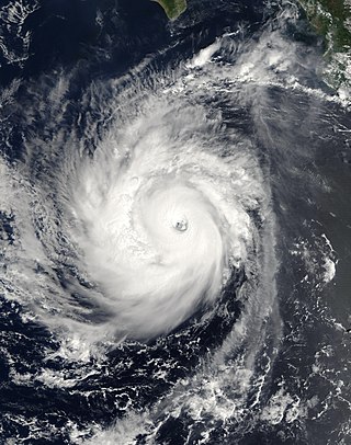
<span class="mw-page-title-main">Hurricane Lane (2006)</span> Category 3 Pacific hurricane in 2006

Hurricane Lane was the strongest Pacific hurricane to make landfall in Mexico since Hurricane Kenna of 2002. The thirteenth named storm, ninth hurricane, and sixth major hurricane of the 2006 Pacific hurricane season, Lane developed on September 13 from a tropical wave to the south of Mexico. It moved northwestward, parallel to the coast of Mexico, and steadily intensified in an area conducive to further strengthening. After turning to the northeast, Lane attained peak winds of 125 mph (201 km/h), and made landfall in the state of Sinaloa at peak strength. It rapidly weakened and dissipated on September 17, and later brought precipitation to southern part of the U.S. state of Texas.

<span class="mw-page-title-main">Hurricane Paul (2006)</span> Category 2 Pacific hurricane in 2006

Hurricane Paul was a hurricane that ultimately struck Mexico as a tropical depression in October 2006. It developed from an area of disturbed weather on October 21, and slowly intensified as it moved into an area of warm waters and progressively decreasing wind shear. Paul attained hurricane status on October 23, and later that day it reached its peak intensity of 105 mph (169 km/h), a strong Category 2 hurricane on the Saffir-Simpson scale. A strong trough turned the hurricane to the north and northeast into an area of strong vertical shear, and Paul weakened to a tropical storm on October 24. It accelerated northeastward, and after passing a short distance south of Baja California Sur the low level circulation became decoupled from the rest of the convection. Paul weakened to a tropical depression on October 25 a short distance off the coast of Mexico, and after briefly turning away from the coast it made landfall on northwestern Sinaloa on October 26.

<span class="mw-page-title-main">Tropical Storm Emilia (2006)</span> Pacific tropical storm in 2006

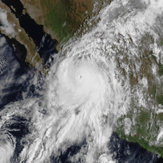
Tropical Storm Emilia was a rare tropical cyclone that affected the Baja California Peninsula in July 2006. The sixth tropical depression and fifth tropical storm of the 2006 Pacific hurricane season, it developed on July 21 about 400 miles (640 km) off the coast of Mexico. It moved northward toward the coast, reaching peak winds of 65 mph (105 km/h) before turning westward and encountering unfavorable conditions. Emilia later turned to the north, passing near Baja California as a strong tropical storm. Subsequently, the storm moved further away from the coast, and on July 27 it dissipated.

<span class="mw-page-title-main">2011 Pacific hurricane season</span> Hurricane season in the Pacific Ocean

The 2011 Pacific hurricane season was a below average season in terms of named storms, although it had an above average number of hurricanes and major hurricanes. During the season, 13 tropical depressions formed along with 11 tropical storms, 10 hurricanes and 6 major hurricanes. The season officially began on May 15 in the East Pacific Ocean, and on June 1 in the Central Pacific; they both ended on November 30. These dates conventionally delimit the period of each year when most tropical cyclones form in the Pacific basin. The season's first cyclone, Hurricane Adrian formed on June 7, and the last, Hurricane Kenneth, dissipated on November 25.

<span class="mw-page-title-main">Hurricane Madeline (1998)</span> Category 1 Pacific hurricane in 1998

Hurricane Madeline was a costly tropical cyclone whose remnants caused hundreds of millions of dollars in damage in Texas in October 1998. The final tropical cyclone of the 1998 Pacific hurricane season, Madeline originated from a tropical wave that emerged off the coast of Africa on September 25, 1998. The wave traversed the Atlantic Ocean and crossed over Central America on October 5 or 6. Gradually, the system intensified and was classified as a tropical depression on October 16, a tropical storm later that day, and a hurricane on October 17. The storm reached peak winds of 85 mph (137 km/h) about 95 miles (153 km) southwest of San Blas, Nayarit, and after 18 hours it subsequently began to weaken. Although Madeline never made landfall, numerous rainbands affected the Mexican coast causing no known damage or fatalities. The remnant moisture moved north and contributed to flooding in central Texas, which killed 31 people and caused $750 million in damage.

<span class="mw-page-title-main">Tropical Storm Norman (2006)</span> Pacific tropical storm in 2006

Tropical Storm Norman was a weak tropical cyclone that brought heavy rainfall to southwestern Mexico in October 2006. The fifteenth named storm of the 2006 Pacific hurricane season, Norman developed on October 9 from a tropical wave well to the southwest of Mexico. Unfavorable conditions quickly encountered the system, and within two days of forming, Norman dissipated as its remnants turned to the east. Thunderstorms gradually increased again, as it interacted with a disturbance to its east, and on October 15 the cyclone regenerated just off the coast of Mexico. The center became disorganized and quickly dissipated, bringing a large area of moisture which dropped up to 6 inches (150 mm) of rainfall to southwestern Mexico. Rainfall from the storm flooded about 150 houses, of which 20 were destroyed. One person was injured, and initially there were reports of two people missing due to the storm; however, it was not later confirmed.

<span class="mw-page-title-main">Tropical Storm Julio (2008)</span> Pacific tropical storm in 2008

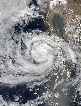
Tropical Storm Julio was a tropical storm that made landfall on the southern tip of Baja California Sur in August 2008. The tenth named storm of the 2008 Pacific hurricane season, it developed from a tropical wave on August 23 off the coast of Mexico. It moved parallel to the coast, reaching peak winds of 50 mph (85 km/h) before moving ashore and weakening. On August 26 it dissipated in the Gulf of California. Julio was the third tropical cyclone to make landfall in the Pacific Ocean basin during the season, after Tropical Storm Alma, which struck Nicaragua in May, and Tropical Depression Five-E, which moved ashore along southwestern Mexico in July. The storm brought locally heavy rainfall to southern Baja California, killing one person and leaving several towns isolated. Moisture from Julio reached Arizona, producing thunderstorms, including one which damaged ten small planes in Chandler.

<span class="mw-page-title-main">2006 Pacific hurricane season</span> Hurricane season in the Pacific Ocean

The 2006 Pacific hurricane season was the first above-average season since 1997 which produced twenty-five tropical cyclones, with nineteen named storms, though most were rather weak and short-lived. Only eleven hurricanes formed and six major hurricanes. Following the inactivity of the previous seasons, forecasters predicted that season would be only slightly above active. It was also the first time since 2003 in which at least one cyclone of tropical storm intensity made landfall. The season officially began on May 15 in the East Pacific Ocean, and on June 1 in the Central Pacific; they ended on November 30. These dates conventionally delimit the period of each year when most tropical cyclones form in the Pacific basin. However, the formation of tropical cyclones is possible at any time of the year.

<span class="mw-page-title-main">Hurricane Hernan (1996)</span> Category 1 Pacific hurricane in 1996

Hurricane Hernan was fourth and final tropical cyclone to strike Mexico at hurricane intensity during the 1996 Pacific hurricane season. The thirteenth tropical cyclone, eighth named storm, and fifth hurricane of the season, Hernan developed as a tropical depression from a tropical wave to the south of Mexico on September 30. The depression quickly strengthened, and became Tropical Storm Hernan later that day. Hernan curved north-northwestward the following day, before eventually turning north-northeastward. Still offshore of the Mexican coast on October 2, Hernan intensified into a hurricane. Six hours later, Hernan attained its peak as an 85 mph (140 km/h) Category 1 hurricane on the Saffir-Simpson Hurricane Wind Scale (SSHWS). After weakening somewhat, on 1000 UTC October 3, Hurricane Hernan made landfall near Barra de Navidad, Jalisco, with winds of 75 mph (120 km/h). Only two hours after landfall, Hernan weakened to a tropical storm. By October 4, Tropical Storm Hernan had weakened into a tropical depression, and dissipated over Nayarit on the following day.

<span class="mw-page-title-main">Hurricane Norbert (2008)</span> Category 4 Pacific hurricane in 2008

Hurricane Norbert is tied with Hurricane Jimena as the strongest tropical cyclone to strike the west coast of Baja California Sur in recorded history. The fifteenth named storm, seventh hurricane, and second major hurricane of the 2008 hurricane season, Norbert originated as a tropical depression from a tropical wave south of Acapulco on October 3. Strong wind shear initially prevented much development, but the cyclone encountered a more favorable environment as it moved westward. On October 5, the National Hurricane Center (NHC) upgraded the depression to Tropical Storm Norbert, and the system intensified further to attain hurricane intensity by October 6. After undergoing a period of rapid deepening, Norbert reached its peak intensity as a Category 4 on the Saffir–Simpson hurricane wind scale, with maximum sustained winds of 135 mph (217 km/h) and a minimum barometric pressure of 945 mbar. As the cyclone rounded the western periphery of a subtropical ridge over Mexico, it began an eyewall replacement cycle which led to steady weakening. Completing this cycle and briefly reintensifying into a major hurricane, a Category 3 or higher on the Saffir–Simpson hurricane wind scale, Norbert moved ashore Baja California Sur as a Category 2 hurricane late on October 11. After a second landfall at a weaker intensity the following day, the system quickly weakened over land and dissipated that afternoon.
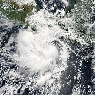
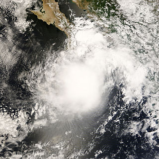
<span class="mw-page-title-main">2009 Pacific hurricane season</span> Hurricane season in the Pacific Ocean

The 2009 Pacific hurricane season was the most active Pacific hurricane season since 1997. The season officially started on May 15 in the East Pacific Ocean, and on June 1 in the Central Pacific; they both ended on November 30. These dates conventionally delimit the period of each year when most tropical cyclones form in the Pacific basin. The first tropical cyclone to form was One-E on June 18, and the last, Hurricane Neki, dissipated on October 27.

<span class="mw-page-title-main">Hurricane Howard (2004)</span> Category 4 Pacific hurricane in 2004

Hurricane Howard was a powerful Category 4 hurricane which produced large swells along the coasts of the Baja California Peninsula and southern California. The cyclone was the eighth named storm, fourth hurricane, and second major hurricane of the 2004 Pacific hurricane season. Howard originated out of a tropical wave off the coast of Mexico on August 30. Traveling towards the northwest, the storm gradually strengthened, becoming a hurricane on September 1 and reaching its peak intensity the following day with winds of 140 mph (220 km/h). Decreasing sea surface temperatures then caused the storm to weaken. By September 4, Howard was downgraded to a tropical storm. The next day, it degenerated into a non-convective remnant low-pressure area which persisted for another five days before dissipating over open waters.

<span class="mw-page-title-main">Tropical Storm Carlos (2003)</span> Pacific tropical storm in 2003

Tropical Storm Carlos was the first of five tropical cyclones to make landfall during the 2003 Pacific hurricane season. It formed on June 26 from a tropical wave to the south of Mexico. It quickly strengthened as it approached the coast, and early on June 27 Carlos moved ashore in Oaxaca with winds of 65 mph (105 km/h). The storm rapidly deteriorated to a remnant low, which persisted until dissipating on June 29. Carlos brought heavy rainfall to portions of southern Mexico, peaking at 337 mm (13.3 in) in two locations in Guerrero. Throughout its path, the storm damaged about 30,000 houses, with a monetary damage total of 86.7 million pesos. At least nine people were killed throughout the country, seven due to mudslides and two from river flooding; there was also a report of two missing fishermen.

<span class="mw-page-title-main">Hurricane Rick (2009)</span> Category 5 Pacific hurricane in 2009

Hurricane Rick was the third-most intense Pacific hurricane on record and the second-most intense tropical cyclone worldwide in 2009, only behind Typhoon Nida. Developing off the southern coast of Mexico on October 15, Rick traversed an area with favorable environmental conditions, favoring rapid intensification, allowing it to become a hurricane within 24 hours of being declared a tropical depression. An eye began to form during the afternoon of October 16; once fully formed, the storm underwent another period of rapid strengthening. During the afternoon of October 17, the storm attained Category 5 status on the Saffir–Simpson hurricane wind scale. Several hours later, Rick attained its peak intensity as the third-strongest Pacific hurricane on record with winds of 180 mph (290 km/h) and a barometric pressure of 906 mbar.

<span class="mw-page-title-main">Hurricane Odile</span> Category 4 Pacific hurricane in 2014

Hurricane Odile is tied for the most intense landfalling tropical cyclone in the Baja California Peninsula during the satellite era. Sweeping across the peninsula in September 2014, Odile inflicted widespread damage, particularly in the state of Baja California Sur, in addition to causing lesser impacts on the Mexican mainland and Southwestern United States. The precursor to Odile developed into a tropical depression south of Mexico on September 10 and quickly reached tropical storm strength. After meandering for several days, Odile began to track northwestward, intensifying to hurricane status before rapidly reaching its Category 4 hurricane peak intensity on September 14. The cyclone slightly weakened before making landfall near Cabo San Lucas with winds of 125 mph (205 km/h). Odile gradually weakened as it tracked across the length of the Baja California Peninsula, briefly crossing into the Gulf of California before degenerating into a remnant system on September 17. These remnants tracked northeastward across the Southwestern United States before they were no longer identifiable on September 19.

<span class="mw-page-title-main">2021 Pacific hurricane season</span> Hurricane season in the Pacific Ocean

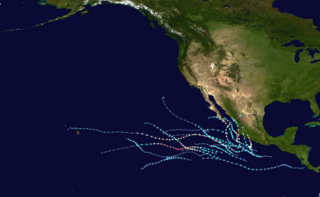
The 2021 Pacific hurricane season was a moderately active Pacific hurricane season, with above-average activity in terms of number of named storms, but below-average activity in terms of major hurricanes, with 17 named storms, 8 hurricanes, and 2 major hurricanes forming in all. It also had a near-normal accumulated cyclone energy (ACE). The season officially began on May 15, 2021 in the Eastern Pacific Ocean, and on June 1, 2021, in the Central Pacific in the Northern Hemisphere. The season ended in both regions on November 30, 2021. These dates historically describe the period each year when most tropical cyclogenesis occurs in these regions of the Pacific and are adopted by convention. However, the formation of tropical cyclones is possible at any time of the year, as illustrated by the formation of Tropical Storm Andres on May 9, which was the earliest forming tropical storm on record in the Eastern Pacific. Conversely, 2021 was the second consecutive season in which no tropical cyclones formed in the Central Pacific.

<span class="mw-page-title-main">Hurricane Dolores (2015)</span> Category 4 Pacific hurricane in 2015

Hurricane Dolores was a powerful and moderately damaging tropical cyclone whose remnants brought record-breaking heavy rains and strong winds to California. The seventh named storm, fourth hurricane, and third major hurricane of the record-breaking 2015 Pacific hurricane season, Dolores formed from a tropical wave on July 11. The system gradually strengthened, attaining hurricane status on July 13. Dolores rapidly intensified as it neared the Baja California peninsula, finally peaking as a Category 4 hurricane on the Saffir–Simpson scale with winds of 130 mph (215 km/h) on July 15. An eyewall replacement cycle began and cooler sea-surface temperatures rapidly weakened the hurricane, and Dolores weakened to a tropical storm two days later. On July 18, Dolores degenerated into a remnant low west of the Baja California peninsula.

<span class="mw-page-title-main">Hurricane Genevieve (2020)</span> Category 4 Pacific hurricane in 2020

Hurricane Genevieve was a strong tropical cyclone that almost made landfall on the Baja California Peninsula in August 2020. The twelfth tropical cyclone, seventh named storm, third hurricane, and second major hurricane of the 2020 Pacific hurricane season, Genevieve formed from a tropical wave that the National Hurricane Center (NHC) first started monitoring on August 10. The wave merged with a trough of low pressure on August 13, and favorable conditions allowed the wave to intensify into Tropical Depression Twelve-E at 15:00 UTC. Just six hours later, the depression became a tropical storm and was given the name Genevieve. Genevieve quickly became a hurricane by August 17, and Genevieve began explosive intensification the next day. By 12:00 UTC on August 18, Genevieve reached its peak intensity as a Category 4 hurricane, with maximum 1-minute sustained winds of 130 mph and a minimum central pressure of 950 millibars (28 inHg). Genevieve began to weaken on the next day, possibly due to cooler waters caused by Hurricane Elida earlier that month. Genevieve weakened below tropical storm status around 18:00 UTC on August 20, as it passed close to Baja California Sur. Soon afterward, Genevieve began to lose its deep convection and became a post-tropical cyclone by 21:00 UTC on August 21, eventually dissipating off the coast of Southern California late on August 24.

References

  1. 1 2 3 4 5 6 7 Richard J. Pasch (2006). "Hurricane John Tropical Cyclone Report" (PDF). National Hurricane Center. Retrieved 2006-11-15.
  2. Roberts/Beven (2006). "August 26 Tropical Weather Outlook". NHC. Retrieved 2006-08-30.[ permanent dead link ]
  3. Mainelli/Knabb (2006). "August 26 Tropical Weather Outlook (2)". NHC. Retrieved 2006-08-30.[ permanent dead link ]
  4. Blake/Stewart (2006). "August 26 Tropical Weather Outlook (3)". NHC. Retrieved 2006-08-30.[ permanent dead link ]
  5. Roberts/Pasch (2006). "August 27 Tropical Weather Outlook". NHC. Retrieved 2006-08-30.[ permanent dead link ]
  6. Blake/Rhome/Franklin (2006). "August 27 Tropical Weather Outlook (2)". NHC. Retrieved 2006-08-30.[ permanent dead link ]
  7. 1 2 Pasch/Landsea (2006). "Tropical Depression Eleven-E Discussion One". NHC. Retrieved 2006-08-30.
  8. Pasch/Landsea (2006). "Tropical Storm John Discussion Two". NHC. Retrieved 2006-08-30.
  9. Rhome/Franklin (2006). "Tropical Storm John Discussion Three". NHC. Retrieved 2006-08-30.
  10. Brown/Stewart (2006). "Tropical Storm John Discussion Four". NHC. Retrieved 2006-08-30.
  11. Mainelli/Pasch (2006). "Hurricane John Discussion Five". NHC. Retrieved 2006-08-30.
  12. Rhome/Franklin (2006). "Hurricane John Discussion Seven". NHC. Retrieved 2006-08-30.
  13. Brown/Stewart (2006). "Hurricane John Discussion Eight". NHC. Retrieved 2006-08-30.
  14. Mainelli/Franklin (2006). "Hurricane John Discussion Nine". NHC. Retrieved 2006-08-30.
  15. Mainelli/Pasch (2006). "Hurricane John Discussion Ten" . Retrieved 2006-08-30.
  16. Rhome/Beven (2006). "Hurricane John Discussion Eleven". NHC. Retrieved 2006-08-30.
  17. Brown/Knabb (2006). "Hurricane John Discussion Sixteen" . Retrieved 2006-09-01.
  18. Blake/Avila (2006). "Hurricane John Discussion Eighteen". NHC. Retrieved 2006-09-01.
  19. Beven (2006). "Hurricane John Discussion Nineteen". NHC. Retrieved 2006-09-01.
  20. Blake/Avila (2006). "Tropical Storm John Discussion 22". NHC. Retrieved 2006-09-02.
  21. Roberts/Pasch (2006). "Tropical Depression John Public Advisory 26A". NHC. Retrieved 2006-09-03.
  22. Franklin (2006). "Tropical Depression John Discussion 29". NHC. Retrieved 2006-09-04.
  23. "Hurricane John grows to a Category 4 storm along Mexico's Pacific coast". Deseret News. Associated Press. 2006-08-30. Archived from the original on 2015-09-24. Retrieved 2007-01-20.
  24. "Hurricane John Weakens To Category 3". CBS News. Associated Press. 2006-08-31. Retrieved 2007-01-20.
  25. Margot Habiby (2006-08-30). "Hurricane John Strengthens Off Mexico's Pacific Coast". Bloomberg. Archived from the original on 2007-06-13. Retrieved 2007-01-20.
  26. Melissa Baldwin (2006-08-30). "Hurricane John Threatens Mexican Riviera". Cruise Critic News. Retrieved 2007-01-20.
  27. Daniel Aguilar (2006). "Mexico orders evacuations as Hurricane John nears". Reuters. Retrieved 2006-08-31.
  28. 1 2 Steve Quinn (2006). "Remnants of Hurricane John douse El Paso". Associated Press. Retrieved 2006-09-04.[ dead link ]
  29. 1 2 3 4 5 6 7 "Hurricane John's remnants soak southern Texas and New Mexico, flooding roads as storm weakens". Associated Press. 2006-09-05. Archived from the original on 2013-02-10. Retrieved 2010-05-02.
  30. 1 2 International Federation of Red Cross And Red Crescent Societies (2006-08-30). "Mexico: Hurricane John Information Bulletin No. 1". ReliefWeb. Archived from the original on 2006-09-05. Retrieved 2007-01-20.
  31. 1 2 Antonio Alcantar (2006). "Hurricane John whips Mexico's Baja, power cut". Reuters. Retrieved 2006-09-02.
  32. 1 2 3 4 Sandra Dibble (2006). "200 families say homes destroyed by flooding". San Diego Union-Tribune. Archived from the original on 2008-11-21. Retrieved 2006-09-08.
  33. 1 2 Malaysian Sun (2006). "Remnants of John could soak U.S. southwest". Archived from the original on 2011-07-19. Retrieved 2006-09-05.
  34. Agence France-Presse (2006). "Hurricane John leaves four dead, two missing in Mexico". Archived from the original on 2006-09-05. Retrieved 2006-09-05.
  35. 1 2 Sandra Dibble (2006). "Baja towns still without utilities after tropical storm; three dead". San Diego Union-Tribune. Archived from the original on 2013-02-02. Retrieved 2006-09-08.
  36. "Hurricane Lane roars toward Baja". USA Today. Associated Press. 2006-09-16. Retrieved 2008-01-13.
  37. Fabiola Martinez (2006). "Seis muertos y 2 desaparecidos por las lluvias en Durango y Tamaulipas" (in Spanish). Retrieved 2006-09-23.
  38. 1 2 Episcopal Relief and Development (2006). "ERD assists people affected by disasters in Mexico, Brazil and Ecuador". Archived from the original on 2012-12-12. Retrieved 2006-09-14.
  39. 1 2 National Climatic Data Center (2006). "Event Report for Texas". Archived from the original on May 19, 2011. Retrieved 2007-01-20.
  40. "After-Effects of Hurricane John Soak Texas, New Mexico". Fox News. Associated Press. 2006-09-04. Archived from the original on 2012-10-14. Retrieved 2006-09-06.
  41. Alicia A. Caldwell (2006). "Continued rain soaks El Paso, nears record levels". Associated Press. Retrieved 2008-01-13.
  42. National Climatic Data Center (2006). "Event Report for Texas (2)". Archived from the original on May 19, 2011. Retrieved 2007-01-20.
  43. Lubbolk, TX National Weather Service (2006). "Labor Day Weekend is a wet one" . Retrieved 2006-09-12.
  44. Albuquerque National Weather Service (2006). "A wet start to September 2006". Archived from the original on October 6, 2008. Retrieved 2006-09-12.
  45. "Hurricane John's remnants soak Texas, New Mexico". Associated Press. 2006. Archived from the original on September 27, 2007. Retrieved 2006-09-06.
  46. Church World Service (2006). "Emergency Appeal: 2006 Summer Storms". Archived from the original on 2012-12-12. Retrieved 2006-09-08.
  47. 1 2 David Marion (2006). "Tucsonans aid New Mexico flood victims". KVOA Tucson. Archived from the original on 2007-09-27. Retrieved 2006-09-06.
  48. "Hurricane leftovers cause minor flooding". Associated Press. 2006. Retrieved 2006-09-05.
  49. International Federation of Red Cross And Red Crescent Societies (2006). "Mexico: Hurricane John Information Bulletin". Archived from the original on 2012-12-12. Retrieved 2006-09-05.
  50. Baja California Sur (2006). "Baja California Sur Tourism Infrastructure Fully Operational After Hurricane John". Archived from the original on 2014-05-06. Retrieved 2006-09-08.
Hurricane John
John 2006-08-30 1415Z.png
Hurricane John at peak intensity off the coast of Mexico, on August 30