
Beekman is a town in Dutchess County, New York, United States. It is part of the Poughkeepsie–Newburgh–Middletown, NY Metropolitan Statistical Area as well as the larger New York–Newark–Bridgeport, NY-NJ-CT-PA Combined Statistical Area. The population was 14,621 at the 2010 census. The town was named after Henry Beekman, a 17th-century land owner.
East Fishkill is a town on the southern border of Dutchess County, New York, United States. The population was 29,029 at the 2010 census. The town was once the eastern portion of the town of Fishkill.

Wappinger, officially the Town of Wappinger, is a town in Dutchess County, New York, United States. The town is located in the Hudson River Valley region, approximately 55 miles (89 km) north of Midtown Manhattan, on the eastern bank of the Hudson River. The population was 27,048 at the 2010 census. The name is derived from the Wappinger Native Americans who inhabited the area. Wappinger comprises three-fourths of the incorporated Village of Wappingers Falls, several unincorporated hamlets such as Chelsea, Diddell, Hughsonville, Middlebush, Myers Corners, New Hackensack, and Swartwoutville, and a number of neighborhoods.

Fishkill is a village within the town of Fishkill in Dutchess County, New York, United States. The village population was 2,171 at the 2010 census. It is part of the Poughkeepsie–Newburgh–Middletown, NY Metropolitan Statistical Area as well as the larger New York–Newark–Bridgeport, NY-NJ-CT-PA Combined Statistical Area.

Fishkill is a town in the southwest part of Dutchess County, New York, United States. It lies approximately 60 miles (97 km) north of New York City. The population was 22,107 at the 2010 census. Fishkill surrounds the city of Beacon.
New York State Route 376 (NY 376) is a state highway located entirely within Dutchess County in the Hudson Valley region of New York in the United States. The route begins at an intersection with NY 52 in East Fishkill and passes north through Hopewell Junction and Red Oaks Mill on its way to the city of Poughkeepsie. It ends at a junction with U.S. Route 44 (US 44) and NY 55 east of the city limits in Arlington, a hamlet in the town of Poughkeepsie. NY 376 was originally designated as part of NY 39 in the mid-1920s. In the 1930 renumbering of state highways in New York, the East Fishkill–Poughkeepsie portion of NY 39 was renumbered to New York State Route 202. NY 202 was renumbered to NY 376 in 1935 to avoid numerical duplication with the new US 202.

Esopus Creek is a 65.4-mile-long (105.3 km) tributary of the Hudson River that drains the east-central Catskill Mountains in the U.S. state of New York. From its source at Winnisook Lake on the slopes of Slide Mountain, the Catskills' highest peak, it flows across Ulster County to the Hudson at Saugerties. Many tributaries extend its watershed into neighboring Greene County and a small portion of Delaware County. Midway along its length, it is impounded at Olive Bridge to create Ashokan Reservoir, the first of several built in the Catskills as part of New York City's water supply system. Its own flow is supplemented 13 miles (21 km) above the reservoir by the Shandaken Tunnel, which carries water from the city's Schoharie Reservoir into the creek.

Fishkill Creek is a tributary of the Hudson River in Dutchess County, New York, United States. At 33.5 miles (53.9 km) it is the second longest stream in the county, after Wappinger Creek. It rises in the town of Union Vale and flows generally southwest to a small estuary on the Hudson just south of Beacon. Part of its 193-square-mile (500 km2) watershed is in Putnam County to the south. Sprout Creek, the county's third-longest creek, is its most significant tributary. Whaley and Sylvan lakes and Beacon Reservoir, its largest, deepest and highest lakes, are among the bodies of water within the watershed.

Wappinger Creek is a 41.7-mile-long (67.1 km) creek which runs from Thompson Pond to the Hudson River at New Hamburg in Dutchess County, New York, United States. It is the longest creek in Dutchess County, with the largest watershed in the county.

Verbank is a hamlet in the town of Union Vale in Dutchess County, New York, United States. Verbank is served by a post office with the ZIP code of 12585; the ZCTA for ZIP Code 12585 had a population of 956 at the 2000 census.
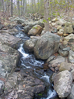
Sprout Creek is a 24.8-mile-long (39.9 km) creek located entirely within Dutchess County, New York, United States. It is the largest tributary of Fishkill Creek, entering that creek some 11 miles (18 km) upstream from the Hudson River. The creek is annually stocked with 6,000 brown trout, and maintains its own natural population of trout.
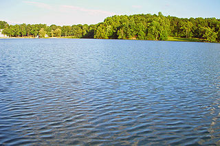
Sylvan Lake is located next to the community by that name in the Town of Beekman, New York, United States. It is the deepest and second-largest lake in Dutchess County.

Coyote Creek is a principal tributary of the San Gabriel River in northwest Orange County, southeast Los Angeles County, and southwest Riverside County, California. It drains a land area of roughly 41.3 square miles (107 km2) covering five major cities, including Brea, Buena Park, Fullerton, La Habra, and La Palma. Some major tributaries of the creek in the highly urbanized watershed include Brea Creek, Fullerton Creek, and Carbon Creek. The mostly flat creek basin is separated by a series of low mountains, and is bounded by several small mountain ranges, including the Chino Hills, Puente Hills and West Coyote Hills.

The Casperkill is a creek in both the town and city of Poughkeepsie, Dutchess County, New York. It flows 11.6 miles (18.7 km) from Peach Hill Park to the Hudson River. Combined with its only major tributary, the Fonteyn Kill, it forms a 12 sq mi (31 km2) subwatershed. It lies entirely within the British royal grant of 1685 known as the Rombout Patent.

The East Branch Croton River is a tributary of the Croton River in Dutchess, Putnam, and Westchester counties in the state of New York. It lies within the Croton River watershed and is part of the New York City water supply system's Croton Watershed.
Trout Creek is a 51-mile (82 km) long tributary of the Deschutes River in the U.S. state of Oregon. It drains approximately 692 square miles (1,792 km2) of Crook, Jefferson, and Wasco counties. Arising in the Ochoco Mountains, it flows north and then west to its confluence with the Deschutes River.

Schwaben Creek is a tributary of Mahanoy Creek in Northumberland County, Pennsylvania, in the United States. Schwaben Creek is approximately 12.4 miles (20.0 km) long. The creek has two named tributaries, which both join Schwaben Creek fairly close to its mouth. The tributaries are called Middle Creek and Mouse Creek. Schwaben Creek flows through Upper Mahanoy Township, Washington Township, and Jackson Township. Nearly all of the creek's watershed is devoted to agricultural land and forests, although there is some development. Painted furniture also was made in the Schwaben Creek valley in the 18th and 19th centuries. The creek is in the ridge-and-valley geographical province.

The Pocantico River is a nine-mile-long (14 km) tributary of the Hudson River in western central Westchester County, New York, United States. It rises from Echo Lake, in the town of New Castle south of the hamlet of Millwood, and flows generally southwest past Briarcliff Manor to its outlet at Sleepy Hollow. Portions of the towns of Mount Pleasant and Ossining are within its 16-square-mile (41 km2) watershed.
Breakneck Brook, sometimes Breakneck Valley Brook, is a 1.7-mile-long (2.8 km) tributary of the Hudson River located entirely in the Putnam County town of Philipstown, New York, United States. It rises at Surprise Lake and flows southwest towards the Hudson from there, mostly through Hudson Highlands State Park. The name comes from Breakneck Ridge to its north.

The Saw Kill is a 14.3-mile-long (23.0 km) tributary of the Hudson River, called the Metambesem by the Algonquin people of the area and sometimes called Sawkill Creek today. It rises in the town of Milan and drains a 22-square-mile (57 km2) area of northwestern Dutchess County, New York, that includes most of the town of Red Hook to the west and part of Rhinebeck to Red Hook's south.
