
The Niagara Escarpment is a long escarpment, or cuesta, in Canada and the United States that starts from the south shore of Lake Ontario westward, circumscribes the top of the Great Lakes Basin running from New York through Ontario, Michigan, and Wisconsin. The escarpment is the cliff over which the Niagara River plunges at Niagara Falls, for which it is named.

An escarpment is a steep slope or long cliff that forms as a result of faulting or erosion and separates two relatively level areas having different elevations.

Lewiston is a town in Niagara County, New York, United States. The population was 15,944 at the 2020 census. The town and its contained village are named after Morgan Lewis, a governor of New York.

The John Muir Wilderness is a wilderness area that extends along the crest of the Sierra Nevada of California for 90 miles (140 km), in the Inyo and Sierra National Forests. Established in 1964 by the Wilderness Act and named for naturalist John Muir, it encompasses 652,793 acres (2,641.76 km2). The wilderness lies along the eastern escarpment of the Sierra from near Mammoth Lakes and Devils Postpile National Monument in the north, to Cottonwood Pass near Mount Whitney in the south. The wilderness area also spans the Sierra crest north of Kings Canyon National Park, and extends on the west side of the park down to the Monarch Wilderness.
The Thiel Mountains are isolated, mainly snow-capped mountains of the Transantarctic Mountains System, located in the Ellsworth Land region of Antarctica. The mountain range is 45 nautical miles long, is located roughly between the Horlick Mountains and the Pensacola Mountains, and extends from Moulton Escarpment on the west to Nolan Pillar on the east. Major components include Ford Massif, Bermel Escarpment and a group of eastern peaks near Nolan Pillar.
The Neptune Range is a mountain range, 70 nautical miles long, lying west-southwest of Forrestal Range in the central part of the Pensacola Mountains, Antarctica. The range comprises Washington Escarpment with its associated ridges, valleys and peaks, the Iroquois Plateau, the Schmidt and the Williams Hills.
The Queen Maud Mountains are a major group of mountains, ranges and subordinate features of the Transantarctic Mountains, lying between the Beardmore and Reedy Glaciers and including the area from the head of the Ross Ice Shelf to the Antarctic Plateau in Antarctica. Captain Roald Amundsen and his South Pole party ascended Axel Heiberg Glacier near the central part of this group in November 1911, naming these mountains for the Norwegian queen Maud of Wales.

The Leverett Glacier is about 50 nautical miles (90 km) long and 3 to 4 nautical miles wide, flowing from the Antarctic Plateau to the south end of the Ross Ice Shelf through the Queen Maud Mountains. It is an important part of the South Pole Traverse from McMurdo Station to the Admundson–Scott South Pole Station, providing a route for tractors to climb from the ice shelf through the Transantarctic Mountains to the polar plateau.

North Mountain is a peak in the Catskill Mountains of New York, on the border between the towns of Catskill and Hunter, in Greene County. It is part of the Catskill Escarpment. Cairo Round Top is located northeast and Artists Rock is located southeast of North Mountain.
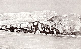
The Kirwan Escarpment is a prominent northwest-facing escarpment which lies south of the Penck Trough in Queen Maud Land, Antarctica. The escarpment is featured by moderate-height cliffs and prominent rock spurs interspersed with glaciers and steep ice slopes and trends northeast–southwest for about 90 nautical miles (170 km). At least the northern end of this feature was included in the aerial photography of the general area by the Third German Antarctic Expedition (1938–39), but the maps resulting from that expedition do not portray the escarpment properly. The escarpment was mapped by Norwegian cartographers from surveys and air photos (1958–59) and named for Laurence P. Kirwan, Director of the Royal Geographical Society.

The Blackhead Mountains range is located near the northern end of the Catskill Mountains, in Greene County, New York, United States, where it divides the towns of Windham and Jewett. The three named peaks in the range — Thomas Cole Mountain, Black Dome, and Blackhead Mountain — are the fourth-, third-, and fifth-highest peaks in the Catskills, respectively. The gap between Thomas Cole and Black Dome is, at 3,700 feet, the highest in the Catskills.
Walden Ridge is a mountain ridge and escarpment located in Tennessee in the United States. It marks the eastern edge of the Cumberland Plateau and is generally considered part of it. Walden Ridge is about 74 miles (119 km) long, running generally north-south. Its highest point is at Hinch Mountain, which reaches 3,048 feet (929 m) above sea level. Sometimes Walden Ridge is called the Cumberland Escarpment.
Kalonymus ben Kalonymus ben Meir, also romanized as Qalonymos ben Qalonymos or Calonym ben Calonym, also known as Maestro Calo was a Jewish philosopher and translator and hakham of Provence.

Laughing Whitefish Falls State Park is a public recreation area protecting 960 acres (390 ha) along the Laughing Whitefish River in Onota Township and Rock River Township, in far western Alger County, Michigan. Its main scenic feature is Laughing Whitefish Falls, a 100-foot fan-shaped cascade located in the southern part of the site, in Rock River Township, eight miles (13 km) south of Lake Superior and three miles north of M-94.

Indian Head Mountain is a 3,573 ft (1,089 m) mountain located in the southeast corner of Greene County, New York. The mountain, named for the appearance of its profile, is part of the Devil's Path range of the Catskill Mountains. To the northwest, Indian Head is separated from Twin Mountain by Jimmy Dolan Notch; to the southeast, Indian Head is flanked by Plattekill Mountain.
Crum Hill, 2,841 feet (866 m), located in northwest Massachusetts, United States, in the towns of Monroe and Florida, is the highest point in Franklin County. The mountain, part of the Hoosac Range, is crossed by a trail system maintained by a local snowmobile club, the Florida Mountaineers. They maintain a trail map on their website.

Red Rock Mountain is a mountain located in Luzerne County, Pennsylvania. This summit is actually on the North Mountain escarpment. The escarpment in which Red Rock Mountain is located is a part of the Allegheny Plateau. This summit features a firetower, known as "Grandview" all located within the Ricketts Glen State Park.
The Rampart Range is a mountain range in the western United States in Colorado, located in Douglas, El Paso, and Teller counties. Part of the Front Range of the Rocky Mountains, the range is almost entirely public land within the Pike National Forest.
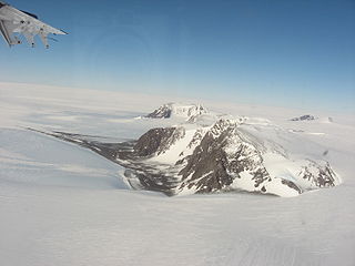
Watson Escarpment is a major escarpment in the Queen Maud Mountains, trending northward along the east margin of Scott Glacier, then eastward to Reedy Glacier where it turns southward along the glacier's west side. Somewhat arcuate, the escarpment is nearly 100 nautical miles long, rises 3,550 metres (11,650 ft) above sea level, and 1,000 to 1,500 metres above the adjacent terrain.
Sugarloaf Mountain is a mountain in Sullivan County, New York. It is located northeast of Grahamsville. Denman Mountain is located west-northwest, Kalonymus Escarpment is located south-southeast, and South Hill is located south-southwest of Sugarloaf Mountain.

