
This is part of the list of United Kingdom locations: a gazetteer of place names in the United Kingdom showing each place's locality and geographical coordinates.
This is part of the list of United Kingdom locations: a gazetteer of place names in the United Kingdom showing each place's locality and geographical coordinates.
| Location | Locality | Coordinates (links to map & photo sources) | OS grid reference |
| East Ness | North Yorkshire | 54°11′N0°56′W / 54.19°N 00.94°W | SE6978 |
| East Nevay | Angus | 56°35′N3°05′W / 56.58°N 03.09°W | NO3344 |
| East Newton | East Riding of Yorkshire | 53°49′N0°05′W / 53.81°N 00.08°W | TA2637 |
| East Newton | North Yorkshire | 54°12′N1°01′W / 54.20°N 01.02°W | SE6479 |
| Eastney | City of Portsmouth | 50°47′N1°04′W / 50.78°N 01.06°W | SZ6699 |
| Eastnor | Herefordshire | 52°02′N2°23′W / 52.03°N 02.39°W | SO7337 |
| East Norton | Leicestershire | 52°35′N0°50′W / 52.59°N 00.84°W | SK7800 |
| East Nynehead | Somerset | 50°59′N3°13′W / 50.99°N 03.21°W | ST1522 |
| Location | Locality | Coordinates (links to map & photo sources) | OS grid reference |
| East Panson | Devon | 50°42′N4°19′W / 50.70°N 04.32°W | SX3692 |
| East Parley | Dorset | 50°46′N1°51′W / 50.77°N 01.85°W | SZ1097 |
| East Peckham | Kent | 51°12′N0°22′E / 51.20°N 00.37°E | TQ6648 |
| East Pennard | Somerset | 51°08′N2°35′W / 51.13°N 02.58°W | ST5937 |
| East Perry | Cambridgeshire | 52°17′N0°19′W / 52.28°N 00.31°W | TL1566 |
| East Portlemouth | Devon | 50°13′N3°46′W / 50.22°N 03.76°W | SX7438 |
| East Prawle | Devon | 50°13′N3°43′W / 50.21°N 03.71°W | SX7836 |
| East Preston | West Sussex | 50°48′N0°29′W / 50.80°N 00.48°W | TQ0702 |
| East Preston | Dumfries and Galloway | 54°53′N3°37′W / 54.88°N 03.62°W | NX9656 |
| East Pulham | Dorset | 50°52′N2°23′W / 50.87°N 02.39°W | ST7209 |
| East Putford | Devon | 50°55′N4°20′W / 50.92°N 04.33°W | SS3616 |
| Location | Locality | Coordinates (links to map & photo sources) | OS grid reference |
| East Quantoxhead | Somerset | 51°10′N3°14′W / 51.17°N 03.24°W | ST1343 |
| Location | Locality | Coordinates (links to map & photo sources) | OS grid reference |
| East Taphouse | Cornwall | 50°26′N4°34′W / 50.43°N 04.56°W | SX1863 |
| East-the-Water | Devon | 51°01′N4°11′W / 51.01°N 04.19°W | SS4626 |
| East Third | Scottish Borders | 55°37′N2°34′W / 55.61°N 02.57°W | NT6436 |
| East Thirston | Northumberland | 55°17′N1°42′W / 55.28°N 01.70°W | NZ1999 |
| East Tilbury | Essex | 51°28′N0°25′E / 51.47°N 00.41°E | TQ6878 |
| East Tisted | Hampshire | 51°05′N1°00′W / 51.08°N 01.00°W | SU7032 |
| East Torrington | Lincolnshire | 53°20′N0°17′W / 53.33°N 00.28°W | TF1483 |
| East Town (Pilton) | Somerset | 51°09′N2°34′W / 51.15°N 02.57°W | ST6040 |
| East Town (Tolland) | Somerset | 51°05′N3°17′W / 51.08°N 03.28°W | ST1032 |
| East Town | Wiltshire | 51°17′N2°09′W / 51.29°N 02.15°W | ST8955 |
| East Trewent | Pembrokeshire | 51°38′N4°53′W / 51.63°N 04.89°W | SS0097 |
| East Tuddenham | Norfolk | 52°39′N1°04′E / 52.65°N 01.07°E | TG0811 |
| East Tytherley | Hampshire | 51°03′N1°35′W / 51.05°N 01.58°W | SU2928 |
| East Tytherton | Wiltshire | 51°28′N2°03′W / 51.46°N 02.05°W | ST9674 |
| Location | Locality | Coordinates (links to map & photo sources) | OS grid reference |
| East Village | Devon | 50°50′N3°38′W / 50.83°N 03.64°W | SS8405 |
| East Village | The Vale Of Glamorgan | 51°27′N3°27′W / 51.45°N 03.45°W | SS9974 |
| Eastville | City of Bristol | 51°28′N2°34′W / 51.47°N 02.56°W | ST6175 |
| Eastville | Lincolnshire | 53°05′N0°05′E / 53.08°N 00.08°E | TF4056 |
| Location | Locality | Coordinates (links to map & photo sources) | OS grid reference |
| East Youlstone | Cornwall | 50°54′N4°28′W / 50.90°N 04.46°W | SS2715 |

The Parliament of the United Kingdom is the supreme legislative body of the United Kingdom, the Crown dependencies and the British overseas territories. It alone possesses legislative supremacy and thereby ultimate power over all other political bodies in the UK and the overseas territories. Parliament is bicameral but has three parts, consisting of the sovereign (Crown-in-Parliament), the House of Lords, and the House of Commons. The two houses meet in the Palace of Westminster in the City of Westminster, one of the inner boroughs of the capital city, London.

Northern Ireland is variously described as a country, province, or region, which is part of the United Kingdom. Located in the northeast of the island of Ireland, Northern Ireland shares a border to the south and west with the Republic of Ireland. In 2011, its population was 1,810,863, constituting about 30% of the island's total population and about 3% of the UK's population. Established by the Northern Ireland Act 1998 as part of the Good Friday Agreement, the Northern Ireland Assembly holds responsibility for a range of devolved policy matters, while other areas are reserved for the British government. Northern Ireland co-operates with the Republic of Ireland in several areas, and the Agreement granted the Republic the ability to "put forward views and proposals" with "determined efforts to resolve disagreements between the two governments".

A primary school, junior school, elementary school or grade school is a school for children from about four to eleven years old, in which they receive primary or elementary education. It can refer to both the physical structure (buildings) and the organisation. Typically it comes after preschool, and before secondary school.

The United Kingdom of Great Britain and Northern Ireland, commonly known as the United Kingdom or Britain, is a sovereign country located off the northwestern coast of the European mainland. The United Kingdom includes the island of Great Britain, the northeastern part of the island of Ireland, and many smaller islands. Northern Ireland shares a land border with the Republic of Ireland. Otherwise, the United Kingdom is surrounded by the Atlantic Ocean, with the North Sea to the east, the English Channel to the south and the Celtic Sea to the southwest, giving it the 12th-longest coastline in the world. The Irish Sea separates Great Britain and Ireland. The total area of the United Kingdom is 94,000 square miles (240,000 km2).
The Peerage of Ireland consists of those titles of nobility created by the English monarchs in their capacity as Lord or King of Ireland, or later by monarchs of the United Kingdom of Great Britain and Ireland. The creation of such titles came to an end in the 19th century. The ranks of the Irish peerage are Duke, Marquess, Earl, Viscount and Baron. As of 2016, there were 135 titles in the Peerage of Ireland extant: two dukedoms, ten marquessates, 43 earldoms, 28 viscountcies, and 52 baronies. The Crown of the United Kingdom of Great Britain and Northern Ireland continues to exercise jurisdiction over the Peerage of Ireland, including those peers whose titles derive from places located in what is now the Republic of Ireland. Article 40.2 of the Constitution of Ireland forbids the state conferring titles of nobility and a citizen may not accept titles of nobility or honour except with the prior approval of the Government. This issue has not arisen in respect of the Peerage of Ireland because, as observed above, no creation of titles in it has been made since the Constitution came into force.

A Commonwealth realm is a sovereign state which has Elizabeth II as its monarch and head of state. Each realm functions as an independent co-equal kingdom from the other realms.

A dynasty is a sequence of rulers from the same family, usually in the context of a feudal or monarchical system, but sometimes also appearing in elective republics. Alternative terms for "dynasty" may include "house", "family" and "clan", among others. The longest-surviving dynasty in the world is the Imperial House of Japan, otherwise known as the Yamato dynasty, whose reign is traditionally dated to 660 BC.

The Kingdom of England was a sovereign state on the island of Great Britain from 927, when it emerged from various Anglo-Saxon kingdoms until 1707, when it united with Scotland to form the Kingdom of Great Britain.

The 1886 United Kingdom general election took place from 1 to 27 July 1886, following the defeat of the Government of Ireland Bill 1886. It resulted in a major reversal of the results of the 1885 election as the Conservatives, led by Lord Salisbury, were joined in an electoral pact with the breakaway Unionist wing of the Liberals led by Lord Hartington and Joseph Chamberlain. The new Liberal Unionist party gave the Conservatives their parliamentary majority but did not join them in a formal coalition.
This is a list of lists of places in Wales.
The territorial evolution of the British Empire is considered to have begun with the foundation of the English colonial empire in the late 16th century. Since then, many territories around the world have been under the control of the United Kingdom or its predecessor states. When the Kingdom of Great Britain was formed in 1707 by the union of the Kingdom of Scotland with the Kingdom of England, the latter country's colonial possessions passed to the new state. Similarly, when Great Britain was united with the Kingdom of Ireland in 1801 to form the United Kingdom, control over its colonial possessions passed to the latter state. Collectively, these territories are referred to as the British Empire. Upon much of Ireland gaining independence in 1922 as the Irish Free State, the other territories of the Empire remained under the control of the United Kingdom.

The Parliament of the United Kingdom currently has 650 parliamentary constituencies across the constituent countries, each electing a single member of parliament (MP) to the House of Commons by the plurality voting system, ordinarily every five years. Voting last took place in all 650 of those constituencies at the United Kingdom general election on 12 December 2019.
In the United Kingdom, a Member of Parliament (MP) is an individual elected to serve in the House of Commons of the Parliament of the United Kingdom.
The World Figure Skating Championships is an annual figure skating competition sanctioned by the International Skating Union in which figure skaters compete for the title of World Champion.
The United Kingdom has participated in the Eurovision Song Contest 62 times. They first participated in the second contest in 1957. The UK has entered every year since 1959, and along with Sweden and the Netherlands, is one of only three countries with Eurovision victories in four different decades. The United Kingdom is one of the "Big 5", along with France, Germany, Italy and Spain who are automatically allowed to participate in the final as they are the five biggest financial contributors to the European Broadcasting Union (EBU). The British public broadcaster, the BBC, broadcasts the event each year and organises the national selection for the entry. The UK has won the contest five times, and has finished second on a record fifteen times.
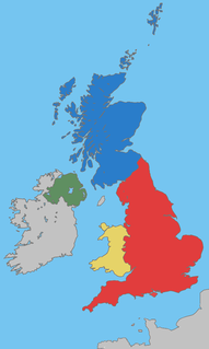
The United Kingdom of Great Britain and Northern Ireland (UK), since 1922 comprises four constituent countries: England, Scotland, and Wales, as well as Northern Ireland.
The World Figure Skating Championships is an annual figure skating competition sanctioned by the International Skating Union in which figure skaters compete for the title of World Champion.